
Gandenitz
|
Gandenitz
City of Templin
Coordinates: 53 ° 10 ′ 18 ″ N , 13 ° 26 ′ 24 ″ E
|
|
|---|---|
| Height : | 63 m above sea level NHN |
| Area : | 14.58 km² |
| Residents : | 276 (Jul. 2013) |
| Population density : | 19 inhabitants / km² |
| Incorporation : | October 26, 2003 |
| Postal code : | 17268 |
| Area code : | 03987 |
Gandenitz is a district of the unofficial city of Templin in the Uckermark district ( Brandenburg ). Gandenitz was an independent municipality until 2003.

Geographical location
Gandenitz is approx. 7.2 km as the crow flies northwest of the (core) city of Templin. The district borders on Warthe (district of the Boitzenburger Land community ) in the north, Klosterwalde (district of the city of Templin) in the east, the district of the core town of Templin in the south, Densow (district of the city of Templin) in the south-west and in the northwest the district of the core town Lychen . Gandenitz can be reached from Templin first via the L 23 and then branching off from this street on the K 7330. This county road continues via Alt Placht to Densow. The K 7357 begins in the village and leads to Mahlendorf (living space in the district of Warthe in the Boitzenburger Land community).
The greater part of the district is forested. The highest elevations are the Leiterberge in the north of the district with 109.5 m. The lowest point is the small bank area of the Netzowsee, which still belongs to Gandenitz, at 51.4 m. The small Fienensee and Schulzensee are located on the southern border of the district, but still close to the village . They are connected to one another by the Hermsdorfer Beck (also Knehdenfließ), which flows into the Schulzensee . The Hermsdorfer Beck (formerly Hermsdorfer Beke) leads on to Netzowsee. The Metzelthiner forest ditch, which comes from the Moses Krug residential area, flows into the Hermsdorfer Beck southeast of the town center. In the Urmes table sheet from 1826, another small lake without a name is recorded southeast of the town center in the course of the Hermsdorfer Beck. The Kripkensee , called by Berghaus , is today on the outskirts of the core town of Templin.
The district of Gandenitz today includes the Küstrinchener Weg , Moses Krug and Heckenhaus Hohenheide residential areas . Around 1900 there were other places to live: the Griebchen game keeper's house, a gate keeper's house west of today's Heckenhaus Hohenheide, a gate keeper's house on the road to Mahlendorf, in the immediate vicinity of the Leiterberge and the Teerofen residential area (which was named as a residential area in 1967). The Griebchen forester's house was already there around 1825, but it was not until 1929 that it became part of the Gandenitz district. In 1967 it was still called Waldwärterhaus Wuppgarten as a living space, but has also disappeared today.
history
The first documentary mention of the place took place in 1319 in a document of the Brandenburg Margrave Waldemar . It is referred to as "Gandenitcz", in the inscription given by Riedel it is Gandenitz. According to the wording of the document, Waldemar gave the church in Havelberg the villages of Polssen and Hermsdorf , located near Gandenitz (which later fell in ruins and was not rebuilt). The name is derived from an old Polish basic form * Gąd-nici , which means "place where people of a man named Gąd-n live". The personal name goes back to an ancient Slavonic form * gosti, godo violin , make music, play. According to the village structure, Gandenitz is an Angerdorf , a typical form of the German eastern settlement. In 1324, the Brandenburg Margrave Ludwig I and the Mecklenburg Duke Heinrich II concluded a settlement over the Vogteien Jagow , Stolp (e) and Liebenwalde in Gandenitz. In the land book of Charles IV of 1375 Gandenitz is described as follows:
“Gandenitze 52 [mansi]. Quilibet dat in pactum 12 solidos; precaria 3 solidi, 1 modius siliginis, 1 modius ordei, 2 modii avene. Ad dotem iacent 4 mansi, quos plebanus habet sub cultura. Filii Martini Tuneman have pactum super 4 mansos. Tydeke Hindenborg, civis in Templyn, has pactum super 4 mansos. Herman Barstorp has pactum super 9 mansos. Petyr Colene cum patruis suis habet pactum super 6 mansos. Czacheus Redelstorp had pactum super 4 mansos. Residuos pactus et precarias had Hynr. Slepekow cum fratribus suis. De hiis [mansis] sunt in possessione 16 habent libertatem ad triennium; alii iacent desolati. Taberna dat 24 solidos et est desolata. Costenworde 14, quelibet dat 6 denarios et 1 pullum et iacent desolatae. Prope villam iacet molendinum dans in pactum 2 choros annone et est desolatum, pertinens ad Spiritum sanctum in Temply. Prope hanc villam iacet Kaltbrake (limestone quarry), de quo datur 1 talentum; item stagnum super quod 2 tractiones say, spectans ad Sanctum Spiritum in Templyn. "
The village had 52 hooves . Each hoof gave 12 shillings for rent, 3 shillings for Bede, 1 bushel of rye, 1 bushel of barley and 2 bushels of oats. The pastor worked on 4 dotal hooves. The sons of Martin Tunemann obtained the lease of 4 Hufen. Tydeke Hindenburg, a citizen of Templin, pulled in the lease of 4 hooves, Hermann Barstorf was entitled to the lease of 9 hooves and Peter Colene to the lease of 6 hooves. Zacheus Redelsdorf had the raising of the lease of 4 hooves and the lease of the remaining hooves and the bede went to Heinrich Slepekow and his brothers. Of these remaining hooves, 16 were farmed, but were exempt from taxes for three years. The other hooves lay desolate. The jug lay in ruins and gave 24 shillings beforehand. The 14 cottages were also desolate; beforehand they each gave 6 pfennigs and a chicken. The mill near the village was also desolate; She previously gave 2 Wispel grain ("annone") on lease to the Heilig-Geist-Hospital in Templin. The limestone quarry near the village gave 1 talent. The nearby lake also belonged to the Heilig-Geist-Hospital in Templin and brought in 2 yarn trains of fish.
15th and 16th centuries
| year | Residents |
|---|---|
| 1734 | 110 |
| 1774 | 150 |
| 1790 | 90 |
| 1801 | 222 |
| 1817 | 230 |
| 1840 | 344 |
| 1858 | 636 |
| 1895 | 478 |
| 1925 | 427 |
| 1939 | 443 |
| 1946 | 554 |
| 1964 | 404 |
| 1971 | 263 |
| 1981 | 302 |
| 1991 | 282 |
| 2002 | 319 |
| 2013 | 276 |
In 1416 the Stepken brothers were enfeoffed with the donation of 16 hooves in Gandenitz. They had the right to extract lime in the district. They had the courts, carriage services and the Schulzengericht. In 1445 the village fell in desolation. The Brandenburg Elector Friedrich II ("the Iron", also called Eisenzahn) lent the desert Feldmark to the city of Templin. Only 2 farms with 4 hooves owned by Achim vdWarte were excluded from this. However, they should later also be sent to the city of Templin. The elector had, however, reserved the right to break lime, ie he could also grant this right to other people. In a document from 1459, the village is explicitly described as desolate (= uninhabited). In 1464, Elector Friedrich granted the city of Lychen the right to dig limestone on the Gandenitz field mark and to break limestone as required. It is not known exactly when the village was rebuilt. In 1560 Gandenitz was z. In any case, some of them were rebuilt, and the Feldmark cleared (some of them). It was Kirchdorf again; the pastor had two hooves free. The bell of 1567 should also mark the terminus post quem non of the restoration of the church. For the year 1578 again eleven farmers who cultivate eleven Hufen, a kossate, a shepherd and a lease shepherd are named, which means that possibly only a part of the earlier fields were taken back into cultivation. Another possibility would be that three hooves of the 52 hooves from 1375 were merged and the farmers managed larger hooves with them.
17th century
In the years after 1616 the lime kiln was also back in operation. There was a sheep farm and an arable farm owned by the City Council of Templin. A1624 lived eleven farmers who cultivated eleven Hufen and a kossate in the village. The village was completely destroyed in the Thirty Years War. The residents perished or fled. In 1649 the deserted Feldmark was pledged to a citizen named Fehlow. The fields were grown together again. In 1696 the city council released the pledge again.
18th century
In 1701 a storm destroyed the pine forest near Gandenitz. Then a tar furnace was built and leased for eight years. He was allowed to smolder the no longer usable wood from the storm damage. In 1702 the village was z. T. rebuilt. 571 acres (300 square rods ) and eight wörden were cleared again, but 355 acres were still overgrown. The field was described as "mediocre good". The fields were divided into eleven taxable hooves and one knight's hoof. The size of a hoof, minus the fallow (one third), was 52 acres, 16½ square rods. The lease for the tar stove was not renewed in 1709 due to a lack of wood. In 1711, residents were named as follows: ten farmers, two pairs of householders, a tenant shepherd and a shepherd without cattle. The eleven taxable hooves had to be taxed at six groschen.
In 1731 the so-called manor of the city of Templin was described in more detail. It had 139 acres (at 400 QR) or 310 acres (at 180 QR) of land in three fields on the Gandenitz field, in the knight-free, so-called pasture hooves, another 119 acres (at 400 QR) or 264 acres (at 180 QR) on the field mark of the desert village of Hermsdorf (including the so-called churchyard) and 34 acres or 75 acres on the so-called Herrenbreiten (or court hooves) on the desert field mark Hermsdorf. Altogether the estate had 292 new acres or 649 old acres and 36 (new?) Acres of meadows, on which 16 cattle, 800 sheep, pigs and poultry were kept. The city of Templin was also represented under the knighthood in the state parliament because of the so-called manors Gandenitz, Knehden and Stempnitz. In 1734 the population is given as ten farmers, three kossäts, three housewives, a linen weaver, a tailor, two shepherds, a shepherd, ten servants and seven maidservants. The eleven hooves were 28 (new) acres in size and 179 square rods. Before 1771, another tar furnace was built in the Gandenitz district. He was about 2.2 km north-northeast of the town center. It existed until at least 1860. Today, the place to live has completely disappeared. In 1775 Gandenitz became an independent parish again. There was a Vorwerk (the so-called Rittergut), a sheep farm, a tar furnace and a horticultural dwelling ( Unterforsterei ). In addition to the ten farmers, there were 10 cottagers and 20 farmers and residents living in the village. There were a total of 27 fireplaces. In 1781 the manor was leased to the community of Gandenitz for an annual lease of 393 thaler and 15 groschen and the payment of inheritance money of 400 thaler. In 1784, however, the estate was ceded to Tobias Conrad Hornung from Siegrothsbruch (Gem. Dreetz , district of Ostprignitz-Ruppin). The annual rent had been reduced to 340 thalers. In 1795 belonged to this estate: a Ritterhufe Acker, the Wehdehof in Gandenitz, the Herrenbreiten (on the original Hermsdorfer Feldmark), the "Eichwerder" (today?), The desert village of Hermsdorf (southeast of the village center) and the three lakes "Bergsee" "(Silted up), Schulzensee and" Finnsee "(Fienensee).
19th century
In 1801 the village is described as follows: 10 "Ganzbauern" (full farmers), 3 Ganzkossäts, 22 residents, a forge, jug, tar oven and a forester's house in the Gandenitzer Heide. A total of 27 fireplaces were counted. In 1805 the Gandenitz estate went to a certain Rohde, whose family was tenants until at least 1850. Around 1850, even after 22 thalers, 12 groschen and 6 pfennigs were levied on the estate because of the Wehdehof and 22 bushels of rye in kind. In the event of a sale, a laudemium of 266 thalers, 2 groschen and 6 pfennigs must be paid. Parts of the property were also on the field mark of the city of Templin. In 1840 the village had grown to 45 houses. In 1843 a major fire destroyed almost the entire south side of the village. 39 families with around 130 people became homeless. Fire brigades with 19 syringes and 27 water vehicles were in action from the towns of Templin and Lychen and the surrounding villages.
The widow Beyer applied for permission to build a mill in Gandenitz in 1842. In 1848 the farmer August Schulze received permission to build another windmill, "44 rods from Mahlendorfer Weg and 250 rods from the village". In 1852 a new school was built. In 1852, Schulze from Gandenitz submitted the plan for approval to build a new tar oven on the site of the old tar oven and also to build a brick factory on his field. The brick factory was not actually set up until 1860. It was probably around the brick factory drawn east of the Küstrinchener Weg residential area in 1900. In 1860 there were 5 public buildings, 51 residential houses and 86 farm buildings, including two post windmills and a tar stove. The estate consisted of three residential buildings and nine farm buildings. One post mill stood north of the village center on a small hill behind the houses at Mahlendorfer Strasse 12 to 16. The spot is still marked today by a circular plot of land. The social structure of the village was well described in 1861 (excluding farmers). In Gandenitz lived a merchant, two agents, a ship's crew, an innkeeper, two linen weavers with two assistants, two brickworkers, a mill master with two assistants, two master bakers, three bricklayers, two carpenters, a cartwright, a blacksmith, two master shoemakers, and a master tailor with an assistant, two seamstresses, two master carpenters, and a musician (!) with four assistants. In 1868 Schulze Gollin was elected Deputy Fire Extinguishing Commissarius for the Xth District of the Templin district.
In 1900 there were already 75 houses. Around 1900, a clay pit was drawn northwest of the town center.
20th and 21st centuries
In 1907 an assistant forester lived in the Eichkamp forestry department. In 1931 the village had grown to 83 houses and in 1939 there were 443 registered residents. Three landowners had 93, 52 and 47 hectares. Six farmers had estates between 23 and 50 hectares. Twelve people owned between one hectare and 18 hectares, including a mason foreman and two musicians. The two innkeepers owned 7 and 13 hectares of land. The master blacksmith owned 5.5 hectares, the bakery owner 5 hectares. A building contractor owned 4 hectares and a merchant's wife 9 hectares. A bricklayer foreman, a forester, a retired royal forester were also named ., a military trainee, two teachers, two rentiers and a landowner living in Templin who managed the former manor, which was over 100 hectares in size. In 1939 the former manor had already been divided up. According to the historical local lexicon, the Eichkamp forest ranger was now called Moses Krug. In 1958 the first agricultural production cooperative (LPG) type III (joint arable farming and joint livestock farming) existed with 44 members and 279 hectares of agricultural land. In 1960 a second type I LPG (joint field cultivation) was formed, in which 46 people came together and brought in 290 hectares of usable area. LPG Type I still had 42 members on 291 hectares of usable area. In 1968 it was connected to the LPG type III. In 1978 the forest ranger's department of the State Forestry Company Templin was located in Gandenitz.
Political history
The originally margravial place was temporarily owned by Mecklenburg and Pomerania in the first half of the 14th century. From 1375 until after 1416 it was owned by the Slepke family. The citizens of Kraetze and Schile must have come into possession of Gandenitz before 1445, because they are mentioned as the previous owners when the Brandenburg Margrave Friedrich II lent the desert village to the city of Templin. The place remained in the possession of the city of Templin until 1872. Gandenitz belonged to the Uckermark District until the district reform of 1815/6 , and to the district of Templin after the district reform . During the district reform of 1952, Gandenitz remained with the newly cut Templin district , which was renamed the Templin district in 1990 . In 1993 the three Uckermark districts of Angermünde , Prenzlau and Templin were merged to form the Uckermark district. In 1992 Gandenitz merged with 13 other municipalities to form an administrative community, the Templin-Land Office . In 2003 Gandenitz, like the other municipalities of the Templin-Land office, was incorporated into the city of Templin by law, and the office was dissolved. Since then, Gandenitz has been part of the city of Templin.
Church history
In 1375 Gandenitz was the mother church and belonged to the Sedes Templin. After the resettlement in the 16th century, Gandenitz was again the mother church. In 1618 the pastor lived in Templin. From 1692 to 1717 Gandenitz was again the mother church.
Monuments
The list of monuments of the state of Brandenburg for the district of Uckermark shows only one monument for Gandenitz:
- Gandenitz village church. The rectangular stone church in Gandenitz dates from the 2nd half of the 13th century.
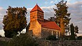
Field stone church "St. Peter and Paul"
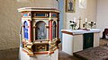
Pulpit restored in 2013


Other monuments and notable buildings

- War memorial at Gandenitz Cemetery, inaugurated in 1921
- Old inn
- Former school building. The building was built in 1852 and the school was expanded in 1865. From 1951 on, only 1st to 4th grade students were taught here. The school was closed in 1975.
- Former bakery. Presumably set up around the middle of the 19th century. A post mill was operated in addition to the bakery until 1935, which was torn down in 1951. The bakery closed in 1973.
- Old Forge. The forge dates back to the middle of the 19th century, in 1852 the master blacksmith and judge August Behrend owned the forge. The forge operated until 1955.
- Some half-timbered houses on the village green
- Gasthof "Zur Linde"
literature
- Heinrich Karl Wilhelm Berghaus: Land book of the Mark Brandenburg and the Markgrafthum Nieder-Lausitz in the middle of the 19th century; or geographical-historical-statistical description of the Province of Brandenburg, at the instigation of the State Minister and Upper President Flottwell. First volume. 684 p., Printed and published by Adolph Müller, Brandenburg 1854 (hereinafter abbreviated, Berghaus, Landbuch, vol. 1, with corresponding page number)
- Heinrich Karl Wilhelm Berghaus: Land book of the Mark Brandenburg and the Markgrafthum Nieder-Lausitz in the middle of the 19th century; or geographical-historical-statistical description of the Province of Brandenburg, at the instigation of the State Minister and Upper President Flottwell. Second volume. 650 p., Printed and published by Adolph Müller, Brandenburg 1855 (abbreviated below, Berghaus, Landbuch, vol. 2, with corresponding page number).
- Lieselott Enders : Historical local dictionary for Brandenburg. Part VIII Uckermark. 1210 p., Hermann Böhlaus successor, Weimar 1986 ISBN 3-7400-0042-2 (p. 297-300)
- Adolph Friedrich Johann Riedel : Codex Diplomaticus Brandenburgensis A. First main part or collection of documents on the history of spiritual foundations, the noble families, as well as the towns and castles of the Mark Brandenburg, XIII. Band, Die Uckermark: Lychen, Zehdenik, Templin, Angermünde, Chorin Monastery; Uckermark documents. Berlin, Reimer 1857 Online at Google Books (hereinafter abbreviated CDB A XIII with the corresponding certificate number)
- Johannes Schultze: The land book of the Mark Brandenburg from 1375. Brandenburg land books Volume 2, 470 S., Commission publisher by Gsellius, Berlin 1940.
- Sophie Wauer: Brandenburg name book. Part 9. The place names of the Uckermark. 391 pp., Verlag Hermann Böhlaus Successor, Weimar 1996 ISBN 3-7400-1000-2 (pp. 108–109)
Individual evidence
- ↑ Main statutes of the city of Templin from December 16, 2009 PDF
- ^ Berghaus, Landbuch, Vol. 1, p. 430 Online at Google Books
- ^ Service portal of the Brandenburg State Administration - City of Templin
- ^ A b Adolph Friedrich Johann Riedel : Codex Diplomaticus Brandenburgensis B. Second main part or collection of documents for the history of foreign affairs, 2nd volume. Berlin, FH Morin 1845 Online at Google Books (p. 25)
- ↑ a b Enders (1986: pp. 297-300)
- ↑ Contribution to the statistics of the State Office for Data Processing and Statistics. Historical municipality register of the State of Brandenburg 1875 to 2005 7.15 pm District Uckermark PDF
- ↑ Ernst Fidicin: The territories of the Mark Brandenburg or history of the individual districts, cities, manors and villages in the same, as a continuation of the land book of Emperor Charles IV; The Prenzlau district, the Templin district, the Angermünde district. XII, 270 p., Berlin, de Gruyter 1864 Online at Google Books (p. 133/4)
- ↑ CDB A XIII, No. 106, p. 107.
- ^ Berghaus, Landbuch, Vol. 2, p. 281 Online at Google Books
- ↑ a b c d e f g h i History of the district of Gandenitz ( Memento of the original from April 2, 2016 in the Internet Archive ) Info: The archive link was inserted automatically and has not yet been checked. Please check the original and archive link according to the instructions and then remove this notice.
- ↑ Official Journal of the Royal Government of Potsdam and the City of Berlin, year 1842, 390 pp., Potsdam, 1842. Online at Google Books (p. 222)
- ↑ Official Gazette of the Royal Government of Potsdam and the City of Berlin, year 1848, 390 pp., Potsdam, 1848, online at Google Books (p. 207)
- ^ Official Journal of the Royal Government of Potsdam and the City of Berlin, 7th issue of February 14, 1868, p. 53 Online at Google Books
- ↑ List of monuments of the state of Brandenburg. Uckermark district. Status: December 31, 2016 PDF ( Memento of the original from September 8, 2017 in the Internet Archive ) Info: The archive link was inserted automatically and has not yet been checked. Please check the original and archive link according to the instructions and then remove this notice.
Ahrensdorf | Bag | Densow with Annenwalde , Neu Placht and Alt Placht | Gandenitz | Gollin with Reiersdorf | Groß Dölln with Bebersee , Groß Väter , Klein Väter and Klein Dölln | Grunewald | Mutton spring with Alsenhof | Herzfelde | Hindenburg | Klosterwalde with Metzelthin | Petznick with cross jug | Röddelin | Storkow | Vietmannsdorf with Dargersdorf
Residential places:
Albertshof |
Albrechtsthal |
Annenhof |
Bandelowshof |
Bassdorf |
Birkenhof |
Christianshof |
Döllnkrug |
Dollshof |
Dorettenhof |
Three houses |
Dusterlake |
Donkey hut |
Etashof |
Ferry jug |
Fennluch |
Forestry |
Forsthaus Buchheide |
Forsthaus Krams |
Forsthaus Laatz |
Forsthaus Ringofen |
Gleuenhof |
Good Gollin |
Heckenhaus Hoheheide |
Heinrichshof |
Henkinshain |
Hohenfelde |
Joachimshof |
Kannenburger lock |
Karlshof |
Kienheide |
Klosterwalder Mill |
Feuds |
Cuckoo home |
Küstrinchener Weg |
Lindenhof |
Ludwigshof |
Orient |
Moritzhof |
Moses jar |
Papenwieser Weg |
Paulinenhof |
Postheim |
Reinfeld |
Rieckshof |
Schorfheide lock |
Schmidtshof |
Schulenburgslust |
Schulzenfelde |
Stone dam |
Steinfeld |
Stempnitz |
Sydowshof |
Gatekeeper houses |
Vorwerk |
Forest house |
Waldhof |
Hamlet |
Werderhof |
Wucker |
To the Seehof