Malt (Oranienburg)
|
malt
City of Oranienburg
Coordinates: 52 ° 48 ′ 13 ″ N , 13 ° 17 ′ 41 ″ E
|
|
|---|---|
| Height : | 38 m |
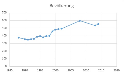
| Residents : | 554 (Dec. 31, 2014) |
| Incorporation : | October 26, 2003 |
| Postal code : | 16515 |
| Area code : | 03301 |
Malz is a district of the German district town of Oranienburg .
geography
Malt is located in the natural area of the Zehdenick-Spandau Havel lowlands .
history
Malz is a former skipper 's village that became famous for the construction of the Malzer Canal and the Oder-Havel Canal . The place name comes from Slavic and means swamp forest . In 1527 the area was acquired by the von Pfuel noble family . The village is said to have emerged after the Thirty Years War , after a tar burner from the Briesetal settled here on the "Malz". Holzhauer and Büdner moved here from Friedrichsthal in the 18th century . In the 19th century, many boat families followed them. To overcome the height difference between the Oder-Havel Canal and the Malzer Canal, the Malz lock was built in 1824 and a second lock chamber was added around 1874. With the completion of the Oder-Havel Canal, the Malzer lock was no longer needed for freight traffic and is now only used to regulate the water level. Even today there is a boat service and a shipyard that builds special ships in Malz. The shipyard's oldest surviving factory building dates from 1896. In 2003, Malz lost its independence in the course of the municipal reform in Brandenburg and is now part of the district town of the Oberhavel - Oranienburg district .
Monuments
Approximately in the center of the village, next to the sidewalk under a large oak, there has been a memorial plaque since 2005, which commemorates the former night watchman from Malz.
On the headland at the junction of the Malzer Canal from the Oder-Havel Canal stands an obelisk, which is intended to commemorate the construction of the Oder-Havel Canal. The headland is not accessible to the public as it is accessed via the Malzer Werft site. The obelisk was badly weathered over time and barely recognizable. In 2009 it was restored or almost rebuilt on the initiative of some citizens with the support of the water transport authority.
Local partnerships
Until Malz was incorporated into the city of Oranienburg , the municipality of Malz had a partnership with Hopfen am See .
Swiss hut
In 1898 the place Schweizerhütte was incorporated. Schweizerhütte is located north of Malz in the forest approximately at the level of the village Bernöwe , from which it is separated by the Havel and Oder-Havel Canal , as there is no bridge there. The place Schweizerhütte has no permanent residents (the last resident died in the 1990s), there are only a few bungalows.
traffic
The OVG bus line 804 runs to the stops in Malz (Grabowsee ferry, Schleuse, Am Gang, Anker, Dameswalder Weg, Ambachwiesen) approximately every hour.
Population development
literature
- Sonja Wüsten: Märkische Miniatures. Unknown villages and mansions. Volume 1, Das Neue Berlin Verlagsgesellschaft mbH, 2001, ISBN 3-360-00968-1
Web links
- The homepage of Malz
- Information about the Malzer lock
- Official website of the city of Oranienburg for OT Malt
Individual evidence
- ^ Leopold von Ledebur: Adelslexikon der Prussischen Monarchy . Rauh, 1856, p. 196.
- ↑ picture of the monument
- ↑ Population development in 2013 and 2014 ( Memento of the original from March 4, 2016 in the Internet Archive ) Info: The archive link was inserted automatically and has not yet been checked. Please check the original and archive link according to the instructions and then remove this notice.
- ↑ Population development in 1988 and 2010

