
Schmachtenhagen
|
Schmachtenhagen
City of Oranienburg
Coordinates: 52 ° 46 ′ 3 ″ N , 13 ° 19 ′ 32 ″ E
|
|
|---|---|
| Height : | 48 m |
| Area : | 28.9 km² |
| Residents : | 2215 (2011) |
| Population density : | 77 inhabitants / km² |
| Incorporation : | October 26, 2003 |
| Postal code : | 16515 |
| Primaries : | 03301, 033053 |
Schmachtenhagen is a district of the district town of Oranienburg in Brandenburg and is located in the southeast of the Oberhavel district. The previously independent municipality joined the city of Oranienburg on October 26, 2003 and is administered by it.
Geography and transport links
location
Schmachtenhagen is located on the southeastern part of the northern Havel lowlands, the so-called Oberhavel. The old town center on the Anger with the church is located about 33 km north of the city center of Berlin. The highest points of the place are at an average of 20 m above sea level. NHN two hills near the western boundary of the municipality, the Fuchsberge and the Zwergberge . The lowest point at 43.3 m above sea level. NHN is located on a ditch in the northern part of the local area. The height of the town center at the church is about 50 m above sea level. NHN . The district of Schmachtenhagen covers an area of 28.9 km². It includes the lowlands of the Stintgraben , which run east along the Oder-Havel Canal, at the former Germania brickworks on the western edge of the village and borders the eastern bank of the Grabowsee , into which the Bäke brook, which meanders from east to west, also flows. The Stintgraben is the outflow of the Grabowsee and connected to the Lehnitzsee by a ditch network . The district is subdivided into several residential areas around the center (the historic village center around the village green) in the West settlements , which were built around 1910 , the Süd Siedlung (also known as the Marx and Holzhausen colony ), the Ost settlements, the settlement north of the Angers Upstall and the Bernöwe location outside .

Neighboring places
The Schmachtenhagen district is located around 7 km east of the core city of Oranienburg and near the eastern border of the large municipality of Wandlitz and the district of Barnim . Adjacent communities are in the west the city of Oranienburg with the districts Sachsenhausen , Friedrichsthal and Malz lying along the Oder-Havel Canal , in the north with the district Kreuzbruch belonging to the city Liebenwalde , in the east the formerly independent communities Zehlendorf and bordering the district Barnim Wensickendorf and in the south with the Schmachtenhagener Heide to the Mühlenbecker Land and to the southwest with the Oranienburger Heide bordering the Oranienburger district Lehnitz .
|
Friedrichsthal 4 km |
New Holland 15 km |
Kreuzbruch 4 km |
|
Oranienburg 7 km |
.svg)
|
Zehlendorf 8 km |
|
Lehnitz 6 km |
Mühlenbeck 14 km |
Zühlsdorf 9 km |
Transport links
From May 21, 1901 to 1998, the place had a nearby railway connection through the Heidekrautbahn stop built in the neighboring town of Zehlendorf on the route from Berlin-Wilhelmsruh to Liebenwalde (from 1961 from Berlin-Blankenburg , from 1976 Berlin-Karow ). Since 1998 the trains have usually only run to Wensickendorf. Schmachtenhagen has also been served since 2002, even if only at the weekend to go to a weekly market on the northern outskirts, and has a single-track stop at the Bauernmarktchaussee. The depot on Malzer Weg, built in 1950, has not been in operation since 1983, was dismantled in 1991/92 and has now grown over. In addition, Schmachtenhagen is connected to Oranienburg and Liebenwalde by a bus line operated by the Oberhavel Verkehrsgesellschaft and another line to the Bernöwe district. The federal road 273 (Potsdam – Bernau) crosses the village in an east-west direction and crosses the state road 29 (Schmachtenhagen – Biesental) on both sides of the Königliche or Alte Darre (the listed landmark of the place), at the same time the L 29 ends here. The S-Bahn, regional and long-distance train station Oranienburg is 5 km away, a connection to the federal highway 96 (Zittau – Rügen) in the district of Eden 10 km and the motorway entrances at the Berliner Ring within a 16 km radius: the Oranienburg junction 16 km, the Birkenwerder driveway 12 km, Mühlenbeck driveway 13 km, the connection to Europastraße 28 (Potsdam-Bernau-Poland) via the B 273 is 16 km away.
history
The first documentary mention is dated in a document signed in Bautzen on February 13, 1350 and stored in the Secret State Archives in Berlin-Dahlem, in which the place is called "Smachtenhagen" like many others in the area in the deeds of donation of the Margraves Ludwig der Brandenburger and Ludwig the Roman is mentioned, in which they enfeoffed Count Ulrich von Lindow with the Bötzow castle and surrounding villages.
In 1638, during the Thirty Years' War (1618–1648), the plague broke out and killed almost half of the villagers. The place and the country along the Havel were crossed and plundered by Danes, imperial armies and Swedes several times, destroying many houses and barns were. In addition, the Schmachtenhagener lost a lot of land due to the war tax. In 1642 the Bötzow office was pledged to Frau von dem Knesebeck , three years later the church was rebuilt and a parish office was set up. Since almost half of the farmsteads lay fallow in 1648, the village was rebuilt and settled with the support of Frau von dem Knesebeck. A few farmers who survived built new buildings on their own, others had new houses built. In 1651 the place became part of Bötzow (later Oranienburg) and thus the Bötzow office (from 1652: Oranienburg office ), and in 1745 it was added to the new Zehlendorf office . After the official seat was relocated in 1763, it became part of the Friedrichsthal office . In 1792 a forge was built between the kiln and the cemetery, which attracted additional residents to the village. In 1819 the Friedrichsthal office was dissolved again and Schmachtenhagen was reintegrated into the Oranienburg office.
At the beginning of the 19th century three self-contained settlements emerged. Between 1945 and 1990 the place was in the GDR , in the course of the municipal area reform it became a district again in October 2003 with an official seat in the city of Oranienburg.
| year | 1875 | 1890 | 1910 | 1925 | 1933 | 1946 | 1993 | 1994 | 1995 | 1996 | 1997 | 1998 | 1999 | 2000 | 2001 | 2002 | 2006 | 2010 | 2011 |
|---|---|---|---|---|---|---|---|---|---|---|---|---|---|---|---|---|---|---|---|
| Residents | 741 | 542 | 730 | 926 | 1.104 | 1,598 | 1,430 | 1,461 | 1,515 | 1,525 | 1,591 | 1,687 | 1,784 | 1,826 | 1,841 | 1,874 | 2,109 | 2,228 | 2285 |
Protestant church

In the 15./16. In the 19th century the place got its first stone church, which was often neglected and repaired in the following years. In 1699 it was given a new half-timbered tower , but fell victim to a fire in 1874 and was demolished. In December 1876, after a year and a half of construction, the yellow brick building, still standing today, in the neo-Romanesque round arch style with its around 30 meters high and widely recognizable square west tower with slate roof and apse and a long organ with eleven stops on two manuals was consecrated in its place. In the 1950s, however, it was changed significantly: the old structures and the old altar were removed, and the walls were whitewashed in a simple gray. The result was that some older residents avoided the church, which had been exposed to wind, weather, sponge and woodworm over the centuries, mainly because of its wooden ceiling, which was in danger of collapsing. Since 1997 - in addition to the funds from the community treasury - the local men's choir and a development association founded in 2005 have been financing the renovation in stages through donations and regular benefit concerts . After its restoration in 2007, the organ is again in excellent condition. Since then, efforts have been made to raise the money to install a heater.
Of the current population of around 2,000, around 190 are active Christians. Since the place does not have its own pastor, it is looked after by a clergyman from the parish office of Oranienburg-Süd.
Architectural monuments
- Soviet memorial in the Bernöwe district
- Gravestone in the cemetery in memory of seven French concentration camp prisoners from 1945
- Kiln building
- Protestant church
Attractions
- Royal forester's house near the Lehnitz lock
- Natural monument "Drei Buchen" on Gorkistraße
- Memorial for the prisoners of the Soviet special camp No. 7 who were shot between 1945 and 1950
- Forge ruins opposite the kiln building
- Cenotaph for the townspeople who died in the First and Second World Wars in the form of an obelisk with a name plaque and "Bismarck oak"
- old and renovated manor house (seat of the mayor) with fire department depot
- "Old school" built in 1850, now a daycare center
- Planted in 1815 and on the north end of the Angers, still on the Kita area, standing and marked with a field stone "Peace Oak 1815"
- Bridge to the old pitcher
- Bridge on the Elsenbusch

Royal forester's house
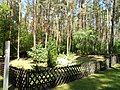
View of the burial ground
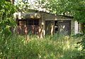
Ruins of the old forge

Old school

Daycare Bäkestrolche


tourism
- The long- distance cycle route Berlin – Copenhagen crosses the Bernöwe district .
- The Deutsche Tonstrasse runs through the village .
- In Schmachtenhagen there is a climbing park with several courses. In 2014 this is to be expanded to include a forest ropes course.
education
Since at least 1850 a school - the "old school" - has been named in the town's chronicles. The brick building is located at Schmachtenhagener Dorfstraße 14 next to the church, functioned as an elementary school until the end of the Second World War and currently houses the “Kita Bäkestrolche”. In 1946 the school moved to the “manor house” opposite, along with its outbuildings, at Dorfstraße 33 and, like all schools in the GDR , became POS Robert Neddermeyer in 1959 (also as an upper level for primary school students from Zehlendorf, Wensickendorf, Bernöwe) German reunification in the early 1990s for the Comprehensive school and because of the education reforms in the district, skills shortages and declining pupil numbers from about 2007 Neddermeyer - primary school .
politics
Local advisory board
| Party / candidate | be right | Seats |
|---|---|---|
| The left | 850 | 2 |
| CDU | 465 | 1 |
| SPD | 376 | 1 |
| LGU | 293 | 1 |
The last local elections took place on September 28, 2008. The turnout was 89.0 percent of the population eligible to vote. After that, the local advisory board, consisting of five people, is composed as shown in the table. The local advisory board has an advisory role for the community council of Oranienburg with regard to the decisions of the board that affect the Schmachtenhagen district. Some of the representatives of the local council are also community representatives. He meets in the manor house.
Mayor, town twinning
Schmachtenhagen had a mayor until the incorporation, since then a district mayor has been elected from among the elected community representatives, who is now called mayor. Hanz-Dieter Manzl ( Die Linke ) has held this honorary position since September 28, 2008 . The mayor's seat is in the community center at Schmachtenhagener Dorfstrasse 33.
Schmachtenhagen does not maintain its own local or town partnership. Since the formation of the large municipality of Oranienburg, the partnership agreements concluded by the village (steep) Schmachtenhagen at the end of the 1990s have been Bagnolet , ( France ) since 1964, Hamm , ( Germany ) since 1990, Mělník , ( Czech Republic ) since 1974, Vught , ( Netherlands ) since 2000, Friedrichsthal (Saar) , (Germany) since 1991 (since municipal reorganization in October 2003 regular twin town of Oranienburg) extended to the entire municipal area.
Individual evidence
- ^ Source for all information: The Genealogical Place Directory on genealogy.net/Schmachtenhagen
- ^ SPD Oranienburg , local elections 2008
Web links
- Schmachtenhagen on the website of the city of Oranienburg
- Schmachtenhagen on the Oberhavel Info website