Rüthnicker Heide
| Rüthnicker Heide | |
|---|---|
| surface | 97.5 km² |
| Systematics according to | Handbook of the natural spatial structure of Germany |
| Greater region 1st order | North German Lowlands |
| Greater region 2nd order | Central North German Lowland |
| Greater region 3rd order | 76–89 → East German plateau and heathland |
| Main unit group | 77 → North Brandenburg plateau and hill country |
| 4th order region (main unit) |
776–779 → Ruppiner Heiden and Platten |
| Natural space |
779 → Rüthnicker Heide |
| Natural area characteristics | |
| Landscape type | Pure forest landscape |
| Geographical location | |
| Coordinates | 52 ° 51 '18.7 " N , 13 ° 4' 48" E |
| local community | Kremmen , Löwenberger Land , Rüthnick |
| circle | Oberhavel , Ostprignitz-Ruppin |
| state | Brandenburg |
| Country | Germany |
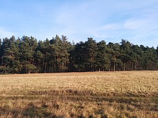
The Rüthnicker Heide is a forest area in the north of the state of Brandenburg . It forms a natural area in the North Brandenburg plateau and hill country . The Rüthnicker Heide extends over the area of the city of Kremmen and the municipality of Löwenberger Land in the Oberhavel district and in the area of the Rüthnick municipality in the Ostprignitz-Ruppin district . A sub-area is managed by the DBU Naturerbe GmbH as a national natural heritage .
Surname
The entire forest area is referred to as the Rüthnicker Heide according to the handbook of the natural division of Germany . However, different parts of the forest area have different names. In clockwise direction these are Linder Heide, Hessenheide, Kerkower Heide, Kerkower Forst, Liebenberger Heide, Neuhöfer Heide, Schleuener Heide, Mittelheide, Sommerfelder Heide, Beetzer Gutsforst, Beetzer Heide, Forst Rüthnick, Rüthnicker Heide (in the narrower sense) and Griebener Heide; the central area of the forest area bears the name Birkholzgrund.
geography
The Rüthnicker Heide extends over 97.5 km² as an approximately square area. It rises, rising slightly from west to east, between the eastern Rhinluch and the Granseer Platte . In the south there are overgrown dune areas , the highest point in the extreme east reaches 74.7 m above sea level. Historically, it is the sand surface of a glacial series that continues to the northeast with the moraine landscape of the Granseer Platte. The Rüthnicker Heide, together with the Granseer Platte, Ruppiner Platte and Wittstock-Ruppiner Heide, form the main natural unit of the Ruppiner Heiden and Platten . In the south, the Rüthnicker Heide borders the Zehdenick-Spandauer Havel lowlands .
A ring of villages runs around the Rüthnicker Heide; the forest area itself is uninhabited.
Most of the Rüthnicker Heide is in the Oberhavel district; the north-west belongs to the Ostprignitz-Ruppin district. It extends to the districts of Grieben , Linde , Teschendorf and Neuendorf of the community of Löwenberger Land, the districts of Beetz and Sommerfeld of the city of Kremmen and the community of Rüthnick.
Flora and fauna
The forest consists mostly of pine trees in monocultures . After fallow deer were released for hunting in the 18th century , there is a stable population to this day. In the east of the Rüthnicker Heide there are breeding areas for ospreys , lesser spotted eagles and sea eagles , black and white storks and cranes , in the sparsely populated west there is a colony of gray herons .
history
Since the early Middle Ages , some Elbe Slavic villages such as Grieben, Kerkow and Schleuen have been on the edge of the forest . The barren sandy soil meant that the forest was not cleared for settlement purposes or to gain arable land. The German eastern settlement led to the establishment of further villages around the forest area. Some villages fell desolate again at the end of the Middle Ages (Kerkow, Schleuen, Neukammer , Alt-Neuendorf). Only the expansion of the road connections Herzberg (Mark) –Kremmen via the Kremmer Damm and Herzberg (Mark) - Löwenberg ensured a modest upswing. The amelioration of the Luch landscapes led to the founding of the villages Ludwigsaue and Hohenbruch in the 18th century .
The importance of agriculture began to decline sharply in the 20th century. A lung clinic complex was built in Sommerfeld from 1912 to 1914. From the beginning of the 1960s until 1990, there was a position of the anti-aircraft missile department 4124 of the National People's Army of the German Democratic Republic in the western part of the Rüthnicker Heide, which can be reached from Ludwigsaue . This meant that a large part of the forest was restricted area. Neuendorf became the location of weekend properties, holiday camps and a campsite thanks to its bathing lake, the Große Plötze . Gravel has been increasingly extracted near Neuendorf since the 1990s.
The Prignitz-Oberhavel planning association submitted the draft for wind power plants in Kremmen in April 2015 . In February 2016, the citizens' initiative landscape support association Oberes Rhinluch began with a signature campaign against the implementation of the plans in the area between Sommerfeld, Hohenbruch and Neuhof .
Web links
- Landscape profile of the Federal Agency for Nature Conservation (there under the name Schleuener Heide ).
Individual evidence
- ↑ a b Rüthnicker Heide on the digital topographic map 1: 25,000; with administrative and district boundaries. (No longer available online.) In: brandenburg-viewer. Land surveying and geographic base information Brandenburg , formerly in the original ; accessed on January 15, 2015 . ( Page no longer available , search in web archives )
- ^ Planning community Prignitz Oberhavel: Regional plan for open space and wind energy. In: www.prignitz-oberhavel.de. Retrieved March 26, 2016 .
- ↑ Signature campaign in Kremmen: Protest against wind turbines is growing in the Märkische Allgemeine Zeitung.


