Heinrichsdorf (Rheinsberg)
Heinrichsdorf is a district of the city of Rheinsberg , one of the largest German municipalities .
Location and topology
Heinrichsdorf is about seven kilometers southeast of Rheinsberg on the road to Lindow (Mark) in the Ruppiner Land . In the north runs the southern border of the Rheinsberg Lake District (or Rheinsberg Basin).
history
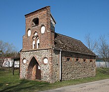
About one kilometer southeast of today's village, a late Slavic settlement was discovered in 1973 with about ten house floor plans, which are noticeable as dark discoloration of the ground. Nothing is known about a medieval settlement. The Hohenzollern bought Rheinsberg in 1734 and so the deserted Mark came into their possession. King Frederick the Great (ruled 1740 to 1786) gave Rheinsberg and the surrounding area to his brother, Prince Heinrich , in 1744. He had Heinrichsdorf set up in 1750 as a colony with seven farmers and two Büdners who did not have to pay taxes and were exempt from property tax. Around 1800, nine whole farmers and four residents (together 94 people) lived here and worked on agriculture. Between 1804 and 1807 a syringe house was built from field and brick , which was kept in the neo-Gothic style, but the fire extinguishing system could not prevent two large fires in the years 1826 and 1832, which practically destroyed the village. Only two farms remained. In 1907 a school was built for the children from Heinrichsdorf, Köpernitz and Heinrichsfelde , which was also used for church services .
In 1974 Heinrichsdorf had 243 inhabitants.
References and comments
- ^ A b Dieter Zühlke (arrangement) / collective of authors: Ruppiner Land: Results of the local history inventory in the areas of Zühlen, Dierberg, Neuruppin and Lindow . Berlin: Akademie-Verlag 1981. (Values of our homeland - local history inventory in the German D. Republic; 37). P. 71
- ↑ A wasteland is an uninhabited place.
literature
- Dieter Zühlke (arrangement) / collective of authors: Ruppiner Land: Results of the local history inventory in the areas of Zühlen, Dierberg, Neuruppin and Lindow . Berlin: Akademie-Verlag 1981. (Values of our homeland - local history inventory in the German D. Republic; 37)
Coordinates: 53 ° 3 ' N , 12 ° 57' E
