
Blumenstein BE
| BE is the abbreviation for the canton of Bern in Switzerland and is used to avoid confusion with other entries of the name Blumenstein . |
| Flower stone | |
|---|---|
 |
|
| State : |
|
| Canton : |
|
| Administrative district : | Tuna |
| BFS no. : | 0922 |
| Postal code : | 3638 |
| Coordinates : | 606 255 / 176 662 |
| Height : | 659 m above sea level M. |
| Height range : | 630–2100 m above sea level M. |
| Area : | 15.52 km² |
| Residents: | 1246 (December 31, 2018) |
| Population density : | 80 inhabitants per km² |
| Website: | www.blumenstein.ch |
 Blumenstein from the south, seen from the Walalp ridge |
|
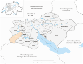
| Location of the municipality | |
  |
|
Blumenstein is a municipality in the Thun administrative district in the canton of Bern in Switzerland .
geography
The municipality is the westernmost municipality in the administrative district of Thun. It is located on the north side of the Stockhorn chain in the uppermost part of the Gürbetal and in the Stockental . The Gürbe flows through its northern edge . The community consists of two parts: on the one hand, Inner-Blumenstein with the village of Blumenstein and the hamlets of Eschli , Gassen , Rüdeli and Wäsemli ; on the other hand from the hamlets of Bodenzingen , Lochmannsbühl and Reckenbühl (together called Ausser-Blumenstein) and the formerly independent municipality of Tannenbühl . There are also numerous groups of houses and individual farmsteads. Half of the municipal area of 1552 hectares, 49.6%, is used for agriculture. Another 38.0% are forest and wood and 8.5% are unproductive areas (like rocks) - especially in the mountain area towards the Stockhorn chain. And only 3.9% of the community area is built over. The community lies on the edge of the Gantrisch Regional Nature Park .
population
| year | Residents |
|---|---|
| 1764 | 443 |
| 1850 | 1,077 |
| 1900 | 814 |
| 1910 | 814 |
| 1930 | 955 |
| 1941 | 965 |
| 1960 | 1,121 |
| 1980 | 1,167 |
| 2000 | 1,202 |
| 2005 | 1,170 |
The population rose sharply between 1764 and 1850 (1764-1850: + 143.1%). Then it fell sharply until 1900 as a result of emigration to the industrial areas (in and around Thun) (1850–1900: −24.4%). Between 1910 and 1930 and between 1941 and 1960 there were two major growth spurts, so that the population reached a new high (1910–1960: +37.7%). The number of residents decreased a little by 1980, but then rose to a new high of 1,202 residents by 2000. Since then the population has been fairly stable. The majority of the population (60%) are between 21 and 64 years old.
languages
The population speaks a high Alemannic dialect in everyday life , which is one of the dialects of Bern German . At the last census in 2000, 97.15% said German, 1.76% Albanian and 0.34% French were the main languages.
Religions - denominations
In earlier times all residents were members of the Evangelical Reformed Church. This has changed due to immigration from other regions of Switzerland and abroad as well as church resignations. On December 31, 2007, the religions were made up as follows: 82% Reformed, 6% Catholic, 10% non-denominational and 2% other (Muslims and some gave no information about their creed). The Muslims are almost exclusively of Albanian origin.
Origin - nationality
The proportion of foreign immigration is low. As of December 31, 2007: residents 1176 of which 39 residents are foreigners. Of the 1,139 Swiss nationals, ten had more than one nationality. The few immigrants come from Serbia-Montenegro, Macedonia (in both cases mostly Albanians), Germany, Italy, Spain, Sri Lanka and the Netherlands.
politics
Regula Hänni is mayor (as of 2019).
The voting shares of the parties in the 2015 National Council election were: SVP 51.5%, BDP 13.7%, SP 11.4%, EVP 8.0%, EDU 4.1%, GPS 3.4%, FDP 3.0 %, glp 2.6%, CVP 0.7%.
economy

The village was dominated by agriculture until well into the 20th century. In addition, the spa business in the climatic health resort of Blumenstein-Bad played an important role. Grain and potato cultivation dominated agriculture until the 19th century, before cattle farming began on a large scale. Today (as of 2000) there are still 87 employees working in the 32 farms. Industry and small businesses offer 153 people a job, while 119 people find a livelihood in the 27 service companies. Numerous people from Blumenstein are commuters these days - especially to the city of Thun.
tourism

In earlier times, Blumenstein-Bad in particular attracted strangers. Today it is mainly hikers and cyclists who come to Blumenstein. In 2008 the municipality refused to join the Gantrisch Regional Nature Park.
traffic
Blumenstein is not on any railway line, but is well connected to the public transport network by bus. Lines 3, 50 and 51 of the STI run to and from Thun . Line 53 to and from Seftigen train station during the day.
Blumenstein is on the road from Wimmis to Seftigen, but also has good road connections to Thun. The closest motorway connections are Thun-Süd and Thun-Nord on the A6 .
history
The community was settled relatively late. The rule Bluomenstein sold Peter von Raron on May 18, 1348 to the city of Bern . The lower jurisdiction had different families. First the gentlemen von Blumenstein , lastly those of Wattenwyl . A member of the latter family sold his rulership rights to Bern in 1642. Initially, the place belonged to the Seftigen district court , from 1658 to 1798 to the Thun office . From 1798 to 1803, Blumenstein was part of the Helvetian district of Oberseftigen . Since then, the community has belonged to the district of Thun . The hamlet of Tannenbühl was an independent municipality until it was incorporated in 1859 (1850: 385 inhabitants).
Attractions
The group of buildings on the Fallbach with the church (formerly St. Nicholas), the rectory, the cow's house and the Pfrundscheune are worth seeing. This assembly is one of the structures of national importance. Various old farmhouses are also worth seeing because of their own style.
Personalities
- Ján Cibuľa (* 1932–2013), doctor, politician, founding president of the International Roma Union
- Nico Müller (racing driver) (born February 25, 1992), racing driver DTM Audi Sport
literature
- Walter Rothacher: Chronicle of the church and the village of Blumenstein. 4th edition, self-published, Blumenstein 1981.
- Doris Amacher: Blumenstein and Pohlern. A hiking guide to rural architecture. (Swiss Art Guide, Volume 666/667). Ed. Society for Swiss Art History GSK. Bern 1999, ISBN 3-85782-666-5 .
Web links
- Official website of the municipality of Blumenstein
- Anne-Marie Dubler : flower stone. In: Historical Lexicon of Switzerland .
- Anne-Marie Dubler: Tannenbühl. In: Historical Lexicon of Switzerland .
Individual evidence
- ↑ Permanent resident population from STAT-TAB of the BfS , municipalities see also regional portraits 2020 on bfs.admin.ch, accessed on May 29, 2020
- ↑ Results of the community of Blumenstein. State Chancellery of the Canton of Bern, October 18, 2015, accessed on October 30, 2016 .
Amsoldingen | Flower stone | Buchholterberg | Burgistein | Eriz | Fahrni | Forst-Längenbühl | Gurzelen | Heiligenschwendi | Heimberg | Hilterfingen | Homberg | Horrenbach beeches | Oberhofen am Thunersee | Oberlangenegg | Pohlern | Reutigen | Juicy | Sigriswil | Steffisburg | Stocken-Höfen | Teuffenthal | Thierachern | Tuna | Uebeschi | Uetendorf | Unterlangenegg | Uttigen | Wax thorn | Wattenwil | Zwieselberg
Former municipalities: Forst | Goldiwil | Höfen bei Thun | Kienersrüti | Längenbühl | Stocking down | Oberstocken | Schwendibach | Strättligen | Tannenbühl | Thung snow
Canton of Bern | Administrative districts of the canton of Bern | Municipalities of the Canton of Bern