
Augstmatthorn
| Augstmatthorn | ||
|---|---|---|
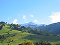
 Augstmatthorn of Habkern seen from |
||
| height | 2136 m above sea level M. | |
| location | Bernese Oberland , Switzerland | |
| Mountains | Bernese Prealps | |
| Dominance | 5.14 km → Hohgant | |
| Notch height | 271 m ↓ Riedergrat | |
| Coordinates | 637 445 / 176 901 | |
|
||

The Augstmatthorn is a 2136 m above sea level. M. high summit in the Emmental Alps , a subgroup of the Bernese Pre-Alps . It rises in the central part of the approx. 25 km long Brienzergrat , which stretches from Harder Kulm near Interlaken via Augstmatthorn and Brienzer Rothorn to the Brünig Pass. The Augstmatthorn itself is a relatively little raised ridge peak in profile (seen from the north or south), which is about 1 km southwest at 2085 m above sea level. M. high, steeply rising from the ridge and therefore quite distinctive secondary peak, the Suggiture, is in front of it.
The Augstmatthorn falls within the hunting ban area of Oberried am Brienzersee .
Location and surroundings
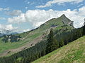
The Augstmatthorn is the local mountain of the mountain village Habkern on the north side and rises above the villages of Oberried and Niederried on the shores of Lake Brienz in the south. From the summit of the Augstmatthorn you have a good view to the south of the Eiger , Mönch and Jungfrau as well as Lake Brienz, which is 1573 m lower. The village of Habkern and the Hohgant can be seen in the north . A ski slope with a drag lift is in operation in Habkern in winter. On the Lombachalp there is a cross-country ski run in the direction of Hohgant.
The first ibex colony in the canton of Bern was established on the Augstmatthorn at the beginning of the 20th century and can be seen with binoculars from Habkern.
At the beginning of June 2013, a major debris flow started from the northwest flank of the Suggiture , which, in addition to damage to bridges, made some of the access roads to the ridge trail from Habkern impassable.
Routes
To climb the Augstmatthorn, you can park on the Lombachalp for a fee. It can also be approached from Brienz or the Harder Kulm.
Circular hike Lägerstutz – Augstmatthorn – Suggiture – Querweg – Lägerstutz
This hike is also possible with touring skis in winter.
- Time required: 3.5–4 hours
- Difference in altitude: 600 m
- Starting point: Habkern, Lombachalp
Harder – Horet – Suggiture – Augstmatthorn – Schwendallmi – Habkern
Ridge hike with a fantastic view
- Time required: 6 hours
- Difference in altitude: ascent 850 m, descent 1100 m
- Starting point: Harder Kulm
All hiking trails on the Brienzer Grat are signposted as mountain hiking trails (white-red-white markings, T2-T3 , the path is clearly recognizable throughout) and require surefootedness, especially the west climb to the Suggiture and the further path to the main summit. In the area, some particularly steep places are insured with steel cables, but this is not the case for the z. T. quite exposed ridge itself applies.
gallery

Augstmatthorn / Suggiture in October
Augstmatthorn / Suggiture with snow
Augstmatthorn with Suggiture (right) seen from the ridge from the southwest; below left the debris flow from June 2013

View from the Suggiture along the ridge to the Augstmatthorn main summit


literature
- Bernese Oberland East - the most beautiful valley and mountain hikes. Bergverlag Rother
- Hiking guide Bernese Oberland - circular hikes between lakes and glaciers. Kümmerly + Frey
- Jungfrau Region hiking book - walks in view of the four-thousand-meter peaks in the Oberland. Kümmerly + Frey