
Fiescher glacier
| Fiescher glacier | ||
|---|---|---|
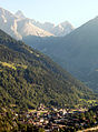
 Fiescher glacier from the south |
||
| location | Canton of Valais , Switzerland | |
| Mountains | Bernese Alps | |
| Type | Valley glacier | |
| length | 14.8 km (2011) | |
| surface | 37.01 km² (1993) | |
| Exposure | Nutrient area southeast, feeding area south | |
| Altitude range | 4180 m above sea level M. - 1681 m above sea level M. (2001) | |
| Ice volume | 3.84 ± 0.96 km³ (1993) | |
| Coordinates | 654 353 / 149 852 | |
|
||
| drainage | Weisswasser , Rhone | |

The Fiescher Glacier is a valley glacier on the south side of the Bernese Alps in the canton of Valais in Switzerland . With a length of 14.8 km it is the second longest glacier in the Alps after the neighboring Aletsch Glacier , but is comparatively narrow, so that in terms of area with 37 km² (1993) it is only the third largest in the Alps after the Aletsch and Gorner glaciers .
location
The Fiescher Glacier starts at around 4000 m above sea level. M. on the eastern slope of the Gross Fiescherhorn . After overcoming an altitude difference of 700 m for the first two kilometers, it only flows south-eastwards with a flat slope, flanked in the west by the Grünhorn ( 4044 m above sea level ) and Gross Wannenhorn ( 3906 m above sea level ), in the East from Finsteraarhorn ( 4274 m above sea level ). Small tributary glaciers flow in from both sides . At the southern foot of the Finsteraarrothorn ( 3530 m above sea level ) the system of the Studer and Galmi glaciers , which are 5 km long and are almost as wide as the Fiescher glacier, also flows from the east .

In its lower section, the Fiescher Glacier flows south through a deep valley between the Wannenhorn in the west and the ridge of the Wasenhorn in the east. In summer, when the layer of snow has melted, it presents itself here as a gray glacier, covered with the scree of the central moraines and the rocks that have slipped off the steep slopes. The glacier tongue is currently a little below 1700 m north of the castle (northern end of a rock bastion, also called Titter , in the lower part ). This is where the Weisswasser glacier stream emerges, which flows into the Rhone at Fiesch .
Finsteraarhornhütte
On the southwest slope of the Finsteraarhorn, around 100 m above the Fiescher glacier, the Finsteraarhornhütte of the Swiss Alpine Club SAC is located at 3,048 m above sea level. M. It is often used as a stopover extended several days glacier tours from the Jungfraujoch or the Lötschental to Grimselpass .
The Fiescher Glacier is not to be confused with the glacier north of the Fiescherhörner , which flows into the Lower Grindelwald Glacier, which the map also refers to as the Fiescher Glacier and which is also referred to as the Grindelwald-Fiescher Glacier to distinguish it from the Valais Fiescher Glacier.

Bellwald, Ried district in 1910 in front of the Gross Wannenhorn. On the left the Fiescher glacier.

Photo 100 years later: At this point nothing can be seen of the glacier.

The place Fiesch in 1911. The Fiescher glacier is clearly visible.
99 years later viewed from the same perspective.


Individual evidence
- ↑ a b Research Institute for Hydraulic Engineering, Hydrology and Glaciology (VAW) of the ETH Zurich (Ed.): Fieschergletscher. In: Swiss Glacier Measurement Network. ( ethz.ch , also as PDF , accessed on January 10, 2014).
- ↑ a b c Daniel Farinotti, Matthias Huss, Andreas Bauder, Martin Funk: An estimate of the glacier ice volume in the Swiss Alps. In: Global and Planetary Change. 68: 225-231, 2009 ( online ; PDF; 756 kB).
- ^ WGMS: Fluctuations of Glaciers Database. World Glacier Monitoring Service, Zurich 2013 ( DOI: 10.5904 / wgms-fog-2013-11 ), accessed on December 11, 2013
Web links
- Research institute for hydraulic engineering, hydrology and glaciology (VAW) of the ETH Zurich (publisher): Fieschergletscher. In: Swiss Glacier Measurement Network. ( ethz.ch , also as PDF ).
- The Fiescher Glacier on SwissEduc: Glaciers Online
- Interactive before and after comparison pictures of the Fiescher glacier
- Map section at map.geo.admin.ch