
Lower Grindelwald Glacier
| Lower Grindelwald Glacier | ||
|---|---|---|
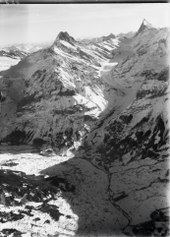
 The miserable remains of the Lower Grindelwald Glacier (dark, polluted areas) with the glacier edge lake with the white-blue Ischmeer above. The Fiescherwand and the Fiescherhörner (4049 m) are enthroned above it. On the far right a nameless summit (2251 m) and the Ostegg (2710 m), the easternmost foothills of the Eiger. On the left the green Bänisegg. The original upper tributary of the Lower Grindelwald Glacier would have been directly behind it, but this connection no longer exists. Taken from the Bäregghütte (1772 m) (July 2009). |
||
| location | Canton of Bern , Switzerland | |
| Mountains | Bernese Alps | |
| Type | Valley glacier | |
| length | 9 km (1975) | |
| surface | 21.71 km² (1975) | |
| Exposure | North | |
| Altitude range | 4100 m above sea level M. - 1090 m above sea level M. (1975) | |
| Tilt | ⌀ 19 ° (34%) | |
| Coordinates | 647 328 / 157 770 | |
|
||
| drainage | Weisse Lütschine , Schwarze Lütschine , Aare , Rhine | |


The Lower Grindelwald Glacier was the western of the two glaciers that fed the Grindelwald valley, namely the (formerly) further out of the valley into the valley. The Weisse Lütschine (not to be confused with that of Lauterbrunnen) arose from him . Today only its former tributaries exist, which have their own names.

Overview
Until recently, the name Unterer Grindelwald Glacier was used to describe both the eponymous tongue of the glacier described in the introduction and the entire glacier system that nourished this tongue. This consisted of two mostly equally powerful ice streams that united in the area of the Bänisegg to form the actual Lower Grindelwald Glacier. Both the western and the eastern influx are simply called the Eismeer or the dialect Ischmeer . For a long time, the western arm was also known as the Fiescher Glacier or, to distinguish it from the Valais Fiescher Glacier, as the Grindelwald-Fiescher Glacier . If one of the two tributaries was viewed as the main stream, then the eastern of the two tends to come down from the Finsteraarjoch (panorama picture). However, this view has been questionable since the 1950s insofar as little ice has passed the Bänisegg from this arm of the glacier, so that the tongue of the Lower Glacier has almost exclusively come from the western arm (Grindelwald-Fiescher Glacier, now called Ischmeer) was supplied.
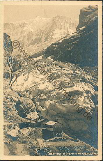
The Lower Glacier formed a wide glacier basin from the Bänisegg to above the Bäregg. Alpe Stieregg was located on its right bank in the direction of the river, just south of the Bäregg. Below (north) the Bäregg, it flowed through the glacier gorge as a narrow tongue, which can be visited from Grindelwald for a fee. The lower part of the glacier gorge cuts through two prominent rock ledges, the so-called upper and lower Schopffelsen. These paragraphs are clearly visible in the first picture of the history of the glacier at the bottom of the picture. Today the entrance to the gorge is at the foot of the lower Schopffelsen (picture and painting, bottom right).
The accelerated retreat of all parts of the glacier, especially since around the year 2000, initially led to the eastern arm of the glacier below the Bänisegg being completely separated from the rest of the glacier. Since around 2012, the supply from the western arm (Fiescher Glacier) has also dried up, so that the remaining ice of the Lower Glacier - in the area down the valley of the Bänisegg - has now turned into dead ice. With the further melting of the dead ice, his room is gradually occupied by a lake that was created in 2006 by a rock fall across from the Bäregg.
The tongue that was mainly called the Lower Grindelwald Glacier has disappeared; the two earlier tributaries each formed their own tongue above the Bänisegg. Only the future can tell whether the name Lower Grindelwald Glacier will continue to be used in the future for the former eastern arm, or whether it will - as the name Bodengletscher near Zermatt already described - describe a historical glacier that no longer exists today.
history


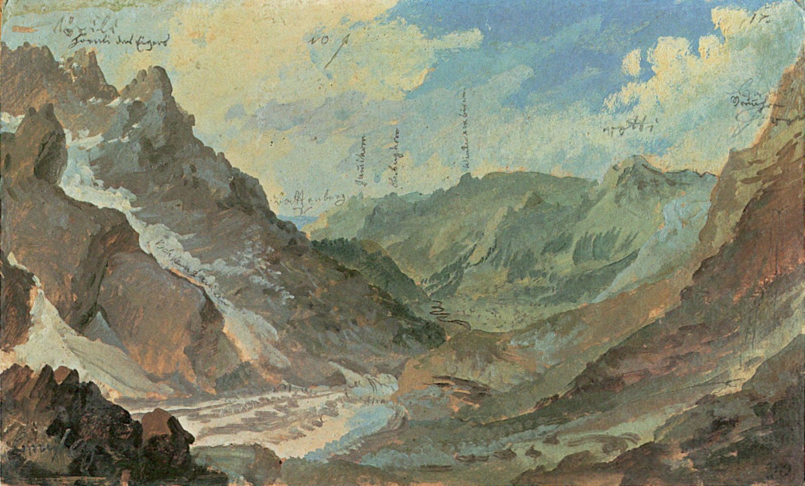
Beginning with the cooling at the end of the Middle Ages (1500), the so-called Little Ice Age , the Lower Grindelwald Glacier flowed over the glacier gorge down into the valley of Grindelwald. There part of the village had to be relocated around 1600 because the glacier ran over one house after the other. Until the middle of the 18th century it withdrew again over the Schopffelsen (picture right). Marble mining began around 1740 on the right edge of the tongue . Around 1770 the glacier advanced strongly and reached the valley floor in the area of today's hotel «Gletscherschlucht». The marble quarry was also run over by the glacier. Caspar Wolf documented this approach very realistically in the painting at the bottom right as well as in the one at the bottom («Art»). The glacier, which ends with spectacular ice towers (so-called Séracs ), became the main tourist attraction of the Grindelwald Valley for decades up to around 1900 and one of Switzerland's main attractions. Around 1850 the glacier advanced even further and in 1855 again reached a high level, similar to that of 1600. At that time, it flowed from today's entrance to the glacier gorge for about 500 m in the direction of Grindelwald-Grund. It was the only Alpine glacier that reached below 1000 m above sea level. M. flowed down. In 1863 the Bern-based company Schegg & Böhlen received a concession for commercial ice mining. Then a road was built from Grindelwald-Grund to the tongue of the glacier. The ice blocks were transported to the Bödelibahn in Interlaken and exported to Paris as a coolant. In 1864, for example, 17,473 quintals of ice were extracted. With the advent of cooling units and the First World War , the mining and export of glacier ice ended in 1914.
The glacier was severely torn and in summer did not allow ascent to the area above Bäregg and Stieregg, which was known as the “Lower Eismeer” or (in the local dialect ) “Unders Yschmeer”. The access to the Bäregg and the alpine pastures further into the valley already followed today's route. The first refuge in the Bernese Oberland was built on the Bäregg in 1823 , and the Eismeer Hotel in 1858 . Above the Bäregg the glacier was practically flat (sea of ice!) And allowed a smooth transition and even cattle drive to the pastures of Kalli and Zäsenberg opposite the confluence of the Fiescher glacier . In 1857 the Mönch was first climbed on this way .
The glacier melted sharply in the following years. Around 1864 he released the earlier marble quarry, where Edmund von Fellenberg was the first to find rose-colored marble again. Here dismantling was resumed immediately. In 1869 the Berglihütte was built in the area of the upper Fiescher glacier . Around 1870 the glacier left the Grindelwald valley floor and around 1875 it released the so-called lower Schopffelsen, where today a bridge leads over the lower part of the glacier gorge. By 1882 he had withdrawn about a kilometer, counted from the high point in 1855, to about 150 m southeast of today's bridge. There the tongue remained stationary until 1897 and then withdrew approx. 200 m further into the gorge, also releasing the upper Schopffelsen. There it remained more or less stationary from 1905 to 1932. From Nellenbalm a path was built to the left of the gorge on the upper Schopffelsen, as was the marble quarry to the right of the gorge. So the tongue was easily accessible from the valley until the 1930s. On July 25, 1905, the Jungfrau Railway opened the section to the Arctic Ocean. This enabled significantly easier access to the Berglihütte and, for daring skiers, the Arctic Ocean descent over the glacier tongue to Grindelwald. In 1908 the Konkordia hut was built from the Eismeer station .
Since the mid-1930s, the tongue of the glacier has continuously retreated by a further 800 m to the upper entrance to the gorge near the Bäregg. The direct access to the glacier from the valley gradually became more difficult. At the same time, the lower Arctic Ocean in the area above the Bäregg sank by over 130 m (compared to 1855) and left steep moraines behind. The transition towards Kalli and Zäsenberg became more and more complex and dangerous. From around 1970 to 1995 the glacier tongue remained essentially stationary below the Bäregg - with a small interlude around 1980, when fall ice from the strongly advancing Kallifirn extended the tongue by 125 m into the gorge within a year. Exact measurements could not be carried out on her because the tongue in the gorge was not accessible. The lower glacier remained the one with the lowest tongue end of all alpine glaciers, which, deep down in the gorge, was found at 1090 m.

The melting of the glacier , which began around 1998, has made the eastern flank of the Hörnli on the Eiger opposite the Bäregg very unstable. Therefore, in July 2006, a total of 2 million cubic meters of rock fell onto the glacier and a 250,000 m³ lake formed. On the side of the Mattenberg , the moraine collapsed in 2005 right up to the Stieregghütte , which was then abandoned and burned down. She threatened to fall on the remains of dead ice in the glacier basin. Instead of the Stieregghütte, the Bäregghütte was built.
Because the lake at the tongue occasionally empties spontaneously, the entire Lütschinental area up to Lake Brienz is at risk of flooding. Therefore, in 2009 a tunnel was built at the exit of the glacier gorge, through which the lake can be drained in a controlled manner. The water is directed around 800 meters around the dam and then falls into the Lütschine in a 140-meter high waterfall.
As the inflow dwindled from above, the ice in the basin between Bänisegg and Bäregg sank ever further and can now only be distinguished from the surrounding moraine debris where it is exposed by the lake.
For their part, the two newly formed tongues are about to tear apart on the steep steps of the “Rote Gufer” and the “Heissen Platte” (or “Heissi Blatta”) and turn the parts above the Bänisegg into dead ice.
Arctic Ocean descent
In 1907 the Jungfrau Railway ran for the first time in winter - from the Eigergletscher station and to the then terminus Eismeer. From there, skiers of the Grindelwald Ski Club opened the spectacular descent over the Fiescher Glacier, the Zäsenberg, the part of the Eismeer coming from the Schreckhorn and over the tongue of the Lower Grindelwald Glacier, which at that time still reached almost to the upper Schopffelsen, to Grindelwald. In some cases, this route was also used the other way around as a ski tour , with the return journey by Jungfrau Railway.
This descent was very popular until the 1950s, but then became more and more dangerous and only feasible in snowy years. Today it is no longer possible because from the glacier tongue there is no longer any access to the bands that lead through or above the glacier gorge to Grindelwald.
Mountain trails
Orographically to the right over the glacier gorge to the Bäregg and along the lower glacier and further above along the Eismeer, the scenic hut path runs to the Schreckhornhütte of the SAC (T 4) or to the place of the former Strahlegghütte (L). This has to be relocated upwards again and again because of the gradually collapsing side moraines. The former direct access to the glacier tongue to the left above the gorge was prepared with steel cables in the 1980s, but has been closed for many years due to the further retreat of the glacier and is now life-threatening due to the rock movements mentioned. The routes that crossed the glacier, for example over the Kalli to the Berglihütte or on the Zäsenberg opposite the Bänisegg, have hardly been used for many years.
art

The glacier was painted a. a. by the Swiss artist Caspar Wolf 1774 and 1777. These pictures show an advance phase, which is often characterized by tearing the tongue ends in ice towers ( Séracs ). The glacier is about to become almost as big as it was around 1600. From the perspective of these images, the glacier has not been visible since around 1900.
Individual evidence
- ↑ a b c WGMS: Fluctuations of Glaciers Database. World Glacier Monitoring Service, Zurich 2013 ( DOI: 10.5904 / wgms-fog-2013-11 ), accessed on December 11, 2013
- ^ Research institute for hydraulic engineering, hydrology and glaciology (VAW) of the ETH Zurich : Lower Grindelwald glacier. In: Glacier Natural Hazards. ( ethz.ch ( page no longer available ), also as a PDF ( page no longer available )).
Web links
- Webcam image of the tongue
- gletschersee.ch webcam and current location on the glacier lake
- Images, especially about the landslide in 2006, are online on Glaciers
- Research Institute for Hydraulic Engineering, Hydrology and Glaciology (VAW) of the ETH Zurich : Lower Grindelwald Glacier. In: Glacier Natural Hazards. ( ethz.ch ( page no longer available ), also as a PDF ( page no longer available )).
- Research institute for hydraulic engineering, hydrology and glaciology (VAW) of the ETH Zurich (publisher): Unterer Grindelwaldgletscher. In: Swiss Glacier Measurement Network. ( ethz.ch , also as PDF ).
- Lower glacier above the marble quarry, around 1900
- Caspar Wolf: View from the Bänisegg to the Stieregg, 1774