
Black Lütschine
| Black Lütschine | ||
 The Black Lütschine near Grindelwald |
||
| Data | ||
| Water code | CH : 501 | |
| location |
Bernese Alps
|
|
| River system | Rhine | |
| Drain over | Lütschine → Aare → Rhine → North Sea | |
| source | in the area of the Upper Grindelwald Glacier 46 ° 37 ′ 33 ″ N , 8 ° 6 ′ 36 ″ E |
|
| Source height | approx. 2600 m above sea level M. | |
| confluence | at Zweilütschinen with the Weisse Lütschine to Lütschine coordinates: 46 ° 38 '2 " N , 7 ° 53' 54" E ; CH1903: 635.21 thousand / 164841 46 ° 38 '2 " N , 7 ° 53' 54" O |
|
| Mouth height | 646 m above sea level M. | |
| Height difference | approx. 1954 m | |
| Bottom slope | approx. 95 ‰ | |
| length | approx. 20.6 km | |
| Catchment area | 179.89 km² | |
| Discharge A Eo : 179.89 km² at the mouth |
MQ Mq |
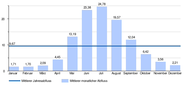
9.67 m³ / s 53.8 l / (s km²) |
The Schwarze Lütschine is an approximately 20 kilometer long river in the Bernese Oberland . At Zweilütschinen it merges with the Weisse Lütschine to form the Lütschine .
geography
course
The most important source of the Black Lütschine is the Upper Grindelwald Glacier and some streams that arise above this glacier and flow into their valley.
At an altitude of about 1600 m above sea level. M. to 1700 u m. M. currently the glacier ends and the Schwarze Lütschine now runs freely through the valley, where some smaller streams continue to flow towards it. Shortly after reaching the valley up to the Grosse Scheidegg you will flow on the right side of the Briggbach at about 1170 m above sea level. M. to. Almost a kilometer later you hurry to 1070 m above sea level. M. the Bärgelbach to. Somewhat downstream, the Black Lütschine reaches Grindelwald , where it is 1020 m above sea level. M. again takes up the Milibach from the right .
A little outside the settlement area, but still near Grindelwald, it now unites at an altitude of 958 m above sea level. M. with the similarly sized White Lütschine from the left, but keeps her name. Then it reaches the settlement area of Grindelwald again where the small Sandbach joins from the left . A little later it is fed by the Wärgischtalbach on the same side .
After this time from the right of the Mälbaumgraben at 925 m above sea level. M. has flowed into the river, it is now finally leaving the settlement area of Grindelwald. At Schwendi other small streams flow and shortly after the place the Black Lütschine becomes at an altitude of 910 m above sea level. M. strengthened from the right side by the Schwendibach . Above Burglauenen , the Fallbach flows in from the right . Within Burglauenen there are other small streams and the Blindlibach from the right ( 835 m above sea level ).
After a relatively steep section, the stream now reaches the village of Lütschental , where the Ryschbach ( 740 m above sea level ) and the Stiglisbach ( 720 m above sea level ) flow from the right, as well as some smaller streams from the other side of the valley. In Lauenen lead from the right side of Glattbach and from the left of the Furibach and little attention from the right Chien Bach . Until the river reaches Gündlischwand ( 660 m above sea level ), it takes in further small streams from both sides of the valley.
At Zweilütschinen the Schwarze Lütschie finally unites with the White Lütschine coming from the left from the Lauterbrunnen valley to form the Lütschine.
Its 20.6 km long run ends about 1954 meters below its source, so it has a mean bed gradient of 95 ‰.
Catchment area
The approximately 180 km² catchment area of the Black Lütschine lies in the Bernese Alps and is drained to the North Sea via the Lütschine, the Aare and the Rhine
The highest point in the catchment area is 4092 m above sea level. M. , the mean height of the catchment area is 2054 m above sea level. M. and the minimum height is 646 m above sea level. M.
In the catchment area are the Eiger , Mönch , Lauteraarhorn , Schreckhorn and the Wetterhorn above the Grosse Scheidegg.
The catchment area consists of 20.4% wooded area , 30.0% agricultural area , 1.8% settlement area , 21.8% glacier / firn, 0.5% water area and 25.5% % from unproductive areas.
Area distribution

Hydrology
At the confluence of the Black Lütschine with the Weisse Lütschine, their modeled mean flow rate (MQ) is 9.67 m³ / s. Her discharge regime type is a-glacio-nival and her discharge variability is 13.
Web links
Individual evidence
- ↑ a b c Geoserver of the Swiss Federal Administration ( information )
- ↑ a b c d Topographical catchment areas of Swiss waters: sub-catchment areas 2 km². Accessed February 1, 2020 .
- ↑ "Hidden behind the mean values" - the variability of the discharge regime , p. 7
- ↑ The discharge variability describes the extent of the fluctuations in the mean discharge of individual years around the long-term mean discharge value.