
Äbeni Flue
| Äbeni Flue | ||
|---|---|---|
 Äbeni Flue from the north, from the Virgin . Directly behind the nest horn . |
||
| height | 3961 m above sea level M. | |
| location | Canton border Bern / Wallis , Switzerland | |
| Mountains | Bernese Alps | |
| Dominance | 1.2 km → Gletscherhorn | |
| Notch height | 198 m ↓ Gletscherjoch | |
| Coordinates | 639 525 / 150869 | |
|
||
| First ascent | August 27, 1868 by Thomas Lioyd Murray Browne with Peter Bohren and Peter Schlegel via today's normal route | |
| Normal way | Southwest flank and southeast ridge ( difficulty L ) | |
 Icy north face of the Äbeni Flue between Gletscherhorn and Mittaghorn on a photo by Eduard Spelterini |
||

The Äbeni Flue (also Ebnefluh ) is 3961 m above sea level. M. high mountain in the Bernese Alps . The border between the Swiss cantons of Bern and Valais runs over its summit .
Description and geographic location
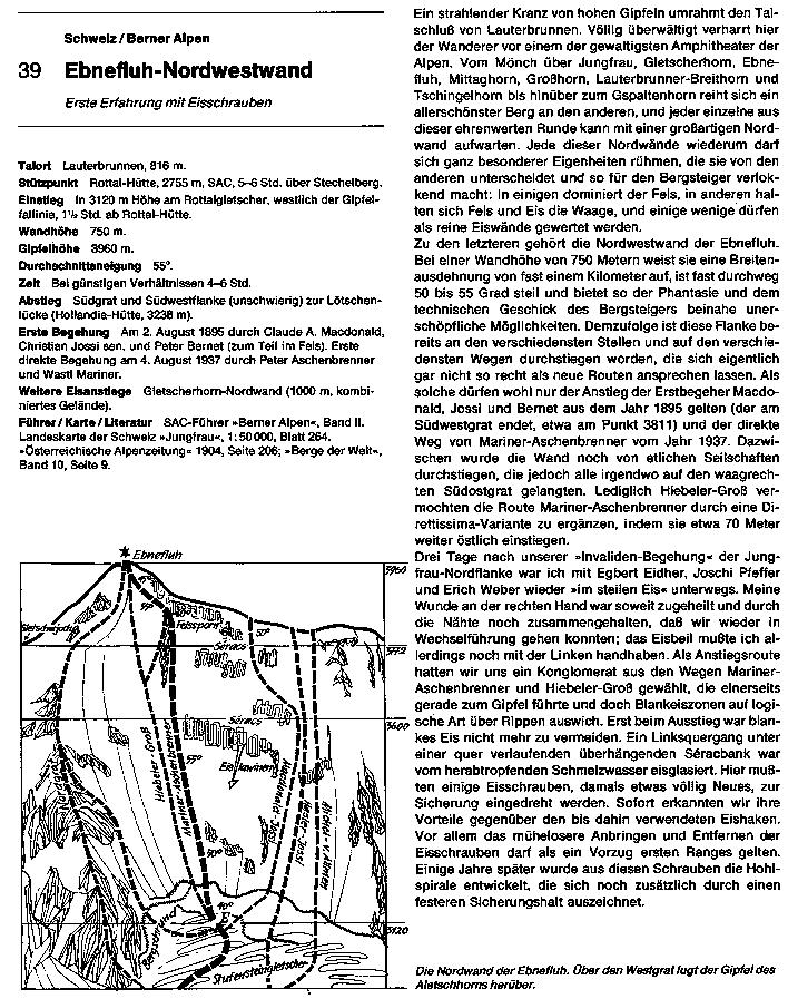
The Äbeni Flue forms a broad firn peak, which drops to the north in steep walls over 2500 meters into the Lauterbrunnen valley. The southern slopes are glaciated and lead relatively flat to the Great Aletschfirn . A ridge leads east to 3983 m above sea level. M. high Gletscherhorn , from which a ridge leads to the northern Jungfrau . To the southwest, a ridge leads to the Mittaghorn , Grosshorn and Breithorn . The Aletschhorn rises south above the Great Aletschfirn with its mighty north face.
Summit routes
The normal route leads over the southwest flank and the southeast ridge to the summit. The starting points are either the Hollandiahütte or the Konkordiahütte . The difficulties here are L according to the SAC mountain and high-altitude tour scale . In winter, this route is often used as a ski tour .
The north face of the Äbeni Flue is a classic ice wall that is climbed relatively often. It has a height of about 900 meters and a steepness of 50 to 55 ° (overall difficulty SS-) and is objectively relatively safe. Despite the general depletion , conditions have often been good in the past few years. The starting point is the Rottalhütte at 2755 m above sea level. M.
Plane crash
On April 12, 2007, a German armed forces tornado crashed into the north face of the Äbeni Flue during a navigation flight. The pilot was killed and the weapons system officer survived seriously injured. Investigations showed that the cause of the accident was human error - the pilot chose an unsuitable flight tactic: Swiss pilots avoid the Lauterbrunnen Valley because of the large number of paragliders , and the aircraft that had been refueled shortly before in Emmen (70 km as the crow flies) was too heavy to be safe Fly over the mountain quickly enough to gain altitude.
Web links
- Detailed report of an ascent of the north face
- Erich Vanis : In the steep ice. Ebnefluh Northwest Face (GIF)
Individual evidence
- ↑ Summer 2003 and the consequences: Effects of global warming on classic routes in the Valais and Bernese Alps. An overview of the changes to selected routes (PDF; 201 kB)
- ↑ Ueli Mosimann: Alpine tours in the Bernese Alps - From the Sanetsch Pass to the Grimsel . SAC-Verlag, 1999, pp. 290/291.
- ↑ sda / Reuters: Bundeswehr tornado crashed in Switzerland. NZZ, April 13, 2007, accessed on March 27, 2018 .
- ↑ VBS media information. April 7, 2007, archived from the original on March 15, 2016 ; Retrieved February 20, 2011 .
- ↑ The investigation into the tornado crash is complete. Senior Audit - Military Justice, February 14, 2008, accessed January 11, 2016 .
- ↑ Tornado pilot disregarded advice. In: look. April 15, 2007, accessed April 4, 2019 .