Limpach (river)
|
Limpach upper course name: Schwarzbach |
||
|
The Limpach below Kräiligen near Bätterkinden |
||
| Data | ||
| Water code | CH : 796 | |
| location | Canton of Bern , Canton of Solothurn ; Switzerland | |
| River system | Rhine | |
| Drain over | Emme → Aare → Rhine → North Sea | |
| source | in the forest Schattseite Hole in Ottiswil 47 ° 4 '46 " N , 7 ° 20' 58" O |
|
| Source height | 545 m above sea level M. | |
| muzzle | near Bätterkinden in the Emme coordinates: 47 ° 9 '36 " N , 7 ° 32' 47" E ; CH1903: 608168 / 223239 47 ° 9 '36 " N , 7 ° 32' 47" O |
|
| Mouth height | 456 m above sea level M. | |
| Height difference | 89 m | |
| Bottom slope | 4.6 ‰ | |
| length | 19.3 km | |
| Catchment area | 78.4 km² | |
| Discharge at the Kyburg-Buchegg A Eo gauge : 72.9 km² |
NNQ (2013) MNQ 2013–2017 MQ 2013–2017 Mq 2013–2017 MHQ 2013–2017 HHQ (2017) |
90 l / s 720 l / s 930 l / s 12.8 l / (s km²) 1.48 m³ / s 38.61 m³ / s |
The Limpach is a 19-kilometer left tributary of the Emme in the Swiss cantons of Bern and Solothurn . It drains a section of the Mittelland and belongs to the catchment area of the Aare and Rhine .

geography
The source of the Limpach lies at 545 m above sea level. M. in the Schatthole forest between Ottiswil and Ammerzwil in the municipality of Grossaffoltern . It passes Ottiswil and at Scheunenberg near Wengi on the western edge of the Limpach valley takes on the roughly equal Golihuebbach from the right . The Limpach now runs dead straight in a channel channel through the Limpachtal on a section of around 9 km. During trade fairs , the creek crosses from the canton of Bern for a short distance to the Solothurn area, after which it forms the canton border between Bern and Solothurn almost to its confluence.
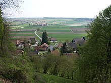
The Limpachtal is an on average 470 m above sea level. M. located valley depression that separates the Bucheggberg in the north from the heights of the Rapperswil plateau in the south. It is 13 km long and has a completely flat valley floor 1 to 2 km wide. The valley basin is filled with clayey silts , which over time have been removed from the surrounding heights; above it lies a thick layer of peat .
At the level of the town of Limpach , the stream takes a north-easterly direction of flow. Soon afterwards it reaches the alluvial zone of the Emme and runs along the southern foot of the Altisberg (northeastern foothills of the Bucheggberg) through the Bätterkinder district of Kräiligen , before it is halfway between Bätterkinden and Biberist at 458 m above sea level. M. flows into the Emme.
Hydrology
The gradient is just 0.46% along the entire stretch of the river. The Limpach is characterized by a pluvial flow regime , with the mean flow rate at Kyburg-Buchegg being 930 l / s. From the south, several streams flow from the Rapperswil hill country to the Limpach, namely the Hoschwerzibach , the Messibach and the Mülchibach .
The water quality of the stream is severely impaired by the intensive agricultural use of the areas in the catchment area; the ammonium and nitrate levels are well above the level required for a healthy biological situation.
use
The Limpach Valley used to be an extensive swamp area in which peat was cut from time to time.
Bach correction
As early as the 15th century, the first measures to clear the area in the Limpachtal began. Some sections of the Limpach were canalized from 1746. A cross-cantonal improvement of the Limpach valley was carried out from 1939 to 1951 in order to gain new cultivated land. Since then, the entire course of the Limpach has been canalized and straightened, the river no longer has any natural sections. Today only the moss between Wengi and Scheunenberg reminds of the former moor landscape.
literature
- Hans Stähli: The amelioration of the Limpach valley 1939–1951, o. O. 1953.
Web links
Individual evidence
- ↑ a b c d Geoserver of the Swiss Federal Administration ( information )
- ^ Limpach - Kyburg-Buchegg. (PDF) In: Office for the Environment of the Canton of Solothurn. Retrieved August 6, 2018 .

