
Aetingen
| Aetingen | ||
|---|---|---|
 |
||
| State : |
|
|
| Canton : |
|
|
| District : | Bucheggberg | |
| Residential municipality : | Buchegg | |
| Postal code : | 4587 | |
| former BFS no. : | 2442 | |
| Coordinates : | 605 079 / 220263 | |
| Height : | 480 m above sea level M. | |
| Area : | 2.85 km² | |
| Residents: | 297 (December 31, 2013) | |
| Population density : | 104 inhabitants per km² | |
| Website: | www.buchegg-so.ch | |
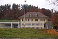
_281.JPG) Aetingen village center with church |
||
| map | ||
|
||


Aetingen , rarely also written Ätingen , was a political municipality in the Bucheggberg district of the canton of Solothurn in Switzerland until December 31, 2013 . On January 1, 2014, Aetingen merged with the former municipalities of Aetigkofen , Bibern , Brügglen , Gossliwil , Hessigkofen , Küttigkofen , Kyburg-Buchegg , Mühledorf and Tscheppach to form the new municipality of Buchegg .
geography
Aetingen lies at 480 m above sea level. M. , 8.5 km south-southwest of the canton capital Solothurn (linear distance). The street village extends slightly higher at the southeast foot of the Bucheggberg , on the edge of the Limpach valley , in the Solothurn Mittelland .
The area of the community area of 2.9 km² covers a section in the southwest of the Solothurn Mittelland. The south-eastern border runs along the canalised Limpach. From here the municipality extends to the northwest over the to 465 m above sea level. M. lying agriculturally intensively used plains of the Limpach valley and the subsequent molasse heights of the Bucheggberg, where on the slope of the Chalgen at 620 m above sea level. M. the highest point of Aetingen is reached. In the Aetingen area, the densely forested south-eastern slope of the Bucheggberg is subdivided by several stream valleys. In 1997, 6% of the municipal area was in settlements, 42% in forests and woodlands, 49% in agriculture and a little less than 3% was unproductive land.
Aetingen includes the main part of the village of Brittern ( 472 m above sea level ) on the northern edge of the Limpach valley at the foot of the Britternhubel and a few individual farms. Neighboring communities of Aetingen were until December 31, 2013 Unterramsern , Mühledorf , Brügglen and Kyburg-Buchegg in the canton of Solothurn and Bätterkinden and Fraubrunnen in the canton of Bern .
population
With 297 inhabitants (as of December 31, 2013), Aetingen was one of the small communities in the canton of Solothurn. 96.3% of the residents are German-speaking, 2.6% French-speaking and 0.7% speak English (as of 2000). The population of Aetingen was 266 in 1850 and 303 in 1900. In the course of the 20th century, the population fluctuated between 290 and 320 inhabitants, before a slight overall decline in population was recorded in the second half.
economy
Aetingen was a predominantly agricultural village until the second half of the 20th century . Even today, arable farming and fruit growing as well as cattle breeding have an important place in the income structure of the population. Further jobs are available in local small businesses and in the service sector, including in a horticultural company and in a joinery. Aetingen is the location of a golf course . In the last few decades the village has developed into a residential community with the development of new residential zones on the slope above the town center. Many employed people are therefore commuters who work mainly in the Solothurn and Bern regions.
traffic
The community is located away from the larger thoroughfares on a connecting road from Lohn-Ammannsegg along the southern foot of the Bucheggberg to Messen . Aetingen is connected to the public transport network through a Postbus course , which serves the route from Bätterkinden to Messen, and the Bucheggberg on- call bus .
history
The municipality of Aetingen was already settled during Roman times, which could be proven by some finds from the 2nd century AD in the area of the church. In the early Middle Ages there was a previously unexplored refuge near the old castle above the village.
The place was first mentioned in a document in 1267 under the name Etinge . The names Hättingen (1275), Etingon (1300), Etingen (1309) and Aetingen (1329) appeared later . The place name goes back to the Old High German personal name Ato and means with the suffix -ingen as much as for the people of Ato.
The church of Aetingen, which according to excavations must have existed well before the first mention of the village, first belonged to the St. Gallen monastery and then went to Bern via the Johanniter Commandery of Thunstetten during the Reformation . In the Middle Ages , Aetingen belonged to the Aarwangen dominion. After 1309 it changed hands several times before it came to Bern. In 1470 the village of Solothurn was acquired and the Bucheggberg bailiwick was incorporated. The lower jurisdiction also passed to Solothurn, which appointed Aetingen as the place of jurisdiction, while the high jurisdiction until 1798 lay with the Bernese district court in Zollikofen . After the collapse of the Ancien Régime (1798), Aetingen belonged to the Biberist district during the Helvetic Republic and to the Bucheggberg district from 1803.
Attractions
The reformed parish church of Aetingen, a hall church with a rectangular choir, was rebuilt from 1502 to 1510 in the late Gothic style on the site of several previous buildings and rebuilt and enlarged in the 17th and 19th centuries. Together with the rectory from 1654, the parish barn from 1794 and the Pfrundstöckli, it forms an attractive unit. The old town center is characterized by characteristic farmhouses from the 17th to 19th centuries.
photos

The plain of the Limpach valley near Aetingen, above the village of Brittern

Aetingen golf course

Parish church of Aetingen

Interior of the church
school
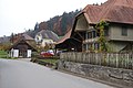
village street

Gasthaus Drei Confederation in Brittern
_156.JPG)
_155.JPG)
_267.JPG)
_264.JPG)
_231.JPG)
_247.JPG)
_228.JPG)
coat of arms
- Slanted left divided by black with a growing yellow lion, and by white with a black slanted right bar
Web links
- Peter Lätt: Aetingen. In: Historical Lexicon of Switzerland .
Biezwil |
Buchegg |
Lüsslingen-Nennigkofen |
Lüterkofen-Ichertswil |
Lüterswil-Gächliwil |
Measure |
Schnottwil |
Unterramsern
Former municipalities: Aetigkofen | Aetingen | Balm at trade fairs | Beavers | Brügglen | Brunnenthal | Gächliwil | Gossliwil | Hessigkofen | Ichertswil | Küttigkofen | Kyburg-Buchegg | Lüsslingen | Lueterkofen | Lüterswil | Mühledorf | Nennigkofen | Oberramsern | Tscheppach
Canton of Solothurn | Districts of the Canton of Solothurn | Municipalities of the Canton of Solothurn