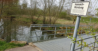
Nassach (Main)
| Nassach | ||
|
Where the Nassach flows into the Main |
||
| Data | ||
| Water code | DE : 24312 | |
| location |
Hatred Mountains
|
|
| River system | Rhine | |
| Drain over | Main → Rhine → North Sea | |
| source | near Nassach in the Hassberge mountains 50 ° 11 ′ 27 ″ N , 10 ° 27 ′ 41 ″ E |
|
| Source height | approx. 359 m above sea level NN | |
| muzzle | near Haßfurt in the Main Coordinates: 50 ° 1 ′ 50 ″ N , 10 ° 29 ′ 46 ″ E 50 ° 1 ′ 50 ″ N , 10 ° 29 ′ 46 ″ E |
|
| Mouth height | approx. 216 m above sea level NN | |
| Height difference | approx. 143 m | |
| Bottom slope | about 6 ‰ | |
| length | 23.9 km | |
| Catchment area | 157 km² | |
| Discharge at the Römershofen gauge (98.7% of the catchment area) A Eo : 138.64 km² Location: 8.5 km above the mouth |
NNQ MNQ 1980–2006 MQ 1980–2006 Mq 1980–2006 MHQ 1980–2006 HHQ (1995) |
94 l / s 185 l / s 884 l / s 6.4 l / (s km²) 18.5 m³ / s 30 m³ / s |
| Discharge A Eo : 140.49 km² at the mouth |
MQ 1980/2006 Mq 1980/2006 |
890 l / s 6.3 l / (s km²) |
| Small towns | Hassfurt | |
| Communities | Aidhausen , Hofheim in Lower Franconia , Koenigsberg in Bavaria | |
The Nassach is an almost twenty-four kilometer long right and northern tributary of the Main in Bavaria .
geography
course
The Nassach rises near the town of the same name Nassach in the Haßberge and flows into the Main at Haßfurt . It flows southeast to Lendershausen and then south.
In doing so, she crosses the towns
In a small semi-arch to the west it flows into the Main in Haßfurt on the right-hand side of the Main.
Tributaries
Inflows from the source to the mouth with length information
- Seegraben ( left ), 1.1 km
- Goldbach ( right ), 1.6 km
- Nesterbach ( right ). 1.3 km
- Höllschwärzgraben ( right ), 4.8 km
- Hörlebach ( right ), 2.7 km
- Rottensteiner Graben ( left ), 3.5 kn
- Nassach ( right ), 1.2 km
- Hinterbach ( right ), 1.2 km
- Lindiggraben ( right ), 1.7 km
- Sauergraben ( right ), 3.6 km
- Fischbach ( right ), 3.0 km
- Kippach ( right ), 3.2 km
- Aurach ( left ), 9.5 km, 24.94 km²
- Gollischbach ( right ), 2.5 km
- Prestenbach ( left ), 1.9 km
- Riedbach , ( right ), 15, km, 40.22 km²
- Hellinger Mühlbach ( left )
- Stebach ( left ), 2.0 km
- Langenbach ( right ), 1.9 km
- Liebesbächlein ( left ), 2.3 km
- Angersgraben ( left ), 1.6 km
- Desselbach ( right ), 2.0 km
Nassach river system
see list of rivers in the Nassach river system
fauna
In the Nassach, brown trout , brook loach , bream , minnow , gudgeon , hazel , pike , roach and tench , as well as occasional stone crabs in the backwaters, occur.
See also
Web links
- Gauge near Römershofen, HND Bavaria
Individual evidence
- ↑ a b Fischereiverband Unterfranken: Nassach ( page no longer available , search in web archives ) Info: The link was automatically marked as defective. Please check the link according to the instructions and then remove this notice.
- ^ Bavarian flood news service (as of September 7, 2013)
- ↑ Level data (MQ) from Römershofen , increased by the area discharge of the remaining catchment area (1.85 km²), area discharge of 6.1 l / s.km² determined from level data from Kemmern , Römershofen , Pettstadt , Vorra and Schweinfurt Neuer Hafen
- ↑ Self-measurement on the BayernAtlas
- ^ Name after Goldbachgasse
- ^ Name after Hinterbachweg and field name Hinterbach
