
List of architectural monuments in Seßlach
The monuments of the Upper Franconian town of Seßlach are compiled on this page . This table is a partial list of the list of architectural monuments in Bavaria . The basis is the Bavarian Monument List , which was first drawn up on the basis of the Bavarian Monument Protection Act of October 1, 1973 and has since been managed by the Bavarian State Office for Monument Preservation . The following information does not replace the legally binding information from the monument protection authority. This list reflects the update status from September 11, 2014 and contains 201 architectural monuments.

Ensembles
Ensemble Altstadt Seßlach

The second smallest town in Bavaria , located on the left bank of the Thuringian Rodach , is characterized by its complete cohesion. The town, which is still completely fortified with the exception of a short missing piece of the town wall, retains its medieval character on the field side. Inside, however, it is through the monumental and bourgeois buildings of the 17th and 18th centuries. Century more characterized as a baroque country town.
Who testified to 800 place northwest of the castle Geiersberg located, was given in 1335 by Gelnhauser pattern town charter and thus the right to fasten. The irregular oval Bering, which began at that time and which was renewed until the 18th century, is traversed by a large longitudinal axis (Luitpoldstrasse), which is joined in a T-shape by a cross street that forms the market square in front of the town hall and is located on the north side in front of the former Office building on Maximiliansplatz opens.
All gates of this Dreitoranlage remain: the tines or Coburg or Hattersdorfer Gate in the north, or Geiersberger- Ecker Dorfer gate to the South and Rothenberger or cen- or Schuldtor in the West.
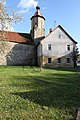
The late Gothic, Baroque town parish church stands on the church hill, a small elevation formerly in the north corner of the walling, later moved more into the city center by an extension north of the current Pfarrgasse. In addition to the sacred dominants of the parish church and the “urban” dominants of the city gates, the former prince-bishop monumental buildings determine the cityscape. These stately three-storey and massive buildings (Luitpoldstrasse 3, 7 and Maximiliansplatz 104) tower above the lower two-storey bourgeois half-timbered buildings. In the town center opposite the town hall, after a fire in 1905, the inner-city coherence of the main street was restored with a sensitive new building in the form of the Heimat style. File number: E-4-73-165-1.
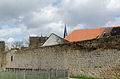
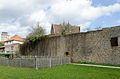
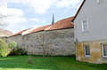
City fortifications Seßlach
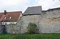
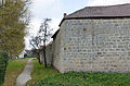
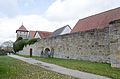
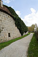
The late medieval wall ring has been preserved without battlements, except for a short section behind hall no. The wall consists of sandstone blocks. There are four wall towers and six wall stumps. There are loose rolling stones, so-called throwing stones, on the wall. The city wall was built from 1135 with the receipt of city and fortification rights and expanded in the 15th century. The fortifications were expanded in the late 16th and early 17th centuries. The former city moat is largely leveled, but kept clear. A moat has been preserved on the east and south sides. File number: D-4-73-165-3
The southern and western sections of the wall extend from the Geiersberger Tor to the Rothenberger Tor.
| location | object | description | File no. | image |
|---|---|---|---|---|
| Luitpoldstrasse 26; Geiersberger Tor; Near Heldenweg ( location ) |
Geiersberger gate tower | four-storey sandstone block building, 1343, 1551 heights, mansard roof from the 18th century; on the eastern wall of the passage there is a sandstone relief with a group of crosses, inscribed 1343 | D-4-73-165-4 |
 more pictures |
| Luitpoldstrasse 26; Geiersberger Tor; Near Heldenweg ( location ) |
Geiersberger gate tower | in front of it formerly a bridge | D-4-73-165-4 |
 more pictures |
| Luitpoldstrasse 26; Geiersberger Tor; Near Heldenweg ( location ) |
Geiersberger gate tower | on the eastern wall of the passage there is a sandstone relief with a group of crosses, inscribed 1343 | D-4-73-165-4 |
 more pictures |


City moat from Geiersdorfer Tor


angular wall tower stump


The wall section extends from Rothenberger Tor to Hattendorfer Tor.
| location | object | description | File no. | image |
|---|---|---|---|---|
| Flenderstrasse 88; Near Juliusweg ( location ) |
Rothenberger gate tower | four-storey sandstone square tower with tent roof, raised in 1610; in front of it massive parapet of the former baroque arch bridge | D-4-73-165-5 |
 more pictures |


Fourth defense tower at the lower Zwinger


The eastern section of the wall runs from Hattendorfer Tor to Geiersberger Tor. We still have the moat.
| location | object | description | File no. | image |
|---|---|---|---|---|
| Luitpoldstrasse 1 ( location ) |
Hattersdorfer gate tower | five-storey sandstone square tower, roof with pointed arch barrel, 15th to 16th centuries | D-4-73-165-6 |
 more pictures |

angular wall tower


round wall tower

round wall tower

polygonal wall tower


round wall tower stump

round wall tower stump


Architectural monuments according to districts
Sesslach
| location | object | description | File no. | image |
|---|---|---|---|---|
| At the Geiersberg; on the road to Witzmannsberg ( location ) |
Picture house | So-called Käppela, sandstone, housing attachment with two columns and arched niche on an antependium-like base, neo-Romanesque, late 19th century | D-4-73-165-81 |

|
| On Rothenberger Weg; on the road to Rothenberg ( location ) |
Wayside chapel | So-called Marienkäppela, sandstone block construction with a crooked hip roof, inside a niche with a sculpture, early 19th century | D-4-73-165-70 |

|
| On the sandy path; Krumbacher place; on the road to Witzmannsberg, near point 288.9 ( location ) |
Crucifix, | late 19th century | D-4-73-165-82 |

|
| On Watzendorfer Weg; on the road to Watzendorf , junction Neuseser Weg ( location ) |
Wayside shrine | Sandstone, 17th century, column renewed | D-4-73-165-78 |

|
| On Watzendorfer Weg; on Feldweg, 600 east of Geiersberg Castle ( location ) |
stele | so-called Xaverius Marter, sandstone with a relief of St. Francis Xavier, around 1750/60 | D-4-73-165-87 |

|
| Badstubengasse 58 ( location ) |
Two-storey half hipped roof house | Ground floor renewed, upper floor half-timbered, late 18th / early 19th century | D-4-73-165-8 |

|
| Bürgerwald; in the Bürgerwald on the way to Neuses an den Eichen ( location ) |
crucifix | so-called Red Cross, late 19th century | D-4-73-165-75 |

|
| Flenderstraße 37 ( location ) |
Golden Crown Inn | Two-storey corner building with gable, mansard and gable roof, built in the so-called Heimatstil after the town fire, marked 1906 | D-4-73-165-9 |

|
| Flenderstraße 39 ( me ) |
two-storey house | with gable and mansard roof, Heimatstil, 1906 | D-4-73-165-10 |

|
| Flenderstraße 40 ( me ) |
Three-storey residential and commercial building | with saddle roof and gable, half-timbered upper floor, Heimatstil, 1905 (marked 1906) by Conrad Bohrer | D-4-73-165-11 |

|
| Flenderstraße 42 ( location ) |
Half hipped roof house | plastered half-timbered upper floor, 18./19. century | D-4-73-165-12 |

|
| Flenderstraße 43 ( location ) |
Half hipped roof house | Half-hipped roof house, outside staircase with balustrade, 18th / 19th centuries century | D-4-73-165-13 |

|
| Flenderstraße 80 ( me ) |
Former hospital | today retirement home, elongated mansard roof building, 1763 (marked 1764) | D-4-73-165-14 |

|
| Flenderstraße 89 ( location ) |
Agricultural bourgeoisie | two-storey, gable-free, with a crooked hip, mainly around 1500, ground floor renovated in the 19th century, upper floor plastered half-timbering | D-4-73-165-15 |

|
| Flenderstraße 90 ( location ) |
Gabled house | two-storey, with half-hip, half-timbered upper storey, 16th century, front door marked with the year 1856. Wood investigations date the house to 1543. Its roof structure is 80 percent original. | D-4-73-165-16 |

|
| Flenderstraße 91 ( location ) |
Eaves side house | two-storey, with courtyard passage, half-timbered upper storey, mid-18th century | D-4-73-165-17 |

|
| Flenderstraße 94 ( location ) |
Gable roof house | two-storey, independent from the gable, upper storey half-timbered, mid-17th century, ground floor with drilled door and window frames changed in the mid-18th century | D-4-73-165-18 |

|
| Flenderstraße 95 ( location ) |
Red Ox Inn | two-storey corner house with half-hipped roof, half-timbered upper storey, 16th and 19th centuries | D-4-73-165-19 |

|
| Near Bahnhofstrasse; on the west wall of the Kreuzkapelle ( location ) |
crucifix | Sandstone, mid-18th century | D-4-73-165-68 |

|
| Near Bahnhofstrasse; in the cemetery ( location ) |
crucifix | Sandstone, marked 1890 | D-4-73-165-69 |

|
| Hofmannsplatz 68 ( location ) |
Gable roof house | two-storey, half-timbered, mid-18th century; with a baroque house figure under a lambrequin canopy | D-4-73-165-20 |

|
| Pits; Mühlau; Rodach; From Seßlach to Rothenberg ( location ) |
Inner Rodach Bridge | four-bay arch bridge, marked 1574 | D-4-73-165-63 |
 more pictures |
| Judengasse 76 ( location ) |
Gable roof house | two-storey, eaves, with courtyard passage, half-timbered, around 1690/1700 | D-4-73-165-21 |

|
| Juliusweg 127 ( location ) |
Town mill | Two-story hipped roof building, half-timbered upper floor, mainly 18th century, core from the 15th century, coat of arms stone marked with the year 1574 | D-4-73-165-23 |

|
| Juliusweg 127 ( location ) |
Former toe barn of the Würzburg Juliusspital | Elongated half-hipped roof building, coat of arms stone of the Würzburg Juliusspital marked 1701, it shows the ancestral coat of arms of the Echter von Mespelbrunn family . | D-4-73-165-22 |

|
| Bahnhofstrasse ( location ) |
Catholic Chapel of the Holy Cross | Hall construction with retracted choir, roof turret, 1705–1708 by Hanns Michael Schmitt; with equipment | D-4-73-165-2 |
 more pictures |
| Kirchplatz 10 ( location ) |
Gable roof house | narrow, two-story, plastered half-timbered upper floor, late 18th-early 19th century | D-4-73-165-30 |

|
| Kirchplatz 11 ( location ) |
Gable roof house | two-storey, half-timbered upper storey, probably first half of the 18th century | D-4-73-165-31 |

|
| Kirchplatz 12 ( location ) |
Former old school house | Gable roof house, massive ground floor with arched portal from the 17th century, half-timbered upper floor plastered 18th century | D-4-73-165-32 |
 more pictures |
| Konrad-Hartig-Platz 9 ( location ) |
Hip roof house | narrow, two-story, with floor bay, half-timbered upper floor, 18th century with an older core | D-4-73-165-29 |

|
| Church Square; Luitpoldstrasse 3 ( location ) |
War memorial | three stately stone pillars with a pedestal in front, 1922 | D-4-73-165-67 |

|
| Luitpoldstrasse 2 ( location ) |
Gable roof house | two-storey, eaves facing the street, plastered half-timbered upper floor, 17th / 19th century Century, portal marked 687 | D-4-73-165-24 |

|
| Luitpoldstrasse 3 ( location ) |
Former grain bulk floor of the Würzburg Juliusspital | today a schoolhouse, stately three-storey building, 1672–90, additional storey from 1727, more recent renovations | D-4-73-165-25 |
 more pictures |
| Luitpoldstrasse 6 ( location ) |
Two storey building | with a half-hipped mansard roof, plastered half-timbering, outside staircase, second half of the 18th century, in front of it paved path with gothic posts | D-4-73-165-26 |

|
| Luitpoldstrasse 7 ( location ) |
Former prince-bishop's official magazine and Schüttboden | Joseph Greissing built the stately, three-storey saddle roof building in 1714 as an official magazine on behalf of the Würzburg prince-bishop Johann Philipp von Greiffenclau zu Vollraths , whose coat of arms adorns the facade. A courtyard wall with a round arched gate surrounds the building, which after secularization served as a salt factory and later as a district court prison. | D-4-73-165-27 |
 more pictures |
| Luitpoldstrasse 8 ( location ) |
Two storey building | with mansard roof, street gable with half hip, courtyard passage, probably mid-18th century, slate with remains of painting | D-4-73-165-28 |

|
| Luitpoldstraße 9 ( location ) |
Catholic parish church of St. John the Baptist | late Gothic three-aisled staggered hall church with strongly recessed choir and four-storey tower, interior baroque, 15th – 19th centuries Century; with furnishings , Ölberg chapel with pent roof, probably second quarter of the 16th century | D-4-73-165-1 |
 more pictures |
| Luitpoldstraße 13 ( location ) |
Eaves side house | two-storey, with courtyard passage (marked 1614), mansard roof, 18th century | D-4-73-165-33 |

|
| Luitpoldstrasse 14 ( location ) |
Half hipped roof house | two-storey, eaves side, with courtyard passage (marked 1558/1604), half-timbered upper floor, open staircase with wrought iron railing, 16th to 18th century | D-4-73-165-34 |

|
| Luitpoldstrasse 15 ( location ) |
Half hipped roof house | two-storey, eaves side, outside staircase, third quarter of the 18th century | D-4-73-165-35 |

|
| Luitpoldstrasse 16 ( location ) |
Mansard roof house | two-storey, with gable, plastered half-timbered upper floor, courtyard fenced, outside staircase, second half of the 18th century, renovation around 1900/10 | D-4-73-165-36 |

|
| Luitpoldstraße 19 ( location ) |
Gable roof house | two-storey, eaves side, ground floor with arched gate entrance, 17th century, half-timbered upper storey marked 1700 | D-4-73-165-37 |

|
| Luitpoldstrasse 21 ( location ) |
Gable roof house | two-storey, eaves side, plastered half-timbered upper storey, open staircase, probably first half of the 18th century | D-4-73-165-39 |

|
| Luitpoldstraße 24 ( location ) |
Hip roof house | two-story, plastered half-timbered upper floor, outside staircase, second half of the 18th century with an older core | D-4-73-165-40 |

|
| Luitpoldstraße 26 ( location ) |
Gable roof house | two-storey, eaves side, with courtyard passage, half-timbered, probably first half of the 18th century | D-4-73-165-41 |

|
| Luitpoldstraße 27 ( location ) |
Gable roof house | two-storey, eaves side, with courtyard passage, half-timbered upper floor, marked 1779 | D-4-73-165-42 |

|
| Luitpoldstraße 28 ( location ) |
Sandstone slab | denotes 1614; walled in in the ground floor of the building Luitpoldstrasse 28, which was renovated in 1947, on the north side of the eaves | D-4-73-165-43 |

|
| Luitpoldstrasse 30 ( location ) |
Gable roof house | two-storey, eaves side, half-timbered upper floor, courtyard-side upper floor alcove, entrance marked 1686, renovation of the first floor in the late 19th century | D-4-73-165-44 |

|
| Luitpoldstrasse 31 ( location ) |
Agricultural bourgeoisie | two-storey, eaves side, with saddle roof, half-timbered, courtyard passage, early 17th century | D-4-73-165-45 |

|
| Luitpoldstraße 33 ( location ) |
Gable roof house | two-storey, eaves side, with half-timbered upper storey, marked 1556, renovated in the middle of the 19th century | D-4-73-165-46 |

|
| Luitpoldstrasse 35 ( location ) |
Corner house | picturesquely grouped, two-storey, Heimatstil, 1906 (marked 1907) by Conrad Bohrer | D-4-73-165-47 |

|
| Luitpoldstraße 36 ( location ) |
Neo-renaissance house | two-storey, with a gable roof and a dwelling, marked 1906 | D-4-73-165-48 |

|
| Marktplatz 96 ( location ) |
Hip roof house | two-storey, with courtyard passage, plastered half-timbering, richly architecturally structured portal, outside staircase, around 1700 | D-4-73-165-49 |

|
| Marktplatz 97 ( location ) |
Mansard roof house | two-storey, with half-hip gable, half-timbered upper floor, marked 1760 | D-4-73-165-50 |

|
| Marktplatz 98 ( location ) |
town hall | Half-hipped roof building with ridge turret, half-timbering, outside staircase with lion figure, in the core 16th century, 1796/1818 (local history museum). | D-4-73-165-51 |
 more pictures |
| Maximiliansplatz 99 ( location ) |
So-called High House | Stately three-storey saddle roof house in eaves position, half-timbered upper floors, roofing 1533, half-timbering, marked 1640, courtyard passage 17th century | D-4-73-165-52 |

|
| Maximiliansplatz 100 ( location ) |
Gabled house | two-storey, with a gable roof, half-timbering, early 18th century, ground floor changed | D-4-73-165-53 |

|
| Maximiliansplatz 101 ( location ) |
Gable roof house | two-storey, west gable with half hip, plastered half-timbering, probably 18th century, younger half-timbered bay | D-4-73-165-54 |

|
| Maximiliansplatz 102 ( location ) |
Hip roof house | two-story, with courtyard passage, half-timbered upper floor, 18th / 19th century century | D-4-73-165-55 |

|
| Maximiliansplatz 103 ( location ) |
Corner house | two-storey, with a gable roof, half-timbered upper storey, probably early 18th century, ground floor changed | D-4-73-165-56 |

|
| Maximiliansplatz 104 ( location ) |
Former prince-bishop's office | Stately three-storey saddle roof construction made of sandstone ashlar masonry, stepped gable, backwards polygonal stair tower, around 1620, changed in the 18th century, garden wall with gate entrance probably 17th century, barn | D-4-73-165-57 |
 more pictures |
| Pfarrgasse 106 ( location ) |
Hip roof house | two-storey, with courtyard passage, half-timbered upper storey, outside staircase, third quarter of the 18th century | D-4-73-165-58 |

|
| Pfarrgasse 110 ( location ) |
Half hipped roof house | two-story, half-hipped roof house, half-timbered, probably late 18th-early 19th century | D-4-73-165-59 |

|
| Pfarrgasse 111 ( location ) |
Rectory | Four-sided courtyard with a stately two-storey saddle roof residential building with courtyard entrance, half-timbered upper floor, open staircase, 16th century, mid-19th century; with equipment | D-4-73-165-60 |

|
| Pfarrgasse 112 ( location ) |
Gable roof house | two-storey in gable position, half-timbered, marked 1688 | D-4-73-165-61 |

|
| Pfarrgasse 113 ( location ) |
Half hipped roof house | two-storey, in eaves position, half-timbered, late 18th-early 19th century | D-4-73-165-62 |

|
| Rodach; on the Inner Rodach Bridge, northern parapet ( location ) |
Wayside shrine | Sandstone, pillar with a flat rectangular top, relief field with a crucifixion group, inscribed 1543 | D-4-73-165-71 |

|
| Near Flenderstraße; Near Heldenweg; on the southwest corner of the city wall ( location ) |
Wayside shrine | Sandstone, square pillar, top with arched niche, late 18th century | D-4-73-165-86 |

|
| County road CO 16; on the road to Witzmannsberg ( location ) |
Wayside shrine | Sandstone, on a pillar a rounded top with two flat niches, marked 1688 | D-4-73-165-84 |

|
| Near Geiersberg; at the Zehntplatz in front of the Geiersberger Tor in the Rückert-Gärtlein ( location ) |
Wayside shrine | So-called Zehntmarter, sandstone, table base with bas-relief, column with a two-sided relief top and iron cross, replica of the lost original, inscribed 1932 | D-4-73-165-77 |

|
| Rodach; on the Inner Rodach Bridge, southern parapet ( location ) |
St. John Nepomuk | Sandstone, marked 1714/1906 | D-4-73-165-72 |

|
| Church Square; at the parish church, north wall ( location ) |
crucifix | Stone cross, 19th century. | D-4-73-165-65 |

|
| Kirchgraben; on the way to the Rückäckerholz ( location ) |
Picture house (field altar) | so-called Käppela, sandstone, mid-18th century | D-4-73-165-85 |

|
| Industriestrasse ( location ) |
Plastered brick building with a gable roof | marked 1712, with high relief from the 14th century | D-4-73-165-73 |

|
| Near Zentweg; on the way to Rückäckerholz in the "Am Kirchgraben" area ( location ) |
Wayside shrine | Sandstone, base and pillar renewed, rectangular four-sided attachment with four reliefs, marked 1729 | D-4-73-165-80 |

|
| Near Coburger Strasse; Corner of Bahnhofstraße / Coburger Straße ( location ) |
Wayside shrine | Sandstone, four-sided, profiled base with flowers, on top of it square pillars with corner pillars, top with four flat niches that end like a three-pass, 1591 | D-4-73-165-66 |

|
| Poststrasse ( location ) |
Wayside shrine | So-called Barbara Marter, sandstone, bulbous square base, on it a sandstone column with a flat rectangular top with two reliefs, around 1760/70 | D-4-73-165-83 |

|
| Steinerweg; west of the road to Wiesen ( location ) |
crucifix | Sandstone, 19./20. century | D-4-73-165-74 |

|
| Near Zentweg; on the road to Witzmannsberg ( location ) |
crucifix | around 1910, marked with the year 1954 | D-4-73-165-79 |

|
| Frog pit; Industriestrasse; Stockau ( location ) |
Outer Rodach Bridge | three-bay arch bridge over the Froschgraben, sandstone, 1819 | D-4-73-165-64 |

|
| Near Grubensteiner Weg; on the road to Wiesen ( location ) |
crucifix | Sandstone, around 1900 | D-4-73-165-76 |

|
Aumühle
| location | object | description | File no. | image |
|---|---|---|---|---|
| Aumühle; on the dirt road west of the Rodach ( location ) |
Stone cross | Sandstone, late medieval | D-4-73-165-88 |

|
| Hattersdorf 32; west of the abandoned mill ( location ) |
crucifix | 19th century | D-4-73-165-89 |

|
Autenhausen
| location | object | description | File no. | image |
|---|---|---|---|---|
| Bergstrasse 17 ( location ) |
Catholic parish church of St. Sebastian | Hall building with retracted choir and single-tower facade, 1774; with equipment ; Cemetery wall with gate, marked 1777 | D-4-73-165-90 |
 more pictures |
| Bergstrasse 17 ( location ) |
crucifix | Sandstone, marked 1905. | D-4-73-165-97 |

|
| Bergstrasse 19 ( location ) |
Half hipped roof house | single storey, half-timbered, marked 1805 | D-4-73-165-91 |

|
| Brueckenstrasse; Corner of Brückenstrasse and Bergstrasse ( location ) |
statue | Immaculata on a curved square base, Rococo work, 1749 | D-4-73-165-99 |

|
| Near Erlenbach; Fork near the confluence of the Erlenbach in the Kreck next to the modern wayside chapel ( location ) |
crucifix | Wood, around 1900 | D-4-73-165-108 |

|
| County road CO 20; Near mountain road; Close to the town exit towards Gleismuthhausen ( location ) |
Wayside shrine | Sandstone column on a bulbous base, Corinthian capital, two-sided relief top and cross, inscribed 1706 and 1906 | D-4-73-165-103 |

|
| Near Lindenstrasse; Exit towards Gemünda at the junction to the Jewish cemetery ( location ) |
Wayside shrine | Sandstone, probably 19th century. | D-4-73-165-101 |

|
| Lindenstrasse 5 ( location ) |
Two-storey mansard half-hipped roof house | Half-timbered structure, western gable side slated, early 19th century | D-4-73-165-92 |

|
| Near Lindenstrasse, near No. 11 ( location ) |
Ruin of a mikveh | 18./19. century | D-4-73-165-199 | |
| Near Lindenstrasse; on the road to Gemünda at the junction to the Jewish cemetery ( location ) |
crucifix | Wooden cross under the linden trees, around 1900 | D-4-73-165-102 |

|
| Near Lindenstrasse; on the road to Gemünda, on the cellars ( location ) |
crucifix | Wooden cross on a stone base with inscription cartouche, inscribed 1770, cross renewed | D-4-73-165-100 |

|
| Near cross street; in the village between Brückenstrasse and Ringstrasse ( location ) |
crucifix | Wood, 1898 | D-4-73-165-107 |

|
| Near Rosengasse ( location ) |
Communal brewery | single-storey half-timbered house with half-hipped roof, early 19th century, later additions | D-4-73-165-200 |

|
| Thüringer Platz 1 ( location ) |
Two-storey half hipped roof house | Half-timbered structure over a high masonry base, arbor, 18th / 19th centuries century | D-4-73-165-93 |

|
| Thüringer Platz 5 ( location ) |
Former hunting lodge of the Langheim monastery | today vicarage, two-storey saddle roof building, half-timbered upper floor, 1581, in the 18th / 19th century Rebuilt in the 19th century; Courtyard wall with double gates | D-4-73-165-94 |
 more pictures |
| Thüringer Platz, in front of No. 5 ( location ) |
crucifix | Wood, around 1900 | D-4-73-165-106 |

|
| Thüringer Platz 13 ( location ) |
Parish hall | Half-hipped roof house, half-timbered upper floor on square columns, protruding, marked 1718, extended backwards in 1935 | D-4-73-165-95 |

|
| Üdelsdorf; southeast of the village ( location ) |
Jewish Cemetery | rectangular, step-shaped sandstone wall with two iron gates, 97 tombstones from the 19th to early 20th century | D-4-73-165-98 |
 more pictures |
| on the road to Gleismuthhausen ( ) |
crossroads | Crucifix, wood, around 1900; not re-qualified, not mapped in the Bavarian Monument Atlas | D-4-73-165-104 |
Bischwind
| location | object | description | File no. | image |
|---|---|---|---|---|
| Bischwind 9 ( location ) |
Single storey residential stable house | with half-hipped roof and porch, half-timbered upper floor, marked 1850 | D-4-73-165-201 |

|
| House number 16 ( location ) |
Two-storey saddle roof house | with ornamental framework and eaves, mid-19th century, added height in 1919 | D-4-73-165-202 |

|
| In Bischwind ( location ) |
Evangelical Lutheran Church | small hall building with ridge rider, probably second half of the 17th century, weather vane marked 1744, portal marked 1843; with equipment | D-4-73-165-109 |
 more pictures |
Dietersdorf
| location | object | description | File no. | image |
|---|---|---|---|---|
| Bahnhofsplatz 1 ( location ) |
Stone cross | Artificial stone, in memory of a car accident, 1911 | D-4-73-165-115 |

|
| Dietersdorfer Straße 5 ( location ) |
Catholic branch church St. Kilian | Hall building with mighty choir tower, 13. – 19. Century; with equipment | D-4-73-165-110 |
 more pictures |
| Dietersdorfer Straße 5 ( location ) |
Cemetery wall | Brocken masonry, medieval | D-4-73-165-112 |

|
| Dietersdorfer Straße 5 ( location ) |
Cemetery cross | Sandstone | D-4-73-165-112 |

|
| Near Schulstrasse; in front of the cemetery ( location ) |
Great crucifix | Sandstone, marked with the year 1892, behind it two memorial stones | D-4-73-165-113 |

|
| Near Zehentgasse ( location ) |
Former Würzburg tithe barn | stately saddle roof building, Wappenstein, marked with the year 1719 | D-4-73-165-111 |

|
| east in the village on the road towards Neundorf ( ) |
crucifix | Sandstone, 19th century; not re-qualified, not mapped in the Bavarian Monument Atlas | D-4-73-165-114 |
Gemünda in Upper Franconia
| location | object | description | File no. | image |
|---|---|---|---|---|
| At the red hill 7 ( location ) |
Two-storey half-timbered house | with gable roof, 18th century | D-4-73-165-119 |

|
| On red hill 10 ( location ) |
Stately farm property | Single-storey residential building with a half-hipped roof, partly modernly modified half-timbering marked with the year 1597, the portal marked with the year 1875 | D-4-73-165-120 |

|
| On red hill 10 ( location ) |
Stately farm property | Barn; two-storey outbuilding with a gable roof | D-4-73-165-120 |

|
| Heldburger Strasse 1 ( location ) |
Dreiseithof | Dreiseithof, main building, two-storey half-hipped roof house, half-timbered upper floor, marked 1805; Barn; Outbuildings; Courtyard wall with entrance and portal, sandstone, marked 1829. | D-4-73-165-121 |
 more pictures |
| Heldburger Strasse 3 ( location ) |
Two-storey half hipped roof house | Half-timbered, stable on the ground floor made of sandstone blocks, marked with the year 1822 | D-4-73-165-122 |

|
| Heldburger Strasse 4 ( location ) |
Heaped tailcoat roof house | Half-timbered upper floor, 18th century | D-4-73-165-123 |

|
| Heldburger Strasse 9 ( location ) |
Two-storey half hipped roof house | Fachwerk, 18./19. century | D-4-73-165-125 |

|
| Heldburger Strasse 10 ( location ) |
Half-timbered barn | early 19th century | D-4-73-165-126 |

|
| Heldburger Strasse 11 ( location ) |
Two-storey half hipped roof house | Slated half-timbered upper floor, two-story arbor, 19th century | D-4-73-165-127 |

|
| Heldburger Strasse 12 ( location ) |
The Red Ox Inn | Two-storey saddle roof building, half-timbered upper floor, renewed half-timbering, marked with the year 1594, portal marked with the year 1822 | D-4-73-165-128 |

|
| Heldburger Strasse 15 ( location ) |
Golden Lion Inn | Two-storey hipped roof house, half-timbered, laterally covered courtyard entrance, classicist doors, marked with the year 1789 | D-4-73-165-129 |

|
| Heldburger Strasse 19 ( location ) |
Two-storey saddle roof house | Half-timbered upper floor, half-timbered gable marked with the year 1683 | D-4-73-165-130 |

|
| Heldburger Strasse 21 ( location ) |
Two-storey saddle roof house | Laterally covered courtyard passage, plastered half-timbered upper floor, stable door marked with the year 1590 | D-4-73-165-131 |

|
| Heldburger Strasse 22 ( location ) |
Community house with forge | Two-storey saddle roof building, massive ground floor with porch supported by stone pillars, marked with the year 1587, half-timbered upper floor, marked with the year 1709, arbor | D-4-73-165-132 |

|
| Heldburger Strasse 26 ( location ) |
Two-storey saddle roof house | Half-timbered, plastered on the street side, western gable side slated, high arbor, late 17th / early 18th century | D-4-73-165-133 |

|
| Heldburgplatz 1; Heldburgplatz 2 ( location ) |
Churchyard wall | late medieval, arched, sandstone | D-4-73-165-118 |

|
| Heldburgplatz 2 ( location ) |
Evangelical Lutheran Parish Church of St. John | In the core a late medieval hall building with retracted choir and tower, marked with the year 1515, tower 1566-68, 1787 renovation of the nave; with equipment | D-4-73-165-117 |
 more pictures |
| Heldburgplatz 5 ( location ) |
Rectory | two-storey half hipped roof house, 1748; Bakehouse | D-4-73-165-124 |

|
| Heldburgplatz 5 ( location ) |
Half-timbered barn with a gable roof, early 19th century; | D-4-73-165-124 |

|
|
| Jägershof ( location ) |
Tithe barn | with gable roof, half-timbered, 18th century | D-4-73-165-203 | |
| Stegnersgasse 12 ( location ) |
Two-storey half hipped roof house | Half-timbered partially clad, two-storey arbor, modernly marked with the year 1793 | D-4-73-165-134 |

|
| Ummerstadter Straße 2 ( location ) |
Half-timbered barn | with a gable roof over the cellar entrance, marked with the year 1816 | D-4-73-165-135 |

|
Gleismuthhausen
| location | object | description | File no. | image |
|---|---|---|---|---|
| In Gleismuthhausen; western exit, on the road to Dürrenried ( location ) |
Stone cross | Sandstone, probably from the late Middle Ages | D-4-73-165-140 |

|
| In Gleismuthhausen; western exit, on the road to Dürrenried ( location ) |
crucifix | Wood, late 19th century | D-4-73-165-139 |

|
| Gleismuthhausen 8 1/2 ( location ) |
Filial church of St. Antonius Abbas | the core of the late medieval choir tower church, redesigned and renewed in 1766 and 1806; with equipment | D-4-73-165-136 |
 more pictures |
| Gleismuthhausen 8 1/2 ( location ) |
Churchyard wall | marked with the year 1570 | D-4-73-165-137 |

|
| Gleismuthhausen 8 1/2 ( location ) |
Churchyard cross | marked with the year 1899 | D-4-73-165-137 |

|
| In Gleismuthhausen; at the eastern exit of the town ( location ) |
stele | Sandstone with relief of St. Franz Xaver on a square base, around 1760/70 | D-4-73-165-141 |

|
| In Gleismuthhausen; Center at house number 37 ( location ) |
crucifix | Sandstone, around 1910 | D-4-73-165-138 |

|
| on the road to Autenhausen ( ) |
crucifix | Sandstone, marked with the year 1926; not re-qualified, not mapped in the Bavarian Monument Atlas | D-4-73-165-142 |

|
Hattersdorf
| location | object | description | File no. | image |
|---|---|---|---|---|
| In Hattersdorf ( location ) |
Stone trough | with an obelisk crowned by a ball, 1786/87 by Michael Trautmann (former in Tambach, figures lost) | D-4-73-165-147 |

|
| Hattersdorf 2 ( location ) |
Farmhouse | Two-storey half-timbered building with a passage and an attached stable part, around 1800 | D-4-73-165-198 |

|
| Hattersdorf 6 a ( location ) |
Former property of the Langheim monastery | stately sandstone block building with hipped roof, marked with the year 1630 | D-4-73-165-143 |

|
| Hattersdorf 10 ( location ) |
Tithe barn | plastered massive hipped roof building, marked with the year 1721 | D-4-73-165-146 |

|
| Hattersdorf 20 ( location ) |
Parish hall | two-storey half-timbered house, hipped roof with ridge turret, second half of the 18th century | D-4-73-165-145 |

|
| Hattersdorf 29 a ( location ) |
Former distillery and bakery | Two-storey sandstone block building with a gable roof, late classicist style, marked with the year 1852 | D-4-73-165-206 |

|
| Rodach; on the Rodachbrücke ( location ) |
Wayside shrine | Sandstone, four-sided top with a deep niche, marked with the year 1590, renovations from 1949 |

|
|
| State Road 2204; Local road junction from Dietersdorf-Seßlach ( location ) |
Wayside shrine | Sandstone, four-sided top with picture niches, marked with the year 1603 | D-4-73-165-148 |

|
| State Road 2204; near the junction of the local road from the Dietersdorf-Seßlach road ( location ) |
crucifix | Sandstone, marked with the year 1873 | D-4-73-165-150 |

|
Heilgersdorf
| location | object | description | File no. | image |
|---|---|---|---|---|
| Peasant leadership; Burgstall; Wiesener wood; in the forest about 115 m west-northwest point 343.6 (Röthberg) ( location ) |
Christian stone | massive boulder with names carved around 1860, sandstone | D-4-73-165-154 |

|
| Heilgersdorfer Hauptstraße 10 ( location ) |
Evangelical Lutheran Parish Church | Hall building with one-tower facade, 1753–58; with equipment | D-4-73-165-151 |
 more pictures |
| Rothenberger Strasse; Corner of Rothenberger / Heilgersdorfer Hauptstraße ( location ) |
Fountain | round, bellied stone trough, 18th century | D-4-73-165-153 |

|
| Schloßhof 3 ( location ) |
Heilgersdorf Castle | Two-storey three-wing complex with a mansard roof, 1716/17 (d), courtyard closed by loggia with baluster terrace, Lichtenstein-Veltheim marriage coat of arms above the main portal | D-4-73-165-152 |
 more pictures |
Krumbach
| location | object | description | File no. | image |
|---|---|---|---|---|
| In Krumbach, opposite house number 18 ( location ) |
Picture house | So-called Käppela, sandstone, on a pedestal top with a deep niche flanked by two pilasters, in it Our Lady with Christ Child, second half of the 19th century | D-4-73-165-158 |

|
| In Krumbach, next to house number 20a ( location ) |
Picture house | So-called Käppela, sandstone, on a base with a deep niche, 19th century | D-4-73-165-159 |

|
| In Krumbach, in front of house number 15 ( location ) |
Fountain | Sandstone, round bellied trough, 18th century | D-4-73-165-156 |

|
| In Krumbach, opposite house number 1 ( location ) |
Fountain | round bulbous trough, sandstone, 18th / 19th century century | D-4-73-165-155 |

|
| In Krumbach, in front of house number 21 ( location ) |
Wayside shrine | Sandstone, dimanted base, top with four relief fields, marked with the year 1721 | D-4-73-165-160 |

|
| Krumbach 16; on the way to Seßlach at point 342.8 ( location ) |
crucifix | Wood, around 1870 | D-4-73-165-161 |

|
| Krumbach 18 ( ) |
Farmhouse | two-storey hipped roof building with a gable facing the street, solid ground floor, upper floor exposed framework,
Crucifix on the gable end, sandstone, around 1890 |
D-4-73-165-157 |

|
| Strasser; on the Witzmannsberg-Seßlach road, at the junction to the village at point 316, 1 ( location ) |
Cross stone | medieval | D-4-73-165-162 |

|
| Tone scale; at point 356.0 ( location ) |
crucifix | Base and cross sandstone, corpus artificial stone, around 1870 | D-4-73-165-163 |

|
Lechenroth
| location | object | description | File no. | image |
|---|---|---|---|---|
| Lechenroth 15; Exit towards Muggenbach ( location ) |
Wayside shrine | Sandstone, square base, round shaft with spider and four-sided attachment, marked with the year 1800 | D-4-73-165-164 |

|
Merlach
| location | object | description | File no. | image |
|---|---|---|---|---|
| In Merlach ( location ) |
Community bake house | Sandstone block construction, mid-19th century | D-4-73-165-205 |

|
| Merlach 15 ( location ) |
Parish hall | Ground floor half hipped roof building, roof turret, late 18th century with modern renovations | D-4-73-165-165 |

|
| Merlach 15 ( location ) |
Communal brewery | Sandstone block building with a gable roof, mid-19th century | D-4-73-165-204 |

|
Muggenbach
| location | object | description | File no. | image |
|---|---|---|---|---|
| Lechenroth 14 ( location ) |
Former property of the Langheim monastery | in the core of the 16th century (marked with the year 1562), modified in the 19th century, massive two-storey house made of sandstone blocks with half-timbered gables and a gable roof; Farm building with stables, two-storey sandstone block construction with a gable roof; Outbuildings, single-storey sandstone blocks with a gable roof; Enclosing wall | D-4-73-165-166 |
 more pictures |
Oberelldorf
| location | object | description | File no. | image |
|---|---|---|---|---|
| Dorfstrasse 3 ( location ) |
Residential stable house | with hipped tailcoat roof, half-timbered upper floor, mid-19th century, entrance arbor renewed | D-4-73-165-169 |

|
| Dorfstrasse 6 ( location ) |
Fountain | Sandstone, bellied fountain trough, 18th century | D-4-73-165-173 |

|
| Dorfstrasse 13 ( location ) |
Two-storey stable house | with hipped roof, half-timbering, courtyard entrance with arbor, mid-19th century | D-4-73-165-170 |

|
| Dorfstrasse 14 ( location ) |
Single storey farmhouse | with crooked roof and arbor, partly half-timbered, first half of the 19th century | D-4-73-165-171 |

|
| Dorfstrasse 17 ( location ) |
Wayside shrine | Sandstone, square pillars, four-sided top with picture niches, marked with the year 1605 | D-4-73-165-175 |

|
| Friedhofsweg 1 ( location ) |
Catholic branch church | Choir tower church , in the core 14./15. Century, nave around 1710/20, neo-Gothic sacristy extension 1895; with equipment | D-4-73-165-167 |
 more pictures |
| Friedhofsweg 1; in front of the church ( location ) |
crucifix | Sandstone, marked with the year 1868 | D-4-73-165-174 |

|
| Friedhofsweg 1 ( location ) |
Churchyard | with an approximately oval churchyard wall, sandstone, probably from the late Middle Ages | D-4-73-165-168 |

|
| Gartenstrasse 2 ( location ) |
Farmhouse | Two-storey saddle roof building, ground floor with pilasters, half-timbered upper floor, marked 1893 | D-4-73-165-172 |

|
| Large mill range; on the forest path 350m south of point 348.9 ( location ) |
Tenth stone | Sandstone, marked with the year 1707 | D-4-73-165-180 |

|
| Army wood; east on the way to the fir wood ( location ) |
Picture house | Sandstone, table base, top with niche and iron cross, marked with the year 1873; with saint figure | D-4-73-165-179 |

|
| Small hallway; on Gartenstrasse ( location ) |
crucifix | Sandstone, around 1890 | D-4-73-165-176 |

|
| Krautfeld; east of the village ( location ) |
Wayside shrine | Sandstone, four-sided attachment with flat niches, marked 1605 | D-4-73-165-178 |

|
| Electoral fields; under the four linden trees, about 250 m northeast of the church ( location ) |
Wayside shrine | so-called Georgsmarter, sandstone, four-sided attachment with picture niches, inscribed 1605 | D-4-73-165-177 |

|
Rothenberg
| location | object | description | File no. | image |
|---|---|---|---|---|
| On the high street; on the dirt road to Sandmoos ( location ) |
Wayside shrine | Sandstone, column and rectangular top with two niches, marked with the year 1704 (rebuilt in 1960) | D-4-73-165-188 |

|
| In Rothenberg; opposite the church ( location ) |
crucifix | Sandstone, around 1900 | D-4-73-165-186 |

|
| Rothenberg 5 ( location ) |
Four-sided courtyard | two-storey stable house with gable roof, half-timbered upper floor, in the core sandstone block building from the 18th century; Outbuildings | D-4-73-165-181 |
 more pictures |
| Rothenberg 6 ( location ) |
Single storey residential stable house | with half-hipped roof, half-timbering over sandstone base, arbor, late 18th-early 19th century; Half-timbered barn, late 18th-early 19th century | D-4-73-165-182 |
 more pictures |
| Rothenberg 16 1/2; Rothenberg 17; on the southeast edge of the village ( Location ) |
crucifix | Sandstone, late 19th century | D-4-73-165-187 |

|
| Rothenberg 18 ( location ) |
Single-storey half-hipped roof house | Half-timbered, partly slated, cellar stall, arbor, mid-19th century | D-4-73-165-184 |

|
| Rothenberg 21 ( location ) |
Catholic branch church of St. Laurentius | Choir tower 15th and 17th centuries, nave around 1700; with equipment | D-4-73-165-185 |
 more pictures |
Geiersberg Castle
| location | object | description | File no. | image |
|---|---|---|---|---|
| At the Geiersberg; Near Geiersberg Castle; Sesslach 132; Seßlach 132a ( location ) |
Geiersberg Castle | Main building with hipped roof, 17th to 19th century, with a square stair tower, around 1600/20 | D-4-73-165-189 |

|
| At the Geiersberg; Near Geiersberg Castle; Sesslach 132; Seßlach 132a ( location ) |
Geiersberg Castle | Jägerhaus, hipped roof building from 1541 (marked) and former donjon, redesigned in a neo-Gothic style | D-4-73-165-189 |
|
| At the Geiersberg; Near Geiersberg Castle; Sesslach 132; Seßlach 132a ( location ) |
Geiersberg Castle | as a connection a curved late medieval shield wall; cistern | D-4-73-165-189 |
|
| At the Geiersberg; Near Geiersberg Castle; Sesslach 132; Seßlach 132a ( location ) |
Geiersberg Castle | northeast economic building, elongated two-storey hipped roof building, 1728/32 | D-4-73-165-189 | |
| At the Geiersberg; Near Geiersberg Castle; Sesslach 132; Seßlach 132a ( location ) |
Geiersberg Castle | East single-storey barn, half-hipped roof, first half of the 18th century | D-4-73-165-189 | |
| At the Geiersberg; approx. 300 m east of the castle near the road to Watzendorf ( location ) |
tower | square chapel tower with stepped gables, second half of the 19th century; with equipment | D-4-73-165-190 |

|
Unterelldorf
| location | object | description | File no. | image |
|---|---|---|---|---|
| Unterelldorf 3; Unterelldorf 4 ( location ) |
Gable roof house | one-storey, with half-timbered gable and roof turret, 18th / 19th century Century (weather vane marked 1730) | D-4-73-165-191 |

|
| Unterelldorf 14 ( location ) |
Two-storey stable house | Hipped tailcoat roof, half-timbering, arbor, mid-19th century | D-4-73-165-192 |

|
| Unterelldorf 31; at the exit towards Rothenberg ( location ) |
Wayside shrine | so-called Märtela, sandstone, on a square pillar top with flat niches, inscribed with the year 1803 | D-4-73-165-193 |

|
| Wag; on the street Unterellendorf - Hafenpreppach ( location ) |
Wayside shrine | Sandstone on a square pillar top with two flat niches, around 1800 | D-4-73-165-194 |

|
| Goat mounds; at the exit towards Oberelldorf ( location ) |
Wayside shrine | Sandstone, on a pillar flat top with two picture niches, probably 17th century | D-4-73-165-195 |

|
grasslands
| location | object | description | File no. | image |
|---|---|---|---|---|
| Christensteinsleite; on the way to Heilgersdorf, 200 m west of Schloss Wiesen ( location ) |
Cross stone | inscribed 1643 | D-4-73-165-197 |

|
| Schloss Wiesen 1 ( location ) |
lock | stately three-storey gable roof building with a round corner tower, half-timbered gable, 16th century | D-4-73-165-196 |

|
| Schloss Wiesen 1 ( location ) |
lock | Ground floor farm building with arched portals, probably 16th century | D-4-73-165-196 |
Former architectural monuments according to districts
This section lists objects that were previously entered in the list of monuments.
Sesslach
| location | object | description | File no. | image |
|---|---|---|---|---|
| Luitpoldstrasse 20 ( location ) |
Gable roof house | two-storey, eaves side, with basket arched passage gate in sandstone frame, half-timbered upper storey, around 1700 | D-4-73-165-38 |

|
See also
Remarks
- ↑ This list may not correspond to the current status of the official list of monuments. The latter can be viewed on the Internet as a PDF using the link given under web links and is also mapped in the Bavarian Monument Atlas . Even these representations, although they are updated daily by the Bavarian State Office for Monument Preservation , do not always and everywhere reflect the current status. Therefore, the presence or absence of an object in this list or in the Bavarian Monument Atlas does not guarantee that it is currently a registered monument or not. The Bavarian List of Monuments is also an information directory. The property of a monument - and thus the legal protection - is defined in Art. 1 of the Bavarian Monument Protection Act (BayDSchG) and does not depend on the mapping in the Monument Atlas and the entry in the Bavarian Monument List. Objects that are not listed in the Bavarian Monument List can also be monuments if they meet the criteria according to Art. 1 BayDSchG. Early involvement of the Bavarian State Office for Monument Preservation according to Art. 6 BayDSchG is therefore necessary in all projects.
literature
- Denis André Chevalley: Upper Franconia . Ed .: Michael Petzet , Bavarian State Office for the Preservation of Monuments (= Monuments in Bavaria . Volume IV ). Oldenbourg, Munich 1986, ISBN 3-486-52395-3 .
Web links
- Bavarian Monument Atlas (cartographic representation of the Bavarian architectural and ground monuments by the BLfD , requires JavaScript)
- List of monuments for Seßlach (PDF) at the Bavarian State Office for Monument Preservation
Individual evidence
- ^ Coburger Tageblatt, February 24, 2016
