
List of architectural monuments in Bad Rodach
The monuments of the Upper Franconian community Bad Rodach are compiled on this page . This table is a partial list of the list of architectural monuments in Bavaria . The basis is the Bavarian Monument List , which was first drawn up on the basis of the Bavarian Monument Protection Act of October 1, 1973 and has since been managed by the Bavarian State Office for Monument Preservation . The following information does not replace the legally binding information from the monument protection authority. This list reflects the update status of October 29, 2014 and contains 106 monuments.

ensemble
Old town Bad Rodach with southern and western suburbs

The ensemble includes the old town and the southern and western suburbs of the city, which recently began to develop into a thermal bath. In the 11th century, a small village settlement was located at an originally royal court, first mentioned in 899. To the south of the settlement and south of the Coburg - Hildburghausen road that passed here, an urban settlement was planned around 1300. Rodach received in 1362 from the hen Bergern the city charter and was at the end of the 14th century umwehrt. After it had been upgraded to a state fortress of Electoral Saxony in 1531 , a new fortification took place. This bering with walls, towers and trenches surrounds the northern half of the city for the most part still today. Of the city gates, only the copper tower is preserved, which was built to protect the defunct Hildburghausen gate. The former fortification ring is also clearly visible in the structure of the south-eastern city quarter, even if only a short section of the wall has been preserved here. The northern half of the city preserves an ancient street course. This is also where the most important monumental buildings rise: in the east corner the baroque parish church, 1755–58 by JJ Deumler and in the west corner the former hunting lodge built in 1748/49 for Duke Franz Josias according to plans by Johann David Steingruber . The southern half of the old town opens up to the elongated market square that tapers slightly to the south. Its plaza walls were largely destroyed in city fires in 1825 and 1862, but the town hall and the Markt 4, 5 and 21 properties are older buildings. When the west side of the market was rebuilt, the city wall behind it was removed and reused for the new buildings. The bourgeois development of the old town often corresponds to the type of urban closed farm with half-timbered buildings from the 19th century and is often classicist - Biedermeier in the eaves-side residential buildings . It continues in the suburbs: in Heldburger Strasse, which extends the market square to the south beyond the former Bering, and in Hildburghäuser Strasse as far as the cemetery church from 1742/49. (File number: E-4-73-158-1)
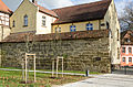
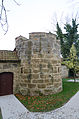
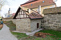
City fortifications
The city fortifications from the 14th century consist of walls, towers and moats. Most of the wall belt around the northern half of the city has been preserved. In the south, pieces of the wall on the Old Wall Trail back from Wallgasse 1 have been preserved.
The preserved northern wall ring runs along Rückertstraße from Schloßplatz 2 to Schulgasse 3.

Wall move on Schloßplatz
Wall move on Schloßplatz
Wall move at Schloßplatz 4

Tower at Schloßplatz 4

Wall move at Schloßplatz 6

Wall move at Schloßplatz 6
Tower stump at Schloßplatz 6
Wall move at Schloßplatz 6
City wall, tower, old school and St. Johannis parish church at Kirchgasse 5

Powder tower at Kirchgasse 3


| location | object | description | File no. | image |
|---|---|---|---|---|
| Hildburghäuser Strasse ( location ) |
Copper tower | The copper tower is a late medieval city wall tower with a half-timbered upper floor as well as a hipped roof and ridge turrets. | D-4-73-158-9 |

|
| Wallgasse 1 ( location ) |
city wall | Backwards, 14th century | D-4-73-158-1 |
.JPG)
|
Architectural monuments according to districts
Bad Rodach
| location | object | description | File no. | image |
|---|---|---|---|---|
| Noble houses field; Stream meadows; Eichelberg; Frauenberg; Behind the mill; Hörlebach; Little High Rain; Long fields; Hole; Mühlweg; Upper Melm; Peterswiesen; Rodach; Peace gardens; Clearing meadows; Sandberg; Sheep's rest; Club; St 2205; From Adelhausen to Lempertshausen; From Massenhausen to Lempertshausen; Wüstenseewiesen ( location ) |
Landmarks | Numerous boundary stones for the Duchy of Saxony-Coburg and Saxony-Meiningen, consecutive numbering (212 e.g. on the road to Adelhausen / Hildburghausen), mid-19th century; on the border with Thuringia | D-4-73-158-35 |

|
| Alexandrinenstraße 3 ( location ) |
Corner house | The two-storey corner house at the intersection of Alexandrinenstrasse and Grabenweg was built in late historic style around 1905. It is characterized by a bay tower, branch and step gables and half-timbered buildings on the upper floor | D-4-73-158-92 |
.JPG)
|
| Bahnstrasse 1 ( location ) |
Sanctimeter house | Four-sided courtyard, two-storey half-timbered house with saddle roof and high arbor, partly slated; Half-timbered barn with saddle roof, core 18th century | D-4-73-158-2 |
 more pictures |
| On the road to Adelhausen in front of the former border ( ) |
Remains of a stone bench and milestone | 19th century; not re-qualified | D-4-73-158-36 | |
| Coburger Strasse 40 ( location ) |
Former toy factory | Stately two-storey half-timbered building with a gable roof and dwarf house, slate with painting, 1834 | D-4-73-158-3 |
.JPG)
|
| Gartenstrasse 24 ( location ) |
Carved heraldic shield of the toy factory | Probably late 19th century | D-4-73-158-4 |

|
| Gerbergasse 2 ( location ) |
Agricultural bourgeoisie | Two-storey half-timbered house with gable roof and car entrance, 18th / 19th centuries century | D-4-73-158-5 |

|
| Gerbergasse 20, 22a ( location ) |
Gable roof house | Stately, two-storey, on the basement, arbor backwards, in the core 17th / 18th. Century, major changes | D-4-73-158-6 |

|
| Heldburger Strasse 14 ( location ) |
So-called Fridolin House | Picturesque two-story half-timbered building with towers and a dwelling, massive ground floor, grouped around the inner courtyard, 1914 with an older core | D-4-73-158-7 |
.JPG) more pictures |
| Heldburger Strasse 47 ( location ) |
Station building | Two-storey slated half-timbered building with half-hipped roof, dwarf house projection, 1892; the goods hall, a half-timbered building from 1913, has 135 square meters of floor space. | D-4-73-158-116 |

|
| Herrengasse 6 ( location ) |
Former rectory | Two-storey mansard roof building, outside staircase, around 1800 | D-4-73-158-8 |

|
| Hildburghäuser Strasse 11 ( location ) |
Half hipped roof house | Two-storey, half-timbered upper storey, 18th century | D-4-73-158-10 |

|
| Hildburghäuser Strasse 13 ( location ) |
Half-timbered house | Two-storey with a gable roof, 19th century | D-4-73-158-11 |

|
| Hildburghäuser Strasse 14 ( location ) |
Half-timbered house | Two-storey, with a gable roof, courtyard entrance, 18th century | D-4-73-158-12 |

|
| Hildburghäuser Strasse 17 ( location ) |
Evangelical Lutheran Cemetery Church of St. Salvator | Hall building with ridge turret, 1742–49; with equipment | D-4-73-158-13 |
 more pictures |
| Hildburghäuser Strasse 17 ( location ) |
graveyard | With cemetery wall and built-in spoilers ; War memorial, 1922 by the Heldburg sculptor Leybold; Funerary monuments | D-4-73-158-14 |
 more pictures |
| Hirschmüllersweg 1 ( location ) |
Deer mill | Half-hipped roof building, half-timbered, first half of the 19th century; Farm buildings, the barn 18th century | D-4-73-158-33 |

|
| Near Hirschmüllersweg; in front of the Hirschmühle ( location ) |
Hunting landmark | Designated "1706" | D-4-73-158-34 |
.JPG)
|
| Kirchgasse 3 ( location ) |
Former Latin school in Rodach | Two-storey half-timbered building with gable roof, plastered ground floor, 17th / 18th centuries century | D-4-73-158-16 |
 more pictures |
| Kirchgasse 5 ( location ) |
Evangelical Lutheran Parish Church of St. Johannis | Hall building 1755–58 based on a design by Johann Jakob Deumler with a 15th century tower; with equipment | D-4-73-158-15 |
 more pictures |
| Kirchgasse 6 ( location ) |
House Steitzer | Agricultural bourgeois house, two-storey saddle roof building made of sandstone blocks with a dwarf house, rich Romanizing-Gothic decor, inscribed "1840" | D-4-73-158-17 |
 more pictures |
| Kirchgasse 10 ( location ) |
Half-timbered house and half-timbered barn | Two-storey, plastered half-timbered house with a gable roof, 18th century; back yard with half-timbered barn with gable roof | D-4-73-158-18 |
 more pictures |
| Lempertshäuser Straße 13 ( location ) |
Catholic parish church of St. Marien | The church was built according to a design by the architect Josef Rauschen from 1953 and was consecrated in 1957 . It has a trapezoidal plan with an altar facing west. The west and north facades are characterized by large, colorfully glazed windows. A campanile stands south of the nave | D-4-73-158-117 |
 more pictures |
| Market ( location ) |
Market fountain | Polygonal basin with well column, 1891 (marked "1873") | D-4-73-158-25 |
 more pictures |
| Market 1 ( location ) |
town hall | Two-storey saddle roof building with a gable facade and turret , essentially a half-timbered building from 1660, rebuilt in a neo-renaissance style in 1903 | D-4-73-158-20 |
 more pictures |
| Market 3 ( location ) |
pharmacy | Two-storey eaves side house with rich neo-Gothic decor on the ground floor, mid-19th century | D-4-73-158-21 |
 more pictures |
| Market 4 ( location ) |
Erffenhaus, formerly used as a post office | Two-storey hipped roof building. It bears the year "1690" as a name and was rebuilt in the 19th century. The building has grooved corner pilasters and a rusticated portal on the ground floor. The half-timbered upper floor is clad. | D-4-73-158-22 |
 more pictures |
| Market 5 ( location ) |
The Golden Lion Inn | The two-storey half-timbered house from the 17th / 18th Century stands on the market in a corner to Hildburghäuser Strasse. The cellar was probably built before the Thirty Years War . The building has a gable roof and a stately gable facing Hildburghäuser Strasse. Until 1986 it housed the Gasthof Zum golden Löwen. It has been empty since then. The city acquired the property in 2014. | D-4-73-158-23 |
 more pictures |
| Market 21 ( location ) |
Eaves side house | Two-storey, with a gate, the rest of the abandoned Hotel Schmerl, inscribed "1633" | D-4-73-158-24 |
 more pictures |
| Schloßplatz ( location ) |
Memorial to Superintendent Christian Hohnbaum | Relief portrait on a boulder, 1907 by E. Wegner | D-4-73-158-30 |
 more pictures |
| Schloßplatz 1 / 1a ( location ) |
Former district court | With prison, two-storey neo-renaissance building with saddle roof and stepped gable, around 1900 | D-4-73-158-27 |
 more pictures |
| Schloßplatz 4 ( location ) |
Rückert School | Two-storey neo-renaissance building with a gable roof and ornamental gable, was added to the city wall tower in 1905 | D-4-73-158-28 |
 more pictures |
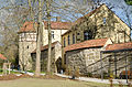
| Schloßplatz 5 ( location ) |
Former ducal hunting lodge | Two-storey hipped roof building with a three-storey central projection, 1748–49 by Johann David Steingruber ; with equipment | D-4-73-158-29 |
 more pictures |
| Schulgasse 3 ( location ) |
Old school | Two-storey half-timbered building with a saddle roof, 1696, sitting on the city wall: Powder tower, 16th century | D-4-73-158-31 |
 more pictures |
| Schulgasse 4 ( location ) |
Half-timbered house | One storey, with a gable roof, second half of the 17th century, inscribed "1841" | D-4-73-158-106 |
 more pictures |
Breitenau
| location | object | description | File no. | image |
|---|---|---|---|---|
| Bergstrasse 2 ( location ) |
Farmhouse | Half-timbered, two-storey Borlaube, probably 18th century | D-4-73-158-37 |

|
| Bergstrasse 5 ( location ) |
Evangelical Lutheran Church of Our Lady | Hall building with choir tower, medieval core, in the 17th – 19th centuries Century; with equipment | D-4-73-158-38 |
 more pictures |
| Dorfstrasse 5 ( location ) |
Farmhouse | Half-timbered, two-storey Borlaube, 18th century | D-4-73-158-39 |

|
| Dorfstrasse 10 ( location ) |
Farmhouse | Upper floor slated in a German template, hip hip, first half of the 19th century | D-4-73-158-40 |

|
| Dorfstrasse 11 ( location ) |
Farmhouse | Slipped, inscribed "1874" | D-4-73-158-41 |

|
Elsa
| location | object | description | File no. | image |
|---|---|---|---|---|
| At the Wied 4 ( location ) |
Residential stable house | Two-storey, historicist, with a gable roof and dwelling houses, around 1910 | D-4-73-158-113 |

|
| Pfarrsteig 2 ( location ) |
For this pigsty | Sandstone blocks and half-timbered, boarded up | D-4-73-158-115 |

|
| Pfarrsteig 4; Pfarrsteig 2 ( location ) |
Parish church | 15th century choir tower, neo-Gothic church house, inscribed "1866"; with equipment ; Cemetery walling, gate marked "1754" | D-4-73-158-43 |
 more pictures |
| Pfarrsteig 6, by the church ( location ) |
Evangelical Lutheran rectory | Hipped roof, gate post and courtyard gate, 18th century | D-4-73-158-44 |

|
| Riedweg 6 ( location ) |
Residential stable house | Two-storey, slated, with a gable roof, fretwork decorations in the gable area, 1905, in the core probably early 19th century | D-4-73-158-114 |

|
| Riedweg 7 ( location ) |
Residential stable house | Two-storey, slated, with a gable roof, inscribed "1883" | D-4-73-158-110 |

|
| Riedweg 11 ( location ) |
Residential stable house | Two-storey, slated, with a gable roof, inscribed "1881", in the core 18th century | D-4-73-158-109 |

|
| Walburer Weg 6 ( location ) |
Residential stable house | Two-storey, slated, with a gable roof, two-storey Borlaube, remains of classical slate painting, inscribed "1817" | D-4-73-158-111 |

|
| Walburer Weg 10 ( location ) |
Residential stable house | Slate, with tailcoat roof, arcade, end of the 19th century, in the core 1721 | D-4-73-158-112 |

|
| Zur Wart, on the left of the road to Rodach, 100 m east of the boundary at Luther-Linde ( location ) |
Stone mark | Sandstone | D-4-73-158-45 |
Gauerstadt
| location | object | description | File no. | image |
|---|---|---|---|---|
| Billmuthäuser Straße 3 ( location ) |
Single storey half-timbered house | Gable with ornamental framework, 1702 | D-4-73-158-98 |

|
| Billmuthäuser Straße 6 ( location ) |
Core of the residential and commercial building | Two-storey saddle roof construction; barrel vaulted cellar, probably remnants of a late medieval alley system; Corner turret; Shop entrance and window around 1900 | D-4-73-158-46 |
.jpg)
|
| Billmuthhäuser Straße 8 ( location ) |
Evangelical Parish Church of St. Mary | Medieval choir tower, nave 1797–1800; with equipment | D-4-73-158-47 |
.jpg) more pictures |
| Billmuthhäuser Straße 8 ( location ) |
War memorial | For 1866, 1870/71 and 1914–18, sandstone; in front of the church | D-4-73-158-51 |

|
| Billmuthäuser Straße 9 ( location ) |
Half-timbered house | Two-storey, plastered, gable with ornamental framework, inscribed "1669" | D-4-73-158-99 |

|
| Billmuthäuser Straße 10 ( location ) |
Rectory | Two-storey half-timbered house with gable roof, partly slated, 17th / 18th centuries Century; Stable wing with wooden shed; Half-timbered barn 19th century;
Sandstone ashlar wall marked "1744" |
D-4-73-158-48 |
.jpg)
|
| Billmuthäuser Straße 13 ( location ) |
Former inn | Two-storey saddle roof building, half-timbered, around 1700 | D-4-73-158-100 |

|
| Billmuthäuser Straße 15 ( location ) |
Half-timbered house | 18th century | D-4-73-158-49 |

|
| Domain Street 2 ( location ) |
Residential stable house with dwelling houses | Ornamental framework, around 1900 | D-4-73-158-101 |

|
| Rodacher Strasse ( location ) |
Stone bridge | Einjochig, over the Rodach, Sandstein, 18./19. Century; east of the place | D-4-73-158-52 |

|
| Rodacher Strasse 2 ( location ) |
House with a cross roof | Brick and sandstone, knee-high with ornamental framework, fretwork decor, around 1900 | D-4-73-158-102 |

|
| Rodacher Strasse 10 ( location ) |
Dreiseithof | Half-timbered house, inscribed "1799"; Outbuilding half-timbered with sliding shutters | D-4-73-158-50 |

|
| Rodacher Strasse 17a ( location ) |
Former manor house | Two-storey half-timbered building with a mansard hipped roof, 1789 | D-4-73-158-103 |

|
| Schulstrasse 1 ( location ) |
Former school house | Facing bricks and framework, partially slated, marked "1877" | D-4-73-158-104 |

|
| Stumpf, at the west exit, embankment of the road to Gauerstadt, 900 m west-southwest point 307.4 ( location ) |
So-called Gauerstadter Cross | Stone cross | D-4-73-158-42 |

|
| At the Gauerstadt / Breitenau land border ( ) |
Atonement Cross | Late medieval; | D-4-73-158-105 |
Ridge town
| location | object | description | File no. | image |
|---|---|---|---|---|
| Ahlstadter Weg 10 ( location ) |
Treasure | The farmhouse was the home of a property that is named after the liege Johann Conrad Häublein zu Eisfeld. The half-timbered building dates from the first half of the 19th century and was extended in 1874. In 1912 the arbor was added. | D-4-73-158-54 |

|
| Am Kirchsteig 3 ( location ) |
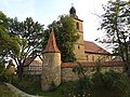
Evangelical Lutheran branch church of St. Paul | Hall building with triangular closure, hipped roof with ridge turret, around 1686, alterations in 1755 and 1864; with equipment | D-4-73-158-53 |
 more pictures |
Hero third
| location | object | description | File no. | image |
|---|---|---|---|---|
| Am Schafberg 3-4 ( location ) |
Barn and stable construction | Handsome, half-hip, 19th century; belonging to an abandoned farmhouse across the street, in an effective position above the village | D-4-73-158-63 |

|
| Grabengasse 2 ( location ) |
Dreiseithof | Two-storey house, half-timbered, arbor, 19th century | D-4-73-158-60 |

|
| Hauptstrasse 1 ( location ) |
Farmhouse | Ground floor with hipped mansard roof, arbor around 1800 | D-4-73-158-67 |

|
| Hauptstrasse 12 ( location ) |
Farmhouse | Ground floor, half-hipped roof around 1800 | D-4-73-158-61 |

|
| Kleine Gasse 5 ( location ) |
Farmhouse | Ground floor, hipped mansard roof, slate in German template with traces of old painting, inscribed "1787" | D-4-73-158-59 |

|
| Lutherweg 10 ( location ) |
Dreiseithof | Slated house with a ground floor arbor, first half of the 19th century | D-4-73-158-66 |

|
| Reithweg 2 ( location ) |
Two-storey farmhouse | Half-timbered, partly slated, 18th century, heightened in 1919 | D-4-73-158-108 |

|
| Schloßberg 3 ( location ) |
lock | Two-storey two-wing complex, 19th and early 20th centuries (mainly 16th / 17th centuries); Wappenstein inscribed "1823" and "1934"; neo-Romanesque barn, inscribed "1838" | D-4-73-158-58 |
.JPG) more pictures |
| Schloßberg 5 ( location ) |
Rectory | Half-timbered plastered, 17th / 18th centuries Century, core probably 16th century | D-4-73-158-56 |

|
| Schlossberg 7; Near Am Schafberg; Schloßberg 9 ( location ) |
Evangelical Lutheran Church of St. Nicholas | Choir tower in the core around 1500, tail dome 18th century, church house neo-Romanesque, "1847" (inscribed); with equipment ; Cemetery wall | D-4-73-158-55 |
 more pictures |
| Schloßberg 9 ( location ) |
Residential building | Ground floor with a dwelling, marked "1855" | D-4-73-158-57 |

|
| To Mühle 19, 300 m from the outskirts at Mühlbach ( location ) |
Former mill and sawmill | Two-storey house, early 19th century, side wing older | D-4-73-158-68 |
.JPG)
|
| Zur Schwaige 4 ( location ) |
Farmhouse | Half-timbered construction, slate with traces of ornamental painting, ground floor arbor connects with stable part, 18./19. century | D-4-73-158-64 |

|
| To Schwaige 5 ( location ) |
Community chancellery | Two-storey slated gable roof building with roof turret, inscribed "1871" (there former Lower Castle). | D-4-73-158-65 |
 more pictures |
Moravia home
| location | object | description | File no. | image |
|---|---|---|---|---|
| Near Moravia, opposite the school ( location ) |
War memorial for 1914–18 and 1949–45 | D-4-73-158-69 |

|
Niederndorf
| location | object | description | File no. | image |
|---|---|---|---|---|
| Colberger Strasse 3 ( location ) |
Farmhouse | Ground floor, half-timbered, 19th century | D-4-73-158-70 |

|
Oettingshausen
| location | object | description | File no. | image |
|---|---|---|---|---|
| Am Harrasgraben 2 ( location ) |
Farmhouse | With German stencils and remains of painting, early 19th century | D-4-73-158-75 |

|
| Am Harrasgraben 6 ( location ) |
Farmhouse | Ground floor, hipped mansard roof, around 1800 | D-4-73-158-74 |

|
| Am Harrasgraben 17 ( location ) |
Former Schunk inn | Two-storey classifying farmhouse, slate German stencil with traces of painting, inscribed "1820" | D-4-73-158-73 |

|
| Am Kirchrangen 6 ( location ) |
Evangelical Lutheran Church of Kilians | New building in 1969 based on plans by Herbert Fischer, Schwürbitz; 18th century organ | D-4-73-158-71 |
 more pictures |
| Am Kirchrangen 8 ( location ) |
Evangelical Lutheran rectory, former Evangelical Lutheran rectory | Upper floor slated; Garden portal marked "1739" | D-4-73-158-72 |

|
Rossfeld
| location | object | description | File no. | image |
|---|---|---|---|---|
| Obere Mühlgasse 8 ( location ) |
Dreiseithof | Two-storey residential building with a gable roof and mid-tier, half-timbered, inscribed "1813", slateing of the residential building 1892; Half-timbered barn with a gable roof | D-4-73-158-79 |

|
| Rudelsdorfer Straße 14 ( location ) |
Farmhouse | Two-storey farmhouse with saddle roofs, upper floor half-timbered, partially slated with painting, Heimatstil, inscribed "1910" | D-4-73-158-85 |

|
| Lake, at the dike breakthrough of former fishing water in the brook meadow base ( location ) |
Sandstone walkway | Inscribed "1720" | D-4-73-158-96 |

|
| Streudorfer Straße 2, east of the village on the Rodach ( location ) |
Brewery | Single-storey half-timbered house with crooked hip, 18th century | D-4-73-158-78 |

|
| Streufdorfer Straße 10 ( location ) |
Rectory | Two-storey mansard roof building with half-timbered upper storey, around 1800 | D-4-73-158-77 |

|
| Streufdorfer Straße 11 ( location ) |
Mansard roof house | Half-timbered structure with slate, probably from the 18th century | D-4-73-158-80 |
.JPG)
|
| Streufdorfer Straße 14 ( location ) |
Evangelical Lutheran Parish Church of St. Margareta | Late Gothic choir tower church , remodeling 17th and 18th centuries; with equipment ; Cemetery with damaged 18th century gravestones | D-4-73-158-76 |
 more pictures |
Rudelsdorf
| location | object | description | File no. | image |
|---|---|---|---|---|
| On the sand ( location ) |
Basement portal | Sandstone, based on a Greek treasure house, 19th century | D-4-73-158-89 |

|
| Near Rudelsdorf ( location ) |
lock | Remnants of the wall and vaulted cellar of an abandoned castle | D-4-73-158-86 |

|
| Rudelsdorf 5 ( location ) |
Residential stable house | One storey, with a gable roof, timber frame, inscribed "1755" and "1883" | D-4-73-158-97 |

|
| Rudelsdorf 10 ( location ) |
Parish hall | Two-storey half-timbered building with a gable roof and gable turret, 1742 | D-4-73-158-87 |

|
Schweighof
| location | object | description | File no. | image |
|---|---|---|---|---|
| Schweighof ( location ) |
State domain building Schweighof | Residential house, two-storey bare brick building with half-timbered knee floor, around 1890 | D-4-73-158-107 |

|
Sülzfeld
| location | object | description | File no. | image |
|---|---|---|---|---|
| Near Sülzfeld ( location ) |
War memorial for 1866 (and subsequent wars) | D-4-73-158-91 |

|
|
| Wiesengrund 13 ( location ) |
Former parish hall | Two-storey with roof turrets and sliding shutters, 18./19. century | D-4-73-158-90 |

|
Former architectural monuments
| location | object | description | File no. | image |
|---|---|---|---|---|
| Roßfeld Streufdorfer Straße 8 ( ) |
Goalposts | labeled "1778" | D-4-73-158-82 |
See also
Remarks
- ↑ This list may not correspond to the current status of the official list of monuments. The latter can be viewed on the Internet as a PDF using the link given under web links and is also mapped in the Bavarian Monument Atlas . Even these representations, although they are updated daily by the Bavarian State Office for Monument Preservation , do not always and everywhere reflect the current status. Therefore, the presence or absence of an object in this list or in the Bavarian Monument Atlas does not guarantee that it is currently a registered monument or not. The Bavarian List of Monuments is also an information directory. The property of a monument - and thus the legal protection - is defined in Art. 1 of the Bavarian Monument Protection Act (BayDSchG) and does not depend on the mapping in the Monument Atlas and the entry in the Bavarian Monument List. Objects that are not listed in the Bavarian Monument List can also be monuments if they meet the criteria according to Art. 1 BayDSchG. Early involvement of the Bavarian State Office for Monument Preservation according to Art. 6 BayDSchG is therefore necessary in all projects.
literature
- Denis André Chevalley: Upper Franconia . Ed .: Michael Petzet , Bavarian State Office for the Preservation of Monuments (= Monuments in Bavaria . Volume IV ). Oldenbourg, Munich 1986, ISBN 3-486-52395-3 .
Web links
- Bavarian Monument Atlas (cartographic representation of the Bavarian architectural and ground monuments by the BLfD , requires JavaScript)
- List of monuments for Bad Rodach (PDF) at the Bavarian State Office for Monument Preservation
