Schleifenhan
|
Schleifenhan
Itzgrund municipality
Coordinates: 50 ° 9 ′ 9 ″ N , 10 ° 55 ′ 15 ″ E
|
|
|---|---|
| Height : | 270 m above sea level NN |
| Postal code : | 96274 |
| Area code : | 09533 |
|
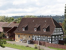
Farmhouse
|
|
Schleifenhan is part of the municipality in the Upper Franconian municipality of Itzgrund in the Coburg district .
geography
The wasteland on the Itz , a former mill property, is about 13 kilometers southwest of Coburg . The federal highway 4 leads past this place.
history
Schleifenhan was first mentioned in a document in 1233. Sleipenhagen was an old spelling. The mill stood at the confluence of the Schleifenhaner Bach (today the Püchitzer Bach) in the Itz at the height of the Schleiffenhayn forest.
Schleifenhan was on the border between the Kingdom of Bavaria and the Duchy of Saxe-Coburg and Gotha . In the state treaty negotiated between Bavaria's Prime Minister Maximilian von Montgelas and Prince Leopold von Sachsen-Coburg-Saalfeld from 1811, the territorially disputed Schleifenhan was awarded to Bavaria. From 1862 the place belonged to the newly created Bavarian District Office Staffelstein . In 1875 the wasteland had eighteen residents and ten buildings. The Protestant school and church were located in Gleußen , 2.5 kilometers away , to which the place belonged.
In 1925, fourteen people lived in Schleifenhan in two houses. In 1987 the wasteland comprised seven residents and two houses with two apartments.
On July 1, 1972, the Staffelstein district was dissolved. Schleifenhan has been part of the Coburg district since then . In the course of the Bavarian regional reform , Gleußen lost its independence as a municipality on May 1, 1978 and, like its district Schleifenhan, became a part of the municipality of Itzgrund.
Population development
|
Web links
Individual evidence
- ^ Walter Schneier: Coburg in the mirror of history . Neue Presse Coburg, 1985, p. 209,
- ↑ a b Kgl. Statistical Bureau (ed.): Complete list of localities of the Kingdom of Bavaria. According to districts, administrative districts, court districts and municipalities, including parish, school and post office affiliation ... with an alphabetical general register containing the population according to the results of the census of December 1, 1875 . Adolf Ackermann, Munich 1877, 2nd section (population figures from 1871, cattle figures from 1873), Sp. 1122. , Urn : nbn: de: bvb: 12-bsb00052489-4 ( digitized version ).
- ↑ a b Bavarian State Statistical Office (ed.): Localities directory for the Free State of Bavaria according to the census of June 16, 1925 and the territorial status of January 1, 1928 . Issue 109 of the articles on Bavaria's statistics. Munich 1928, Section II, Sp. 1158 . ( Digitized version ).
- ↑ a b Bavarian State Office for Statistics and Data Processing (Ed.): Official local directory for Bavaria, territorial status: May 25, 1987 . Issue 450 of the articles on Bavaria's statistics. Munich November 1991, DNB 94240937X , p. 299 . ( Digitized version ).
- ↑ K. Bayer. Statistical Bureau (Ed.): Directory of localities of the Kingdom of Bavaria, with alphabetical register of places . LXV. Issue of the contributions to the statistics of the Kingdom of Bavaria. Munich 1904, Section II, Sp. 1121 . ( Digitized version ).
- ↑ Bavarian State Statistical Office (ed.): Official place directory for Bavaria - edited on the basis of the census of September 13, 1950 . Issue 169 of the articles on Bavaria's statistics. Munich 1952, DNB 453660975 , Section II, Sp. 999 . ( Digitized version ).
- ^ Bavarian State Statistical Office (ed.): Official place directory for Bavaria . Issue 335 of the articles on Bavaria's statistics. Munich 1973, DNB 740801384 , p. 152 . ( Digitized version ).
