Köttel
|
Köttel
City of Lichtenfels
Coordinates: 50 ° 4 ′ 27 ″ N , 11 ° 9 ′ 59 ″ E
|
||
|---|---|---|
| Height : | 472-500 m | |
| Residents : | 92 (2016) | |
| Incorporation : | January 1, 1978 | |
| Postal code : | 96215 | |
| Area code : | 09576 | |
|
Location of Köttel in Bavaria |
||
|
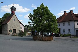
Köttel village square
|
||
Köttel is a district of the Upper Franconian city of Lichtenfels .
geography
The village is over ten kilometers away from the Lichtenfels core city at a junction of the LIF 22 district road between Lahm and the Siedamsdorf district of Weismain .
history
Köttel was first mentioned in 1265 as Codele . Until 1803 the place belonged to the monastery Langheim , until this was dissolved in the course of the secularization . With the community edict, the village , which had 130 inhabitants at the time, formed the community of Köttel in the Lichtenfels district court from 1818 with Eichig .
In 1950 Köttel had 151 inhabitants. On January 1, 1978, Köttel was incorporated into the city of Lichtenfels.
Attractions
- Brunnenhaus (built in the 18th century)
- Catholic chapel
In the list of architectural monuments in Lichtenfels (Upper Franconia) , three architectural monuments are identified for Köttel .
Others
The parish fair is celebrated on the second Sunday in November.


