
Theisau
|
Theisau
City of Burgkunstadt
Coordinates: 50 ° 7 ′ 39 ″ N , 11 ° 16 ′ 48 ″ E
|
||
|---|---|---|
| Height : | 288 (280-340) m above sea level NHN | |
| Residents : | 238 (Dec. 31, 2010) | |
| Incorporation : | January 1, 1977 | |
| Area code : | 09572 | |
Location of Theisau in Bavaria |
||

Theisau is a church village with 238 inhabitants and a district of Burgkunstadt in the Lichtenfels district .
Geographical location
Theisau is at 280- 340 m above sea level. NHN , at the southern end of the Steingraben, a short valley in the Upper Main region of Bruchschollenland . The official height is 289 m above sea level. NHN indicated. The B 298 runs through the village . The Main flows directly past the southern outskirts. The town center of Burgkunstadt is located around 2.5 kilometers west of Theisau.
history
.jpg)
- Historical views of the little church

Historical map of Theisau from 1851
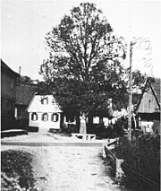
The old village of Theisau in 1934 on today's B289
.jpg)
.jpg)
Theisau was probably founded as a Slavic settlement at the end of the 1st millennium AD in predominantly Franconian dominion. The place was first mentioned in writing on April 8, 1251, in a document about a court case of the Archbishop of Bamberg, Heinrich I, on the upper hill near Mainklein. On the same day he also confirmed the donation of the Bamberg inheritance “Disou” to the Langheim monastery by “Ramung Henlein von Plassenberg”. The episcopal property register from 1348 shows that Theisau belonged to the Bishop of Bamberg as part of the Langheim Monastery until 1348 and was pledged to Iring von Redwitz .
On January 7, 1698, the first village and community ordinance of Theisau was issued by the then Oberamtmann zu Weismain, "His most gracious gentlemen, Mr. Heinrich Christoph Heuslein von Eyßenheimb and Mr. Johann Nikolaus Förtschens, currently Bailiff of Burgkunstadt". In order to enforce the ordinances set out in it, a Schultheyß (mayor) and a village master (local guide) were appointed.
After secularization, Theisau came to the Altenkunstadt parish. Around 55 years later, in 1855, the village became part of the Burgkunstadt parish. The neo-Gothic chapel in Theisau was built around 1880 and presumably consecrated to Mary , the Mother of God, on May 15, 1881 . Theisau's patron saint is St. John Nepomuk , who was venerated in the village even before his canonization in 1729. Evidence of this u. a. a sandstone figure with the inscription 1722, which is still standing at the passage, and a wooden figure on the church facade from the second half of the 18th century. The two bells were donated by Georg Schnap from Pfaffendorf and Freiherr von Redwitz from Maineck .
The Theisau Riding and Driving Club was founded on November 24, 1972.
On January 1, 1977 Theisau was incorporated into Burgkunstadt. Until then, the village and Mainklein formed a community.
Population development
The table shows the population development of Theisau based on individual data.
| year | Residents | source |
|---|---|---|
| 1803 | ~ 160 | |
| 1987 | 294 | |
| 2001 | 282 | |
| 2002 | 282 | |
| 2003 | 277 | |
| 2004 | 275 | |
| 2005 | 271 | |
| 2006 | 272 | |
| 2007 | 267 | |
| 2008 | 260 | |
| 2009 | 249 | |
| 2010 | 238 |
Individual evidence
- ↑ a b c d e Annual report of the city of Burgkunstadt from 2010 , publish.kommonline-gmbh.de, accessed on December 28, 2011
- ↑ Theisau in Bayernviewer , geodaten.bayern.de, accessed on October 12, 2019
- ↑ a b c d e history of the village of Theisau , burgkunstadt.eu, accessed on December 28, 2011
- ↑ a b c d e f g h Franz Wenzl: The districts of the city of Burgkunstadt with pictures from days gone by. Geiger Verlag, Horb am Neckar 1991, ISBN 3-89264-247-8 , p. 64 ff.
- ^ History of the Reit- und Fahrverein Theisau ( Memento from March 4, 2011 in the Internet Archive ), rufv-burgkunstadt-theisau.de, accessed on December 28, 2011
- ^ Theisau genealogical site directory , gov.genealogy.net, accessed on December 28, 2011
- ↑ a b c Annual report of the city of Burgkunstadt from 2006 , publish.kommonline-gmbh.de, accessed on December 28, 2011
- ↑ a b c Annual report of the city of Burgkunstadt from 2007 , publish.kommonline-gmbh.de, accessed on December 28, 2011
Web links

Burgkunstadt | Just | Ebneth | Floor wood | Garden Red | Grove pond | Hainzendorf | Kaltenreuth | Little church | Lopphof | Mainklein | Mainroth | Meuselsberg | New ponds | Neuses am Main | Pfaffeggetten | Reuth | Theisau | Weidnitz | Wildenroth