Burkheim (Altenkunstadt)
|
Burkheim
Borkum ( ofr. ) community Altenkunstadt
Coordinates: 50 ° 6 ′ 50 ″ N , 11 ° 12 ′ 8 ″ E
|
|
|---|---|
| Height : | 318 m above sea level NHN |
| Residents : | 259 (Jun 30, 2013) |
| Incorporation : | January 1, 1977 |
| Postal code : | 96264 |
| Area code : | 09572 |
Burkheim is a village with around 260 inhabitants in around 50 houses. It belongs to the municipality of Altenkunstadt in the district of Lichtenfels in the west of the administrative district of Upper Franconia in Bavaria. The place is at the foot of the Kordigast , embedded in the valley of the gray monks and adjacent to the Külmitz . The Kapellenbach flows past the northern edge of the village. The street village is predominantly rural and agricultural.
history
Middle Ages and early modern times
When Burkheim was founded is unclear. It was first mentioned in writing as "Wirkheim" in a deed of donation from Bamberg Bishop Eckbert von Andechs-Meranien to the Langheim monastery in 1230. Over the centuries, the name and its spelling changed slightly: "Würckheim" (1317), "Würrekheim "(1318)," Burckheim "(1337)," Burcheimb "(1358) and" Purckheim "(1520).
In the late Middle Ages, Burkheim was largely unaffected by major wars such as the Hussite invasions in 1430, the Peasants 'War of 1525 and the Thirty Years' War . In contrast to other Langheim villages, no records of any war events were kept about Burkheim.
As a result of the construction project of a water pipe, which was revolutionary for the time, the village was supplied with running water from the Kordigast from 1666 . The line was built by the villagers. It was also the task of every household to manufacture a wooden pipe and make it available for the construction of the water pipe. The wooden pipes were replaced by iron pipes in 1894 and these were replaced by cast iron pipes in 1954, together with the construction of the elevated tank .
19th century until today
Around 1801 Burkheim was still part of the Bamberg Monastery. The fiefs and the bailiwick belonged to the Langheim monastery . The pastor of Altenkunstadt also had property in Burkheim, as the parish was already in Altenkunstadt at that time. Also Weismain and Lichtenfels there had fiefs . From 1818 Burkheim was a separate municipality, with Tauschendorf as the only other district. The mayor was a volunteer.
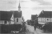
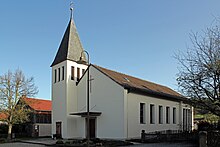
After Burkheim had had a fresh water pipeline since 1666, a sewage system and sewer system were built in 1953. Through the physical and financial contribution of the residents, a school was built in 1958 at the eastern end of the village. The old chapel was torn down in 1964 and a new one was built by 1966 at the endeavors of the chapel building association founded in 1962. Its first renovation, in which the facade was renewed, took place in 1989.
Almost 150 years after it was founded, the municipality of Burkheim was incorporated into Altenkunstadt on January 1, 1977 as part of the municipal reform. Since then, the school-age children of Burkheim have been attending the Altenkunstadter school, and the village's own school operations have been terminated. Between 1988 and 1994, the village was renewed at the same time as the state road that ran through the village was expanded. In 1996 the district horticultural show was held in the village, which attracted around 15,000 visitors. In 1998 Burkheim was awarded the gold medal in the competition Our village should become more beautiful - our village has the future as one of three Bavarian villages at federal level.
Population development
| year | Residents | estate | Source: |
|---|---|---|---|
| 1818 | 161 | 35 | |
| 1820 | 172 | ||
| December 01, 1910 | 248 | ||
| 1933 | 232 | ||
| 1939 | 209 | ||
| 1950 | 261 | ||
| 1961 | 262 | ||
| 1970 | 274 | ||
| 1977 | 252 | ||
| 1987 | 212 | ||
| 1995 | 226 | ||
| 2005 | 265 | ~ 50 | |
| 2010 | 269 | ~ 50 | |
| 2011 | 265 | ~ 50 | |
| 2012 | 267 | ~ 50 | |
| 2013 | 259 | ~ 50 |
religion
Of the 267 inhabitants in July 2013, approx. 76% (197) were Roman Catholic, approx. 15% (40) Protestant and approx. 9% (22) were of other faith or non-denominational.
societies
- Voluntary fire brigade , founded on October 19, 1890 by Johann Deuber and 28 other men.
- Fruit and horticultural association and its youth group, the "Grashüpfer" (founded in 1996)
- Kapellenbauverein Burkheim, founded on September 26, 1962.
Personalities
- Franz-Joseph Ahles (1869–1939), German poet; you can see the location of his former house and his memorial stone in Burkheim, the main street of Burkheim is named after him.
literature
- Josef Motschmann: Altenkunstadt - home between Kordigast and Main . Altenkunstadt community, Altenkunstadt 2006, DNB 982676182 .
- Erich Walter: Mountain and Village - Kordigast and Burkheim . Government of Upper Franconia, Bayreuth 1999, DNB 956116515 .
- Josef Schröder: Burkheim - Altenkunstadt community in the Lichtenfels district - a village and its inhabitants. Lichtenfels District Office, Lichtenfels 1998.
- Josef Schröder: Burkheim - a village and its inhabitants. District Office Lichtenfels, Lichtenfels 1995, DNB 94681189X .
Web links
Individual evidence
- ↑ a b c d Walter: Berg und Dorf ... 1999, pp. 47–53.
- ↑ a b c History of the Burkheim district , altenkunstadt.de, accessed on September 26, 2012.
- ↑ a b c d e f g h i j k Schröder: Burkheim - a village and its inhabitants. 1995, pp. 4-9.
- ↑ a b Motschmann: Altenkunstadt - home between Kordigast and Main. 2006, p. 56.
- ↑ a b c Federal Statistical Office (ed.): Historical municipality directory for the Federal Republic of Germany. Name, border and key number changes in municipalities, counties and administrative districts from May 27, 1970 to December 31, 1982 . W. Kohlhammer, Stuttgart and Mainz 1983, ISBN 3-17-003263-1 , p. 694 .
- ↑ Much has happened in Burkheim , brochure on the village beautification measures between 1995 and 1998, oO, 1998, 6 pages
- ↑ AH Hönig: Topographical-alphabetical handbook on the cities, markets, villages, hamlets, mills and wastelands in the Upper Main District . Bayreuth 1820 ( full text in the Google book search).
- ^ Municipal directory Germany 1900 - Lichtenfels district office , gemeindeververzeichnis.de, accessed on February 13, 2014
- ↑ a b Michael Rademacher: German administrative history from the unification of the empire in 1871 to the reunification in 1990. Lichtenfels district. (Online material for the dissertation, Osnabrück 2006).
- ↑ a b c Motschmann: Altenkunstadt - home between Kordigast and Main. 2006, p. 183.
- ↑ Bavarian State Office for Statistics and Data Processing (Ed.): Official local directory for Bavaria, territorial status: May 25, 1987 . Issue 450 of the articles on Bavaria's statistics. Munich November 1991, DNB 94240937X , p. 317 ( digitized version ).
- ↑ Official Gazette of Altenkunstadt, No. 7/2010, p. 6. (No longer available online.) Formerly in the original ; accessed on February 22, 2016 . ( Page no longer available , search in web archives )
- ↑ Official Journal of the Altenkunstadt Community, No. 7/2011, p. 4. (PDF file; 4.96 MB)
- ↑ a b Official Gazette of the Altenkunstadt Community, No. 7/2012, p. 3. (PDF file; 3.44 MB)
- ↑ Official Gazette of the Altenkunstadt Community, No. 7/2013, page 3 (PDF; 2.8 MB)


