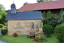
Tauschendorf (Altenkunstadt)
|
Exchange village
community Altenkunstadt
Coordinates: 50 ° 6 ′ 18 ″ N , 11 ° 11 ′ 41 ″ E
|
||
|---|---|---|
| Height : | 349 m | |
| Residents : | 23 (Jun 30, 2013) | |
|
Location of Tauschendorf in Bavaria |
||
Tauschendorf is a hamlet with 23 inhabitants and is part of the Altenkunstadt community in the Lichtenfels district .
Geographical location
The hamlet is located at the northern, open end of a short, nameless valley immediately northwest of the Kordigast at 351–367 m above sea level. NN . The Tauschendorf Bach flows through Tauschendorf and flows into the Kapellenbach in Burkheim ; this flows through the valley of the gray monks . There is a small ski lift at the end of the Tauschendorfer Valley .
history
When Tauschendorf was founded is unclear. The first documentary mention was in 1147/1148 in a papal confirmation for the Langheim monastery about the tithe in "Tuschendorff".
In 1801 it belonged to Weismain and gave tithe and other taxes there . Ecclesiastically it was under the monastery of Langheim, which also held the feudal and bailiwick rule .
From 1818 to 1977 Replace village belonged to the only other district to the municipality Burkheim that in the course of municipal reform was incorporated on 1 January 1977. according Altenkunstadt.
Population development
The table shows the population development of Tauschendorf.
| year | Residents | estate | Source: |
|---|---|---|---|
| 1818 | 64 | 13 | |
| 1820 | 57 | ||
| 1832 | 60 | 12 | |
| 1950 | 55 | ||
| 1977 | 49 | ||
| 1987 | 26th | ||
| 2005 | 41 | ~ 15 | |
| 2010 | 34 | ~ 15 | |
| 2011 | 34 | ~ 15 | |
| 2012 | 23 | ||
| 2013 | 23 |
religion
In July 2013, of the 23 inhabitants, approx. 78% (18) were Roman Catholic, approx. 22% (5) Protestant and 0% (0) non-religious or non-denominational.
societies
- Ski- und Wanderfreunde Kordigast eV , operates the ski lift southwest of Tauschendorf
literature
- Josef Motschmann: Altenkunstadt - home between Kordigast and Main . Altenkunstadt community, Altenkunstadt 2006.
Web links
Individual evidence
- ↑ Motschmann 2006, p. 183
- ↑ Brief description from Tauschendorf , altenkunstadt.de, accessed on December 29, 2011
- ^ Dieter George: Lichtenfels; The old circle . Historical book of place names of Bavaria. Upper Franconia. Volume 6: Lichtenfels. Commission for Bavarian State History, Munich 2008, ISBN 978-3-7696-6862-9 , p. 152.
- ↑ a b c d Motschmann 2006, p. 184
- ↑ a b Motschmann 2006, p. 56
- ^ Federal Statistical Office (ed.): Historical municipality directory for the Federal Republic of Germany. Name, border and key number changes in municipalities, counties and administrative districts from May 27, 1970 to December 31, 1982 . W. Kohlhammer GmbH, Stuttgart and Mainz 1983, ISBN 3-17-003263-1 , p. 694 .
- ↑ AH Hönig: Topographical-alphabetical handbook on the cities, markets, villages, hamlets, mills and wastelands in the Upper Main District . Bayreuth 1820 ( full text in the Google book search).
- ^ Joseph Anton Eisenmann, Karl Friedrich Hohn: Topo-geographical-statistical lexicon from the Kingdom of Bavaria . Erlangen 1832, p. 1194 ( full text in Google Book Search).
- ↑ Bavarian State Office for Statistics and Data Processing (Ed.): Official local directory for Bavaria, territorial status: May 25, 1987 . Issue 450 of the articles on Bavaria's statistics. Munich November 1991, DNB 94240937X , p. 317 ( digitized version ).
- ^ Official Journal of the Altenkunstadt Community, No. 7/2010, p. 6
- ↑ Official Journal of the Altenkunstadt Community, No. 7/2011, p. 4 (PDF; 5.2 MB)
- ↑ Official Journal of the Altenkunstadt Community, No. 7/2012, page 3 (PDF; 3.6 MB)
- ↑ a b Official Gazette of the Altenkunstadt Community, No. 7/2013, page 3 (PDF; 2.8 MB)


