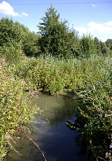
Aunkirchen brook
| Aunkirchen brook | ||
|
The Aunkirchner Bach in 2013 |
||
| Data | ||
| Water code | DE : 17496 | |
| location | Vilshofen on the Danube , Passau district , Lower Bavaria , Germany | |
| River system | Danube | |
| Drain over | Vils → Danube → Black Sea | |
| source | in the district of Passau 48 ° 33 ′ 3 ″ N , 13 ° 6 ′ 28 ″ E |
|
| Source height | 365 m | |
| muzzle | Aunkirchen coordinates: 48 ° 36 '32 " N , 13 ° 8' 12" E 48 ° 36 '32 " N , 13 ° 8' 12" E
|
|
| length | 8.3 km | |
| Catchment area | 16.43 km² | |
The Aunkirchner Bach is a brook in Aunkirchen , a district of the Bavarian town of Vilshofen on the Danube . It rises in Beutelsbach and flows into the Vils in the village of Aunkirchen , which flows into the Danube . The earlier name was Beutels-Bach .
The stream has a total length of 8.82 km and a catchment area of 16.43 km². The course of the stream was straightened as part of the land consolidation work in the early 1970s, but was renatured again almost 30 years later, in 1998.
Individual evidence
- ↑ a b c Bavarian State Office for the Environment: Water directory Bavaria. Directory of brook and river areas in Bavaria. River Isar to Inn. Status 2012 , p. 71 (PDF file, accessed September 25, 2015)
