Altenmarkt (Fürstenzell)
|
Altenmarkt
Fürstenzell market
Coordinates: 48 ° 33 ′ 17 ″ N , 13 ° 20 ′ 40 ″ E
|
||
|---|---|---|
| Incorporation : | January 1, 1972 | |
|
Location of Altenmarkt in Bavaria |
||
|
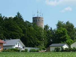
The striking water tower
|
||
Altenmarkt is a district of the Fürstenzell market in the Lower Bavarian district of Passau . Until 1972 it formed an independent municipality.
location
Altenmarkt is located in the Neuburg Forest on State Road 2118 about three kilometers northeast of Fürstenzell.
history
The Altenmarkt settlement was built as a planned facility for the county of Neuburg between 1523 and 1674. In the land register of 1674 it is still called in the market from “Mark”, the border. Until 1805, Altenmarkt belonged to the Steinharrer Amt and to the Rehschaln Obmannschaft of the County of Neuburg.
The municipality of the same name emerged from the Altenmarkt tax district and was assigned to the reorganized Passau II district court in 1838. On April 10, 1866, the parish name Hirschbrunn was canceled. On October 1, 1957, the Edlwagner wasteland was added from the Fürstenzell community. On May 5, 1969, the district of Bamesreut was assigned to the district of Jägerwirth , Bernau, Neuhaus and Reitfellner came to Obereichet, Gaderer, Götzenmann and Zöls to Haunreut, Hillermeier, Kollbrunn and Reitmeier to Gföhret, Lamplmann and Schiffbauer to Altenmarkt, Lohmann and Stapfl to Rehschaln and Oberreut to little ones. The municipality of Altenmarkt came to market Fürstenzell on January 1, 1972 as part of the regional reform in Bavaria .
societies
- Farmers' Association Altenmarkt
- Horticultural Association Altenmarkt
- Hunting companions Altenmarkt
literature
- Josef Hofbauer: The county of Neuburg am Inn . I / XX in the Historical Atlas of Bavaria , Munich 1969, ISBN 3-7696-9800-2 ( digitized version )
- Ludwig Veit : Passau. The Hochstift . I / XXXV in the Historical Atlas of Bavaria , Laßleben, Kallmünz 1978, ISBN 3-7696-9896-7 ( digitized version )

