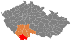
Okres Český Krumlov
| Okres Český Krumlov | |
|---|---|
| Kraj | Jihočeský kraj |
| surface | 1,614.66 km² |
|
Inhabitants • Population density |
61,381 ( January 1, 2019 ) 38 inhabitants / km² |
|
Municipalities • of which cities • of which Městyse |
47 6 4 |
| LAU 1 | CZ0312 |
|
Vehicle registration number (issued until 2001) |
CK |

|
|
Okres Český Krumlov (German district Krumau ) is located in the southernmost part of the Czech Republic in the Jihočeský kraj (South Bohemia). The area is 1,615 km². 61,000 inhabitants live in the 47 municipalities with 221 districts and 302 basic settlement units (as of 2015). The population density of around 38 inhabitants / km² is the lowest in the Czech Republic. More than half of the population lives in the six towns in the district. Most of the communities are at an altitude of around 700 meters above sea level. M.
The most important branches of industry include paper processing and manufacture, mechanical engineering and the construction industry. Graphite and granulite as well as peat are promoted. In agriculture, grain and fodder are grown and cattle is raised. Forestry also plays an important role. Unemployment is 8.7%.
In the course of the downsizing of the military training areas, the municipality of Polná na Šumavě was established in 2016 .
Attractions
- City of Český Krumlov , UNESCO World Heritage
- Zlatá Koruna Monastery ( former Cistercian Goldenkron Abbey )
- Vyšší Brod Monastery ( Cistercian Monastery Hohenfurth )
- Rožmberk Castle ( Rosenberg Castle )
- Gothic church in Dolní Dvořiště ( Unterheid ), pilgrimage church in Kájov ( Gojau ), churches in Malonty ( Meinetschlag ) and Rychnov nad Malší ( Reichenau an der Maltsch )
- Dívčí Kámen Castle ( Maidstein Castle Ruins )
- the highest observatory in Bohemia on the Kleť ( Schöninger ) at 1070 m above sea level. M.
The district has many natural monuments, most of which are located in the Bohemian Forest and the Gratzener Uplands . The highest point is at 1332 meters (Hochficht), the lowest point on the Vltava River near Vrábče ( Prabsch , 420 meters). The most important river is the Vltava with the Lipno reservoir , the highest dam in the Czech Republic (726 meters above sea level). Another important river and source of drinking water is the Malše ( Maltsch ) with the Soběnov dam. In the many nature parks you can find numerous rare plants and trees up to 400 years old and 50 meters high.
cities and communes
Benesov nad Černou ( German Beneschau ) - Besednice ( Bessenitz ) - Bohdalovice ( Podesdorf ) - Boletice ( Polletitz ; TÜP) - Brloh ( Berlau ) - Bujanov ( Angern ) - Černá v Pošumaví ( Schwarzenbach ) - Cesky Krumlov ( Cesky Krumlov ) - Dolní Dvořiště ( Unterhaid ) - Dolní Třebonín ( Unterreitenstein ) - Frymburk ( Friedberg ) - Holubov ( Hollubau ) - Horní Dvořiště ( Oberhaid ) - Horní Planá ( Oberplan ) - Hořice na Šumavě ( Höritz ) - Chlumec ( Chunzen ) - Chvalšiny ( Kalsching ) - Kájov ( Gojau ) - Kaplice ( Kaplitz ) - Křemže ( Krems ) - Lipno nad Vltavou ( lips ) - Loučovice ( Kienberg ) - Malonty ( Meinetschlag ) - Malšín ( Malsching ) - Mirkovice ( Mirkowitz ) - Mojné ( Moyne ) - Netřebice ( Netrobitz ) - Nová Ves ( Neudorf bei Berlau ) - Omlenice ( Groß Umlowitz ) - Pohorská Ves ( Theresiendorf ) - Polná na Šumavě ( Stone in the Bohemian Forest ) - Přední Výtoň ( Front Heuraffl ) - Přídolí ( Priethal ) - Přísečná ( Prisberk ) - Rožmavouk ( Rosenberg ) - Rožmitál na Šumavě ( Rosentha l ) - Soběnov ( Oemau ) - Srnín ( Sirnin ) - Střítež ( Tritesch ) - Světlík ( Kirchschlag ) - Velešína ( Weleschin ) - Větřní ( bettors ) - Věžovatá Pláně ( Thurmplandles ) - Vyšší Brod ( Hohenfurth ) - Zlatá koruna ( Golden Crown ) - Zubčice ( Subschitz ) - Zvíkov ( Zwickau )
Individual evidence
- ↑ http://www.uir.cz/okres/3302/Cesky-Krumlov
- ↑ http://www.uir.cz/okres/3302/Cesky-Krumlov
- ↑ http://www.uir.cz/okres/3302/Cesky-Krumlov
- ↑ http://zpravy.idnes.cz/v-cesku-vzniknou-ctyri-nove-obce-prvniho-starostu-si-zvoli-i-libava-11v-/domaci.aspx?c=A120213_120805_domaci_jw
Web links
- Homepage of ePUSA (cz)
Coordinates: 48 ° 44 ' N , 14 ° 18' E