Věžovatá Pláně
| Věžovatá Pláně | ||||
|---|---|---|---|---|
|
||||
| Basic data | ||||
| State : |
|
|||
| Region : | Jihočeský kraj | |||
| District : | Český Krumlov | |||
| Area : | 480 ha | |||
| Geographic location : | 48 ° 46 ' N , 14 ° 25' E | |||
| Height: | 695 m nm | |||
| Residents : | 156 (Jan 1, 2019) | |||
| Postal code : | 382 32 | |||
| License plate : | C. | |||
| traffic | ||||
| Street: | Kaplice-nádraží - Věžovatá Pláně | |||
| structure | ||||
| Status: | local community | |||
| Districts: | 2 | |||
| administration | ||||
| Mayor : | Josef Mach (as of 2018) | |||
| Address: | Věžovatá Pláně 1 382 32 Věžovatá Pláně |
|||
| Municipality number: | 536300 | |||
| Website : | www.vezovataplane.cz | |||
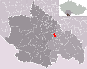
| Location of Věžovatá Pláně in the Český Krumlov district | ||||

|
||||
Věžovatá Pláně (German Thurmplandles ) is a municipality with 115 inhabitants in the Czech Republic . It is located seven kilometers northwest of Kaplice and belongs to the Okres Český Krumlov .
geography
The place is located in the Poluška Mountains. To the west lies the Jílecký potok valley . Neighboring towns are Dolní Pláně in the east, Horní Pláně in the southeast, Brusnické Chalupy in the south, Osek in the southwest, Sedlice in the west and Malčice and Zubčice in the north.
Community structure
The municipality Věžovatá Pláně consists of the districts Dolní Pláně ( Unterplandles ) and Věžovatá Pláně as well as the layers Horní Pláně ( Oberplandles ) and Buchtice ( Buchtitz ).
Neighboring communities
| Mirkovice | Zubčice | Netřebice |
| Přídolí |

|
Střítež u Kaplice |
| Rožmitál na Šumavě |
history
The first written mention of the village of Planje , which belongs to the Poreschin domain , dates back to 1366. The district of Dolní Pláně, which has been documented since 1358, is even older. In the century, the village passed into the possession of the Lords of Drchowetz on Großumlowitz .
In 1785 a wooden church and a pastoral care station were built under the patronage of Hohenfurth Monastery . In 1788 the school, which is obligatory for every parish, was built. In 1800 the conversion of St. Anne's Church into a stone structure began, and in 1870 a brick tower was built instead of the wooden one. From 1857 Věžovatá Pláně was an independent parish.
From 1841 the name Thurnplanles is proven, from which Thurmplandles developed a little later. Until the end of the patrimonial rule in 1850, Krummau belonged to the manor .
In 2003, Věžovatá Pláně became the first Czech municipality to join the Climate Alliance and Mayor Josef Mach declared that it would not use electricity from the controversial Temelín nuclear power plant . On the initiative of Mach, who is one of the leading Temelín opponents in the Czech Republic, an information and training center for solar energy was set up in Věžovatá Pláně in the same year, supported jointly by Austrian and Czech environmental groups.
There are hiking opportunities in the scenic surroundings of the village, and in winter there are cross-country trails and a ski lift is operated.
Attractions
- The St. Anna Church ( Kostel svaté Anny ) was built in 1800 instead of an older, small wooden church.
Web links
- Website of the municipality on vezovataplane.cz (Czech).
- Věžovatá Pláně . In: Online encyclopedia encyklopedie.ckrumlov.cz about Krummau .
Individual evidence
- ↑ http://www.uir.cz/obec/536300/Vezovata-Plane
- ↑ Český statistický úřad - The population of the Czech municipalities as of January 1, 2019 (PDF; 0.8 MiB)
- ↑ http://www.uir.cz/casti-obce-obec/536300/Obec-Vezovata-Plane
- ^ Gerald Schubert: Czech-Austrian cooperation project: New center for solar energy in South Bohemia. Radio Praha, radio.cz, September 3, 2003 (German).


