Holubov
| Holubov | ||||
|---|---|---|---|---|
|
||||
| Basic data | ||||
| State : |
|
|||
| Region : | Jihočeský kraj | |||
| District : | Český Krumlov | |||
| Area : | 1556 ha | |||
| Geographic location : | 48 ° 53 ' N , 14 ° 19' E | |||
| Height: | 512 m nm | |||
| Residents : | 1,085 (Jan 1, 2019) | |||
| Postal code : | 382 03 | |||
| License plate : | C. | |||
| traffic | ||||
| Street: | Křemže - Český Krumlov | |||
| Railway connection: | České Budějovice – Černý Kříž | |||
| structure | ||||
| Status: | local community | |||
| Districts: | 3 | |||
| administration | ||||
| Mayor : | Roman Kudláček (as of 2018) | |||
| Address: | Holubov 242 38 203 Křemže |
|||
| Municipality number: | 545490 | |||
| Website : | www.holubov.cz | |||
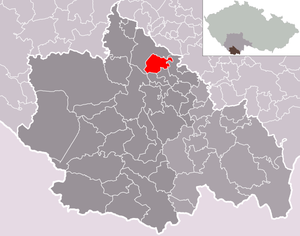
| Location of Holubov in the Český Krumlov district | ||||

|
||||
Holubov (German Hollubau ) is a municipality in the Czech Republic . It is located 15 kilometers southwest of Budweis and belongs to the Okres Český Krumlov .
geography

The place is at 512 m above sea level. M. at the northern foot of the Blanský les on the right side above the valley of the Křemžský potok . The České Budějovice – Černý Kříž railway runs through Holubov . Separated by the valley of the Křemžský potok rises the Háj (532 m) in the north. To the east is the Dívčí Kámen castle . In the south is the Jiříčkův vrch (757 m) and in the southwest above Krasetín the Kleť (1083 m), to which a cable car runs from Podluží.
Neighboring towns are Mříč in the north, Třísov and Nad Vsí in the south-east, Krasetín in the south-west, Holubovský Mlýn in the south-west, Chlum u Křemže and Křemže in the north-west.
Community structure
The municipality Holubov consists of the districts Holubov, Krasetín ( Krassetin ) and Třísov ( Tschisow ). Basic settlement units are Holubov, Krasetín, Nad Vsí, Planinka ( Adolfsthal ), Podluží and Třísov. Holubov also includes the hamlets and strata Podhradský Ostrov, Horní Moučka, Holubovský Mlýn and Vyhlídka.
The municipality is divided into the cadastral districts of Hulubov and Třísov.
Neighboring communities
| Křemže | ||

|
Dolní Třebonín | |
| Kájov | Srnín | Zlatá Koruna |
history
The first news about Holubow comes from the Rosenberger's property book from 1379. The place was subordinate to the Maidstein estate belonging to the Krummau lordship . Holubau formed a municipality from the middle of the 19th century that belonged to the judicial district of Krumau in the Krumau district .
The Rosenbergs were followed by the Eggenbergs and the Schwarzenbergs . After the end of patrimonial Holubov became an independent municipality in 1850.
Culture and sights
- Dívčí Kámen Castle
- Kleť with a stone lookout tower and observatory
- Nature reserves Holub Over serpentinite ( Holubovské hadce , a 1972 nature reserve declared 15.68 hectares area) and BORINKA (6.68-hectare nature reserve since 1990)
- Horní luka natural monument ("mountain meadow")
- Celtic oppidum Třísov with an educational trail to Dívčí Kámen castle
- Ironworks Adolf
- Iron railway bridge over the Křemžský potok ( Krems brook )
Web links
- The municipality's website at holubov.cz (Czech).
- Holubov . In: Online encyclopedia encyklopedie.ckrumlov.cz about Český Krumlov (information about the municipality).
Individual evidence
- ↑ http://www.uir.cz/obec/545490/Holubov
- ↑ Český statistický úřad - The population of the Czech municipalities as of January 1, 2019 (PDF; 0.8 MiB)
- ↑ http://www.uir.cz/casti-obce-obec/545490/Obec-Holubov
- ↑ http://www.uir.cz/zsj-obec/545490/Obec-Holubov
- ↑ http://www.uir.cz/katastralni-uzemi-obec/545490/Obec-Holubov
- ↑ Blanský les nature reserve . In: Online encyclopedia encyklopedie.ckrumlov.cz about Krummau (with the protected areas Bořinka, Holubov Serpentinite and Horní Luka).


