Křemžský potok
|
Křemžský potok Brložský potok, Kremser Bach |
||
|
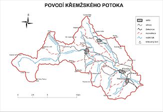
The catchment area of the Křemžský potok |
||
| Data | ||
| Water code | CZ : 1-06-01-195 | |
| location | Czech Republic | |
| River system | Elbe | |
| Drain over | Vltava → Elbe → North Sea | |
| source | northwest of the Chlum in the Bohemian Forest foreland 48 ° 53 '25 " N , 14 ° 4' 21" E |
|
| Source height | 950 m nm | |
| muzzle | at the Dívčí Kámen castle in the Vltava Coordinates: 48 ° 53 ′ 25 ″ N , 14 ° 21 ′ 31 ″ E 48 ° 53 ′ 25 ″ N , 14 ° 21 ′ 31 ″ E |
|
| Mouth height | 424 m nm | |
| Height difference | 526 m | |
| Bottom slope | 18 ‰ | |
| length | 30 km | |
| Catchment area | 126.6 km² | |
| Drain |
MQ |
940 l / s |
|
The Křemžský potok near the Dívčí Kámen castle |
||
The Křemžský potok , also Brložský potok , Dobročkovský potok , Markův potok or Rybářský potok (German Kremser Bach , in sections also Chumbach , Dobruschbach , Tischner Bach , Berlauer Bach ) is a left tributary of the Moldau / Vltava in the Czech Republic .
course
The Křemžský potok rises north of the Chlumanská hájovna ( Chumheger ) desert on the Boletice military training area . Its source is located at the north-western foot of the Chlum ( Großer Chumberg , 1191 m nm) or west of the Chlum ( Kleiner Chumberg , 1025 m nm) in the Českokrumlovská vrchovina ( Krummauer hill country ) belonging to the Bohemian Forest foreland . The stream flows on its upper course in a wide and flat valley, first past the Chlumské Domky ( Chumhäuser ) desert and the village of Markov ( Markus ) to the north. At Kamenný vrch ( Steinberg , 833 m nm), around which it flows to the west and north, the stream changes its direction to the east. Above the valley of the Křemžský potok lie the desert areas Stará Huť ( Althütten ), Jakšův Mlýn ( Jaklmühle ), Sádlno ( Zodl ) and Rovence ( Rubenz ) as well as the villages Tisovka ( Neuberg ) and Mackova Lhota ( Mosetstift ). At Ktiš -Pila the brook leaves the military area and is dammed at the Ktišský Mlýn ( table mill ) in the Ktišský rybník pond. The further course of the Křemžský potok leads in numerous meanders past Březovík ( Oxbrunn ) and Nová Hospoda, where it takes a northerly direction on the Červený vrch for one and a half kilometers to Dobročkov . This meandering, natural section is protected as a PR Dobročkovské Hadce nature reserve . From the confluence of the Smědečský potok, the Křemžský potok flows, again in an easterly direction, into the protected landscape area Blanský les . The brook flows through Brloh past Kuklov ( Kugelweid ), the Kuglvajt castle ruins , the Slavic fortifications U Ondřeje , Kovářov ( blacksmiths ) and Cvrčkův Mlýn ( Gillmühle ) . The southern slope of the Stráže hill (620 m nm) on the outskirts of Brloh is protected as a natural monument PP Na Stráži .
The further course of the Křemžský potok leads through a sole valley past Honza u Kapličky, U Bajsů v Luži, U Bychů, Rychtářov ( judges' houses ), U Bětáků, Rojšín ( Roisching ), Lhotka ( Mehlhiedl ), U Pekaretan, Klimšův Mlýn, , U Šimečků, U Běhounků, Vinná ( Binaberg ), Červený Mlýn ( Rothemühle ) Markytan, Štrouba, Stupenské Jednoty, Hamry, U Kadlece, Vackův Mlýn, Chlumeček ( Chlumetschek ) Pasíčka, Chlum, Chlumský Mlýn and Křemže by the Křemžská kotlina ( Kremser Basin ) to the southeast. At the mouth of the Olešnice near U Pekárků is the natural monument PP Šimečkova stráň .
At its lower reaches the Křemžský potok forms a notched valley. Its course continues in a south-easterly direction past Křemžský Mlýn, Beranův Mlýn and Holubovský Mlýn ( Hollubauer Mill ); the slope opposite the bend in the Holubovský Mlýn river is protected as a PR Bořinka nature reserve . At Holubov , the stream is bridged by the České Budějovice – Černý Kříž railway line. The towns of Planinka ( Adolfsthal ), Třísovský Hamr and Třísov ( Tschisow ) are located along the Křemžský potok . The PR Holubovské Hadce nature reserve is located on the slopes on both sides of the stream below Planinka . Then the Křemžský potok flows past the Třísov oppidum and the Dívčí Kámen castle . After 30 kilometers, the Křemžský potok flows into the Vltava west of the Podhradský farm ( Podhradky ) .
During the snowmelt in spring and after rainy days, the Křemžský potok is navigable on the 14 kilometers below Křemže. On some sections of the stream, river pearl mussel populations have been preserved.
Tributaries
- Chlumanský potok (r), near Tisovka
- Smědečský potok (l), near Dobročkov
- Janský potok (r), near Klimšův Mlýn
- Olešnice (l), at U Pekárků
- Lhotecký potok (r), near Červený Mlýn
- Chmelenský potok (l), near Vackův Mlýn
- Chlumecký potok (r), between Chlum and Křemže
- Krasetínský potok (r), near Holubov
- Mříčský potok (l), near Holubov
- Borský potok (l), in Planinka
- Dobrovodský potok (r), in Planinka
- Třísovský potok (r), near Třísov
Web links
Individual evidence
- ↑ a b c d e Vltava a její přítoky. Křemžský potok (Brložský, Dobročkovský, Markův, Rybářský potok) at kct-tabor.cz (Czech), accessed on November 9, 2019.
- ↑ http://www.ckrumlov.cz/cz1250/region/soucas/i_hydro.htm


