Bujanov
| Bujanov | ||||
|---|---|---|---|---|
|
||||
| Basic data | ||||
| State : |
|
|||
| Region : | Jihočeský kraj | |||
| District : | Český Krumlov | |||
| Area : | 1743 ha | |||
| Geographic location : | 48 ° 42 ' N , 14 ° 27' E | |||
| Height: | 670 m nm | |||
| Residents : | 563 (Jan. 1, 2019) | |||
| Postal code : | 382 41 to 382 91 | |||
| License plate : | C. | |||
| traffic | ||||
| Street: | Kaplice - Rožmitál na Šumavě | |||
| Railway connection: | Linz Hbf – České Budějovice | |||
| structure | ||||
| Status: | local community | |||
| Districts: | 4th | |||
| administration | ||||
| Mayor : | Luděk Detour (as of 2018) | |||
| Address: | Bujanov 26 382 41 Kaplice 1 |
|||
| Municipality number: | 545449 | |||
| Website : | www.bujanov.cz | |||
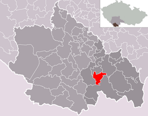
| Location of Bujanov in the Český Krumlov district | ||||

|
||||
Bujanov (German Angern ) is a municipality in the Okres Český Krumlov in the Czech Republic . It is located about ten kilometers southeast of Český Krumlov and belongs to the Jihočeský kraj region .
geography
Bujanov is located about seven kilometers southwest of Kaplice between the Vltava and Maltsch rivers . Neighboring towns are Omlenice in the north, Skoronice in the northeast, Rychnov nad Malší and Suchdol in the southeast, Rybník ( Zartlesdorf ) in the south, Hněvanov in the southwest and Rožmitál na Šumavě in the west. Austria is reached via the border crossing Wullowitz - Dolní Dvořiště , located seven kilometers south-east on European route 55 .
Community structure
The municipality Bujanov consists of the districts
- Bujanov ( Angern )
- Skoronice ( Gurenitz )
- Suchdol ( Suchenthal )
- Zdíky ( Stiegesdorf ).
Bujanov also includes the settlements Ježkov ( Jeschkersdorf ), Nažidla ( Einsiedl ), Pšenice ( Pschenitz ) and the extinct place Svinihlavy ( Zwinelag ). Basic settlement units are Bujanov, Nažidla, Skoronice, Suchdol and Zdíky.
The municipality is divided into the cadastral districts Suchdol u Bujanova and Zdíky.
Neighboring communities
| Omlenice | Kaplice | |
| Rožmitál na Šumavě |

|
|
| Dolní Dvořiště |
history
Angern was first mentioned in a document in 1347 when the knight Paul von Harrach gave a hat in Angern to Hohenfurt Monastery for the salvation of his mother's soul .
The connection from Angern to the Budweis – Linz – Gmunden horse-drawn railway was of economic importance . The first section from Budweis to Zartlesdorf ( Rybník ), where Angern stopped, was opened on September 7, 1827.
After the abolition of patrimonial Angern formed an independent municipality that belonged to the Kaplitz district authority . After Czechoslovakia was founded in 1918, Angern was given the official Czech place name Bujanov in 1923 .
As a result of the Munich Agreement , Bujanov / Angern was annexed to the German Reich in 1938 and belonged to the Kaplitz district in the Gau Oberdonau until 1945 . After the Second World War, Angern / Bujanov fell back to Czechoslovakia . The predominantly German population was expelled in 1946 .
On March 8, 2003, a serious bus accident occurred on the E 55 near Nažidla, in which 20 people died.
Attractions
- The horse-drawn railway museum is open on summer weekends.
- Louzek castle ruins ( Lauseck Castle )
- Brake block in Nažidla with (the location on the opposite side of the valley brake stone in Suchdol was 2019 untraceable)
Web links
- Bujanov . In: Online encyclopedia encyklopedie.ckrumlov.cz about Krummau .
- Website of the municipality on bujanov.cz (Czech).
- History of the parish on bujanov.cz (Czech).
Individual evidence
- ↑ http://www.uir.cz/obec/545449/Bujanov
- ↑ Český statistický úřad - The population of the Czech municipalities as of January 1, 2019 (PDF; 0.8 MiB)
- ↑ http://www.uir.cz/casti-obce-obec/545449/Obec-Bujanov
- ↑ http://www.uir.cz/zsj-obec/545449/Obec-Bujanov
- ↑ http://www.uir.cz/katastralni-uzemi-obec/545449/Obec-Bujanov
- ↑ Kastastralkarte on cuzk.cz (Czech).
- ↑ Muzeum koněspřežné Railways Museum of horse-drawn railway on bujanov.cz (Czech).
- ↑ The little Louzek Castle . In: Online encyclopedia encyklopedie.ckrumlov.cz about Krummau .

