Besednice
| Besednice | ||||
|---|---|---|---|---|
|
||||
| Basic data | ||||
| State : |
|
|||
| Region : | Jihočeský kraj | |||
| District : | Český Krumlov | |||
| Area : | 1612 ha | |||
| Geographic location : | 48 ° 47 ' N , 14 ° 34' E | |||
| Height: | 575 m nm | |||
| Residents : | 810 (Jan. 1, 2019) | |||
| Postal code : | 382 81 | |||
| License plate : | C. | |||
| traffic | ||||
| Street: | Kaplice -nádraží - Trhové Sviny | |||
| structure | ||||
| Status: | Městys | |||
| Districts: | 2 | |||
| administration | ||||
| Mayor : | Jaroslav Klein (as of 2018) | |||
| Address: | Náměstí 52 382 81 Besednice |
|||
| Municipality number: | 545414 | |||
| Website : | www.besednice.cz | |||
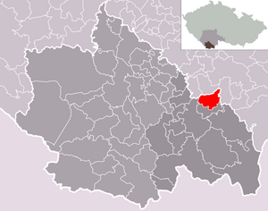
| Location of Besednice in the Český Krumlov district | ||||

|
||||
Besednice (German Bessenitz ) is a minor town in the Okres Český Krumlov in the Czech Republic . It is located about six kilometers southwest of Trhové Sviny and belongs to the Jihočeský kraj region .
geography
Besednice is located in the foothills of the Gratzener Uplands in the Chicken Mountains , which is part of the Soběnovská vrchovina National Park . Neighboring towns are Něchov ( Mechau ) in the north, Keblany and Mohuřice in the northeast, Slavče ( Slabs ) in the east, Klení ( Gollnetschlag ) in the southeast, Soběnov in the south, Pořešín in the southwest and Velešín in the northwest. The 869 m high Kohout ( Hahn ) rises to the southeast . The nature reserves "Vysoký Kámen" and "Ševcova hora" are nearby.
Community structure
The municipality Besednice consists of the districts Besednice ( Bessenitz ) and Malče ( Maltsche ), which at the same time also form cadastral districts. Besednice also includes the settlements of Bída and Buda.
Neighboring communities
| Svatý Jan nad Malší | Ločenice | |

|
Slavče | |
| Kaplice | Soběnov |
history
Bessenitz was first mentioned in 1395 when Heinrich III. von Rosenberg gave Besenicze to the parish church of St. Veit in Krumau , whose property it belonged to until the abolition of patrimonial rule in 1848. The St. Prokop Church was built in 1786 and a school opened in the same year, which was given a new building in 1833. From 1850 the place was part of the Schweinitz judicial district , which later became part of the Budweis district . In 1910 Bessenitz was elevated to a market town and the recording of the community chronicle began. Granite and brick processing were of economic importance.
After the establishment of Czechoslovakia in 1918, Bessenitz received the official Czech place name Besednice . After the Munich Agreement, Besednice remained with Czechoslovakia and from 1939 to 1945 belonged to the Budweis political district in the Protectorate of Bohemia and Moravia .
As a result of the Second World War, the German population was expelled in 1946 . After the political upheaval of 1989, measures were taken to improve the infrastructure. In 1995, the 600th anniversary was celebrated. In the same year Besednice won the third place in the competition “The most beautiful village in South Bohemia” and the award “The blue ribbon”. On October 10, 2006, it was given back the status of Městys .
Attractions
- town hall
- Baroque St. Prokop Church from 1786
- Rectory
- St. Nepomuk Chapel
- Natural monument (PP) Besednické vltavíny, the 28 hectare area on the eastern edge of the village has been protected since 1995. In the reserve there is an old clay pit, which is considered to be a rich place where Moldavites were found .
- Homesteads in the Bohemian peasant baroque
- Lookout tower on Slabošovka, west of the village
Web links
- Besednice . In: Online encyclopedia encyklopedie.ckrumlov.cz about Krummau .
Individual evidence
- ↑ http://www.uir.cz/obec/545414/Besednice
- ↑ Český statistický úřad - The population of the Czech municipalities as of January 1, 2019 (PDF; 0.8 MiB)
- ↑ http://www.uir.cz/casti-obce-obec/545414/Obec-Besednice
- ↑ http://www.uir.cz/katastralni-uzemi-obec/545414/Obec-Besednice
- ↑ http://territorial.de/bm/budweis/gem1940.htm

