
Rennertshofen
| coat of arms | Germany map | |
|---|---|---|

|
Coordinates: 48 ° 45 ' N , 11 ° 3' E |
|
| Basic data | ||
| State : | Bavaria | |
| Administrative region : | Upper Bavaria | |
| County : | Neuburg-Schrobenhausen | |
| Height : | 394 m above sea level NHN | |
| Area : | 93.1 km 2 | |
| Residents: | 4966 (Dec. 31, 2019) | |
| Population density : | 53 inhabitants per km 2 | |
| Postal code : | 86643 | |
| Primaries : | 08434, 08427, 08431, 09094 | |
| License plate : | ND, SOB | |
| Community key : | 09 1 85 153 | |
| Market structure: | 27 parts of the community | |
Market administration address : |
Marktstrasse 18 86643 Rennertshofen |
|
| Website : | ||
| Mayor : | Georg Hirschbeck ( CSU ) | |
| Location of the Rennertshofen market in the district of Neuburg-Schrobenhausen | ||
  |
||


.jpg)
Rennertshofen is a market in the Upper Bavarian district of Neuburg-Schrobenhausen .
geography
location
Rennertshofen in the Ingolstadt planning region is located around 10 km northwest of Neuburg an der Donau and around 35 km west of Ingolstadt . Parts of the community lie in the natural area of Wellheimer Trockenental . On the outskirts, the Ussel flows through the village , shortly before it joins the Danube, which flows three kilometers to the south .
Community structure
The municipality has 27 officially named parts of the municipality (the type of settlement and the number of inhabitants as of August 31, 2015 with secondary residences are given in brackets ):
- District Ammerfeld ( Pfarrdorf , 193 E.) with Altstetten ( Weiler , 34 E.) and Asbrunn (Weiler, area code 09094)
- District Bertoldsheim (Pfarrdorf, 714 E.)
- District Emskeim (Pfarrdorf, 129 E., area code 09094)
- District Erlbach ( Kirchdorf , 85 E.)
- District Hatzenhofen ( Dorf , 227 E.)
- District Hütting (Pfarrdorf, 305 E.) with Ellenbrunn (Kirchdorf, 68 E.), Feldmühle ( Einöde ), Giglberg (Einöde) and Wolpertsau (Einöde, area code 08427)
- Landmark Mauern (Pfarrdorf, 89 E.) with Siglohe (Weiler) and Treidelheim (Kirchdorf, 161 E.)
- District Rennertshofen (main town, 1665 E.) with Gallenmühle ( wasteland )
- District Riedensheim (Kirchdorf, 204 E.) with Dittenfeld (remote area, partial area code 08431)
- District Rohrbach (Pfarrdorf, 175 E.)
- District Stepperg (parish village, 740 E.) with Antoni Berg (church), hundreds Thaler mill (desert) and Sprößlmühle (wasteland)
- District Trugenhofen (Pfarrdorf, 112 E.) with Kienberg (Kirchdorf, 84 E.), Dünsberg (wasteland) and Störzelmühle (wasteland)
history
Until the church is planted
The place is an Alemannic or Bavarian foundation, probably originated around the 7th century. On October 31, 1335, Rennertshofen received market rights .

In place of an older building, the parish church was built between 1702 and 1719 by the master builder Jakob Holl from Niederschönenfeld . It is dedicated to St. John the Baptist . The foundation stone was laid on June 19, 1702. The tower dates from the 13th / 14th centuries. Century and was increased in 1737. The local painter Karl Prauneck (1686–1742, identical to Carl Konrad Prauneck) designed the ceiling paintings and the Way of the Cross around 1737. On the ceiling of the chancel there is a ceiling painting depicting the historic townscape.
In the course of the administrative reforms in Bavaria , the municipality of Rennertshofen was created with the municipal edict of 1818 .
Administrative affiliation
Before the regional reform in Bavaria , the Rennertshofen market with the district of Neuburg an der Donau was assigned to the administrative district of Swabia ; since July 1, 1972, it has belonged to the administrative district of Upper Bavaria .

Also within the framework of the regional reform, the unitary community Rennertshofen was formed on May 1, 1978, which, in addition to the core community Rennertshofen, includes a further 15 community parts. The Rennertshofen market has been a mandatory small center since May 1, 1979.
The districts come from two old Swabian districts at the time: from the district of Neuburg an der Donau come the districts of Bertoldsheim , Erlbach , Hatzenhofen , Hütting , Mauern , Rennertshofen, Riedensheim , Rohrbach , Stepperg and Trugenhofen , from the district of Donauwörth, Ammerfeld and Emskeim .
21st century
In 2009, the 138 m high Ammerfeld wind power plant was built between Ammerfeld , Kienberg and Burgmannshofen ( Donau-Ries district ) . When it was commissioned, it was the largest wind turbine in Bavaria.
Incorporations
On January 1, 1976, the previously independent communities Erlbach and Hatzenhofen were incorporated. On January 1, 1978 Bertoldsheim, Stepperg and Trugenhofen were added. Ammerfeld, Emskeim, Hütting, Mauern, Riedensheim and Rohrbach followed on May 1, 1978.
Population development
Between 1988 and 2018 the market grew from 4,204 to 4,930 by 726 inhabitants or 17.3%.
politics

Municipal council
| Party / list | CSU | SPD | Free voters | Active citizens | Politics for Rennertshofen |
| Seats | 6th | 1 | 5 | 3 | 1 |
| Share of votes | 39.0% | 8.5% | 27.9% | 16.4% | 8.2% |
| Turnout 72.9% | |||||
| Party / list | CSU / active citizens | SPD | Free voters local group Rennertshofen | District list - policy for Rennertshofen | |
| Seats | 6th | 1 | 7th | 2 | |
| Share of votes | 39.2% | 8.1% | 40.9% | 11.8% | |
| Turnout 69.2% | |||||
mayor
Georg Hirschbeck ( CSU ) has been the first mayor since May 1, 2014 ; he was elected for a further six years on March 15, 2020 with 54.2% of the vote. His predecessor Ernst Gebert was in office from May 1, 1978 to April 30, 2014.
coat of arms
The coat of arms shows a red fox soaring in silver.
Economy and Infrastructure
economy
The following companies are based in Rennertshofen:
- Kettlitz-Chemie GmbH & Co. KG
- DTB Donau Trockenbau GmbH
- Wilhelm Markmiller oHG
According to official statistics, there were 798 jobs subject to social insurance contributions in the municipality in 2017; Of the resident population, 2,073 people were in employment subject to compulsory insurance. The number of out-commuters was thus 1,275 higher than that of in-commuters. 37 residents were unemployed.
traffic
Road traffic
State road 2047 (Dollnstein – Donauwörth) and state road 2214 (Neuburg adDonau – Monheim) intersect at the Rennertshofen traffic junction . The Rennertshofen market looks after a well-developed network of local roads with a length of 63.255 km (22.820 km of which are inner-city roads and 40.508 km of communal roads).
Local public transport (ÖPNV)

There is a bus connection between Rennertshofen and Neuburg. The Dollnstein – Rennertshofen railway was shut down in 1993 and completely dismantled by 2000.
education
In Rennertshofen there are two day-care centers with a total of 186 places and 174 children (as of 2017) as well as a primary school with eight classes and 164 students.
Sports
The local sports club is FC Rennertshofen, which plays in the Neuburg district soccer class .
tourism
On September 21, 2011, the eight municipalities of Dollnstein , Wellheim , Nassenfels , Egweil , Oberhausen , Burgheim , Rennertshofen and Neuburg an der Donau formed ARGE Urdonautal , a working group whose purpose is to promote and coordinate tourism in the Urdonautal .
Attractions
- Rennertshofen is characterized by the market street ensemble with the baroque parish church, the Renaissance town hall (first half of the 16th century) and the historic market wall with still preserved gate towers.
- Rennertshofen is located at the southern entrance of the Wellheimer dry valley of the Urdonau , which leads to the Altmühltal . There is a cycle path through this valley that connects the Danube cycle path with the Altmühl cycle path . The Danube Cycle Path leads through Bertoldsheim , past Rennertshofen to the south, and through Hatzenhofen , Stepperg and Riedensheim .
- In the hamlet of Stepperg is located Stepperg Castle . The middle wing is from the last quarter of the 16th century, the wing structures from 1806. In 1907, a renovation by Gabriel von Seidl took place. The castle park with park wall dates from the 18th and 19th centuries. Century. There is also a Hermess sculpture by Ludwig von Schwanthaler there . The rectory with a steep gable roof was built in 1735; the parish barn and the garden wall with pavilion are from the 18th century. The Catholic parish church of St. Michael was built in 1907 by Gabriel von Seidl; the tower is from 1731.
- The most striking building in the Bertoldsheim part of the municipality is the castle, a two-storey baroque three-wing complex with an honorary courtyard to the north and a south main wing with a three-storey pilaster-structured central projection. The castle is not open to the public.
- In the municipality of Hütting there is a church and the ruins of Hütting Castle on a dolomite cone .
- In the Walls part of the municipality , the vineyard caves on the western slope of the valley were already entered by Ice Age people. The natural monument “Steinerner Mann” is located on the road from Mauern in the direction of Ellenbrunn ; a notice board gives a related legend.
- The parish church of St. Quirin is located in the Ammerfeld part of the municipality .
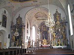
Rennertshofen, the baroque interior of the parish church

Church and rectory in Bertoldsheim
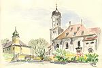
Stepperg, castle and church. Watercolor by Siegfried Schieweck-Mauk, Eichstätt

Stepperg Castle, middle wing

Castle ruins in Hütting
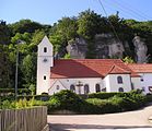
Hütting Church

Hütting, baroque church furnishings


Personalities
Sons and Daughters of the Market
- Maximilian von Arco-Zinneberg , known as the "Adlergraf" (1811–1885), lord of the castle von Zinneberg , born in Stepperg
- Johannes Leo von Mergel (1847–1932), Bishop of Eichstätt , born in Rohrbach
- Peter Bircks (1952–2018), an official at FC Augsburg, comes from the town and started his football involvement here.
- Manfred Heckl (1930–1996), university professor at the Institute for Technical Acoustics at the TU Berlin, 1973–1995
Connected to the place
- Bernd Eichinger (1949–2011), film producer, screenwriter and film director, grew up in Rennertshofen.
- Peter von der Grün (* 1972), District Administrator of the Neuburg-Schrobenhausen district, lives in the Bertoldsheim district.
Web links
- Vineyard caves near walls
- Rennertshofen: Historical search for traces - The Young Palatinate in Bavaria (House of Bavarian History)
- Entry on the Rennertshofen coat of arms in the database of the House of Bavarian History
Individual evidence
- ↑ "Data 2" sheet, Statistical Report A1200C 202041 Population of the municipalities, districts and administrative districts 1st quarter 2020 (population based on the 2011 census) ( help ).
- ↑ Marktgemeinde Rennertshofen in the local database of the Bayerische Landesbibliothek Online . Bayerische Staatsbibliothek, accessed on September 12, 2019.
- ↑ Rennertshofen market - population data, population figures of the individual districts with main residence
- ↑ Kienberg receives Bavaria's largest wind turbine , donaukurier.de of March 11, 2008; Accessed May 18, 2010
- ^ Federal Statistical Office (ed.): Historical municipality directory for the Federal Republic of Germany. Name, border and key number changes in municipalities, counties and administrative districts from May 27, 1970 to December 31, 1982 . W. Kohlhammer, Stuttgart / Mainz 1983, ISBN 3-17-003263-1 , p. 601 .
- ^ Federal Statistical Office (ed.): Historical municipality directory for the Federal Republic of Germany. Name, border and key number changes in municipalities, counties and administrative districts from May 27, 1970 to December 31, 1982 . W. Kohlhammer, Stuttgart / Mainz 1983, ISBN 3-17-003263-1 , p. 602 .
Ammerfeld with Altstetten and Asbrunn | Bertoldsheim | Emskeim | Erlbach | Hatzenhofen | Hütting with Ellenbrunn , Feldmühle , Giglberg and Wolpertsau | Walls with Siglohe and Treidelheim | Rennertshofen with gall mill | Riedensheim with Dittenfeld | Rohrbach | Stepperg with Antoni Berg , hundreds Thaler mill and Sprößlmühle | Trugenhofen with Kienberg , Dünsberg and Störzelmühle