Marriage churches
| coat of arms | Germany map | |
|---|---|---|

|
Coordinates: 48 ° 38 ' N , 11 ° 6' E |
|
| Basic data | ||
| State : | Bavaria | |
| Administrative region : | Upper Bavaria | |
| County : | Neuburg-Schrobenhausen | |
| Height : | 415 m above sea level NHN | |
| Area : | 62.79 km 2 | |
| Residents: | 3822 (Dec. 31, 2019) | |
| Population density : | 61 inhabitants per km 2 | |
| Postal code : | 86676 | |
| Primaries : | 08435, 08253 | |
| License plate : | ND, SOB | |
| Community key : | 09 1 85 127 | |
| LOCODE : | DE ZNE | |
| Community structure: | 24 parts of the community | |
| Address of the municipal administration: |
Bräugarten 1 86676 Ehekirchen |
|
| Website : | ||
| Mayor : | Günter Gamisch ( Free Voters / DG Ehekirchen ) | |
| Location of the community Ehekirchen in the district of Neuburg-Schrobenhausen | ||
Ehekirchen is a municipality in the district of Neuburg-Schrobenhausen in Upper Bavaria . The place of the same name is also the capital.
geography
location
Ehekirchen is located in the Ingolstadt planning region , 13 km south of Neuburg an der Donau on the state road 2035 to Augsburg .
Community structure
There are 24 officially named parts of the municipality (the type of settlement is given in brackets ):
|
|
|
The community consists of the districts Ambach, Bonsal, Buch, Dinkelshausen, Ehekirchen, Fernmittenhausen, Haselbach, Hollenbach, Schöneberg, Walda, Seiboldsdorf and Weidorf.
Neighboring communities
- Burgheim , district of Neuburg-Schrobenhausen
- Esterholz (community-free area) , Donau-Ries district
- Königsmoos , district of Neuburg-Schrobenhausen
- Oberhausen , district of Neuburg-Schrobenhausen
- Pöttmes , Aichach-Friedberg district
- Rain , Donau-Ries district
history

Until the church is planted
The Kühbach Monastery, founded in 1011, was the landlord of the place from its foundation until the secularization . Ehekirchen had been the border town of the Duchy of Neuburg-Sulzbach and its court in Neuburg since 1505 ; since 1777 the area was part of the Electorate of Bavaria . In the course of the administrative reforms in Bavaria , today's municipality was created with the municipal edict of 1818 .
Incorporations
The incorporations and incorporations extended over a period of more than six years. They began on January 1, 1972 with the incorporation of Schöneberg and ended on May 1, 1978 with five incorporations.
| Former parish | date | annotation |
|---|---|---|
| At the river | 01/01/1978 | |
| Bonsal | 01/01/1975 | |
| book | 10/01/1973 | |
| Dinkelshausen | 05/01/1978 | Reclassification of 63 inhabitants (1970) to Königsmoos |
| Fernmittenhausen | 05/01/1978 | |
| Haselbach | 01/01/1976 | |
| Hollenbach | 05/01/1978 | Reclassification of 85 inhabitants (1970) to Königsmoos |
| Schöneberg | 01/01/1972 | |
| Seiboldsdorf | 05/01/1978 | |
| Walda | 01/01/1978 | Reclassification of 57 inhabitants (1970) to Königsmoos |
| Weidorf | 05/01/1978 |
Population development
Between 1988 and 2018 the municipality grew from 3,188 to 3,769 by 581 inhabitants or by 18.2%.
| Population development | ||||||||||||||
|---|---|---|---|---|---|---|---|---|---|---|---|---|---|---|
| year | 1961 | 1970 | 1987 | 1991 | 1995 | 2000 | 2005 | 2010 | 2015 | 2017 | ||||
| Residents | 2804 | 2906 | 3118 | 3281 | 3507 | 3593 | 3752 | 3697 | 3698 | 3715 | ||||
politics
Municipal council
The 2014 local elections resulted in this distribution of seats:
- CSU: 6 seats
- Free voters: 10 seats
In the local elections on March 15, 2020 , the following composition of the municipal council resulted in the term of office from May 2020 to April 2026:
- CSU : 7 seats
- Free voter village community Ehekirchen: 8 seats
- Ecological Democratic Party : 1 seat
mayor
Mayor is Günter Gamisch (Free Voters Village Community Ehekirchen) since 2008 ; He was re-elected in 2014 and 2020. His predecessors were Heinrich Schmalbach (1990 to 2008) and Franz Braun (until 1990); A street in Ehekirchen is dedicated to the latter.
tax income
The municipal tax revenue totaled 2518 T € in 2012, of which the trade tax revenue (net) amounted to 756 T €.
coat of arms
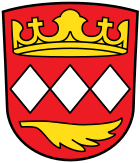
The coat of arms shows "three silver diamonds next to each other in red, above a golden crown, below a golden palm branch."
Churches
The Catholic parish community Ehekirchen comprises the parishes, branch churches and curatios of Ambach, Bonsal, Buch, Dinkelshausen, Ehekirchen, Fernmittenhausen, Haselbach, Hollenbach, Holzkirchen, Nähermittenhausen, Schainbach, Schöneberg, Seiboldsdorf, Walda and Weidorf.
Architectural monuments
Economy and Infrastructure
Economy including agriculture and forestry
According to official statistics, there were five employees at the place of work in 1998 in the field of agriculture and forestry, 404 in the manufacturing sector and 24 in trade and transport. In other economic areas, 97 people were employed at the place of work subject to social security contributions. There were a total of 1,100 employees at the place of residence subject to social security contributions. There were 14 companies in the manufacturing sector and six in the construction sector. In addition, in 1999 there were 211 farms with an agricultural area of 4270 hectares, of which 3106 hectares were arable land and 1159 hectares were permanent green space.
education
There are the following institutions (as of 2018):
- Day care centers for children: 2 with 164 places and 142 children
- Elementary schools: elementary and middle schools with a total of 275 pupils
literature
- Michael Leitenstern: The long way from the settlement at the swamp to the small center in Neuburger Kollektaneenblatt No. 126/1973, page 3–199. Neuburg on the Danube 1973.
Web links
- Local government
- Ehekirchen: Official statistics of the LfStat
- History of the main town on the parish homepage
Individual evidence
- ↑ "Data 2" sheet, Statistical Report A1200C 202041 Population of the municipalities, districts and administrative districts 1st quarter 2020 (population based on the 2011 census) ( help ).
- ↑ Municipal Council. Ehekirchen parish, accessed on June 14, 2020 .
- ^ Community Ehekirchen in the local database of the Bavarian State Library Online . Bayerische Staatsbibliothek, accessed on September 13, 2019.
- ↑ a b c d e f g h Federal Statistical Office (Hrsg.): Historical municipality directory for the Federal Republic of Germany. Name, border and key number changes in municipalities, counties and administrative districts from May 27, 1970 to December 31, 1982 . W. Kohlhammer, Stuttgart / Mainz 1983, ISBN 3-17-003263-1 , p. 601 .
- ↑ a b Federal Statistical Office (ed.): Historical municipality register for the Federal Republic of Germany. Name, border and key number changes in municipalities, counties and administrative districts from May 27, 1970 to December 31, 1982 . W. Kohlhammer, Stuttgart / Mainz 1983, ISBN 3-17-003263-1 , p. 602 .
- ^ Wilhelm Volkert (ed.): Handbook of Bavarian offices, communities and courts 1799–1980 . CH Beck, Munich 1983, ISBN 3-406-09669-7 , p. 522 .
- ↑ https://www.ehekirchen.de/rathaus/gemeinderat-2/
- ^ Entry on the coat of arms of Ehekirchen in the database of the House of Bavarian History


