Flüglinger Berg
| Flüglinger Berg | ||
|---|---|---|
|
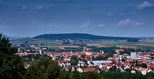
The Flüglinger Berg photographed from the Rohrberg . In the valley floor, Weißenburg in Bavaria and Weimersheim can be seen. |
||
| height | 541.3 m above sea level NN | |
| location | near Weimersheim , Weißenburg-Gunzenhausen district , Bavaria , Germany | |
| Mountains | Franconian Alb | |
| Coordinates | 49 ° 2 '38 " N , 10 ° 54' 16" E | |
|
|
||
| particularities | On the plateau there is a hill fort , an abandoned tower hill castle and three rectangular hills | |
|
Aerial view of the Flüglinger Berg from the south |
||
The Flüglinger Berg is 541 m above sea level. NN high mountain of the Franconian Alb low mountain range near Weimersheim , a district of Weißenburg in the district of Weißenburg-Gunzenhausen in Bavaria .
Geographical location
The Flüglinger Berg rises between Weißenburg and Alesheim in the Altmühltal Nature Park in the Weißenburger Alb , the western part of the Southern Franconian Alb . He is a witness mountain in the Franconian Keuper-Lias-Land . Weimersheim is to the east, and the district road WUG 1 is to the south . At the foot of the mountain are the sources of the Mittelbühlgraben and the Weimersheimer Bach .
Wall systems and tower hill castle
The plateau of the Flüglinger Berg was already climbed during the Mesolithic and settled from the Neolithic . It was also inhabited during the Hallstatt period and probably still in the Latène period . In the early Middle Ages , in the 7th to 10th centuries, there was a large central castle on the mountain plateau, it covered an area of 500 by 100 to 150 meters. A semicircular wall up to four meters high with an outer moat still testifies to it. During the High Middle Ages , probably in the 13th century, a tower hill castle was built on the east side of the plateau. The defunct castle still has an impressive tower hill, its surface is 55 by 60 meters, making it one of the largest and best preserved structures in the entire district. The complex was called Burg Flüglingen and was built by the Kropfen von Emetzheim, who then called themselves "von Flüglingen" after them.
During modern times the mountain was climbed again. At that time, three rectangular entrenchments were built, measuring around 50 × 60 meters, but their purpose is unknown. A maximum of three sides of the unfinished ski jumps have been preserved, the fourth side is formed by the southern steep slope. Only a part of the west side of the third, western ski jump has been preserved or completed.
literature
- Ingrid Burger-Segl, Walter E. Keller: Archaeological Hikes, Volume 3: Middle Altmühltal and Franconian Lake District . Verlag Walter E. Keller, Treuchtlingen 1993, ISBN 3-924828-58-X , pp. 52-55.
- Fritz-Rudolf Herrmann: Weimersheim, City of Weißenburg: ramparts and castle stables . In: Konrad Spindler (edit.): Guide to archaeological monuments in Germany, Volume 15: Weissenburg-Gunzenhausen district - monuments and sites . Konrad Theiss Verlag , Stuttgart 1987, ISBN 3-8062-0504-3 , pp. 201-202.
Individual evidence
- ↑ According to the Bfn card
- ^ Fritz-Rudolf Herrmann: Weimersheim, City of Weißenburg: Wall installation and castle stable . In: Konrad Spindler (edit.): Guide to archaeological monuments in Germany, Volume 15: Landkreis Weißenburg-Gunzenhausen - Monuments and sites , p. 201 f.


