Edersfeld
|
Edersfeld
City of Gunzenhausen
Coordinates: 49 ° 5 ′ 32 " N , 10 ° 43 ′ 36" E
|
||
|---|---|---|
| Height : | 437 (433-445) m | |
| Residents : | 53 (1966) | |
| Postal code : | 91710 | |
| Area code : | 09831 | |
|
Location of Edersfeld in Bavaria |
||
|
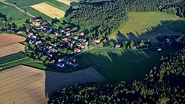
Edersfeld, aerial photo (2016)
|
||
Edersfeld is a district of Gunzenhausen in the central Franconian district of Weißenburg-Gunzenhausen . The place is located at an altitude of 437 meters above sea level.
Location and traffic
The "idyllic hamlet" is located southwest of Gunzenhausen, west of the Gunzenhausen district of Aha , with which it is connected by a road, east of federal highway 466 and west of district road WUG 28 . The Merzelfeldgraben flows through Edersfeld east of the Wurmbacher Berg . Gunzenhausen is around three kilometers (as the crow flies) away. The Altmühltal-Panoramaweg passes east of Edersfeld .
history
The place name means "To the field of an Ed (e) ram" or "Field of the Eder". The place was first mentioned in 1294 when Konrad von Lellenfeld , called Vrbuzze, serf of the Counts of Truhendingen entered the Auhausen monastery and transferred his property, including an estate in "Edramsuelt", to the monastery. It was not until the end of the 14th century that the place appeared again in a document: around 1370 , contributions to the Spielberg office of the Counts of Oettingen , who held the bailiwick , went from a fief to "Edersfelt", which belonged to the Benedictine monastery in Heidenheim . The Ellwangen Monastery also owned Edersfeld at this time.
In the 15th century, a St. Leonhard's Chapel was named to Edersfeld, which the city of Gunzenhausen bought from the Augustinian Canons Rebdorf in 1414 ; the "Linhardskapelle", a pilgrimage chapel, was gradually demolished after the Reformation until 1677, after the "chapel house", probably the clergyman's apartment, had already been sold in 1588. Furthermore, the monasteries Heidenheim and Ellwangen were wealthy in Edersfeld; The Teutonic Order branch in Ellingen also owned land there. A fish pond belonging to Schloss Spielberg was mentioned in 1436; it was temporarily owned by the Marshals von Pappenheim until 1493 ; In 1775 the Counts of Oettingen owned a "Weyherlein" there. In the 16th century, a subject of "Egersfelt" paid interest to the Carmelite monastery in Weißenburg . Charges also went to the Ansbachisch-margravial office of forest ; In 1532, "Edersfellt" was subject to the high court of the Margravial Oberamt Gunzenhausen. The margraves increased their property in the village in 1539, 1589 and 1590 through purchases.
At the beginning of the 17th century (1608) the ownership structure in "Odersveldt" was as follows: nine subjects were valid and vogtable to different margravial offices, one subject belonged to the fox of Bimbach zu Schwaningen . The Teutonic Order in Ellingen was also named as the landlord in 1667. In 1732 his yard was deserted; At that time Edersfeld was parish in the Protestant Aha since 1528, but the big tithe was largely due to the Augustinian monastery of Rebdorf. Local authority, the bailiwick and the high level of jurisdiction were still exercised by the Margravial Oberamt Gunzenhausen. At the end of the 18th century, eleven subjects were margravial and thus Prussian since 1792 and one subject was "foreign master", that is, belonging to the Teutonic Order in Ellingen.
In 1806 the Prussian rule ended, the village became Bavarian and belonged to the tax district Aha in the district court / rent office Gunzenhausen, later the district of Gunzenhausen . In 1811 the tax district was transformed into a rural community . In 1824 Edersfeld consisted of 15 properties with 95 inhabitants, in 1846 of 16 houses and 25 families with 87 people. In 1867 a local lexicon of the Kingdom of Bavaria reported 25 buildings and 78 inhabitants for the place.
In 1950 there were 81 residents in the 15 properties in the village; in 1966 there were 53. On May 1, 1978, the community of Aha, to which Edersfeld belonged, was incorporated into Gunzenhausen.
literature
- Johann Kaspar Bundschuh : Geographical statistical-topographical lexicon of Franconia . tape 3 . Stettinische Buchhandlung, Ulm 1801, DNB 790364301 , Sp. 692 .
- J. Heyberger and others (arr.): Topographical-statistical manual of the Kingdom of Bavaria with an alphabetical local dictionary. Munich 1867, column 1034.
- Robert Maurer: The Edersfeld Chapel; in: Gunzenhauser Heimatbote VI (1938–44), p. 150f.
- Historical Atlas of Bavaria. Francs . Row I, Issue 8: Gunzenhausen-Weißenburg . Edited by Hanns Hubert Hofmann. Munich 1960.
- Gunzenhausen district. Munich, Assling 1966, especially p. 188f.
- Edersfeld, Gde. Aha. In: Robert Schuh: Gunzenhausen. Former district of Gunzenhausen . Series of Historical Place Name Book of Bavaria. Middle Franconia, Vol. 5: Gunzenhausen . Munich: Commission for bayer. Landesgeschichte 1979, p. 67f.
- Home book of the city of Gunzenhausen, Gunzenhausen 1982, p. 246f.


