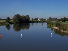
Altmühl feeder


The Altmühlzuleiter is an approximately 4.7 kilometers long, artificial watercourse that was created in the 1970s , with which the Altmühl water is taken during floods near the village of Gern near Ornbau in the district of Ansbach and the Altmühlsee near Streudorf near Gunzenhausen in the district of Weißenburg- Gunzenhausen is fed. The feeder is usually a good 50 meters wide and around two meters deep. Altmühlzuleiter, Altmühlsee and Altmühlüberleiter serve the Danube-Main crossing .
When the water level is normal, the water from the Altmühl does not flow through the Altmühlsee, but instead is diverted to the north and east of a river bed that was newly created when the lake was built. The Altmühlzuleiter forms the southern boundary of the Wiesmet .
Individual evidence
- ↑ a b Measured on the BayernAtlas of the Bavarian State Government ( notes )
- ↑ erwins-gedanken.de: The Altmühlsee ( Memento from September 15, 2014 in the Internet Archive )
Web links
- Course of the Altmühl supply line to: BayernAtlas of the Bavarian State Government ( information )
- Info about the Altmühl supply line
Coordinates: 49 ° 10 ′ 14.7 ″ N , 10 ° 39 ′ 8.1 ″ E