
The Lakeland
| The Lakeland | |
|---|---|
 Hiking trail sign |
|
| map | |

|
|
| Data | |
| length | 146 km |
| location | Bavaria |
| Starting point |
Petersgmünd 49 ° 11 ′ 7 ″ N , 11 ° 1 ′ 28 ″ E |
| Target point | Petersgmünd 49 ° 11 ′ 7 ″ N , 11 ° 1 ′ 28 ″ E |
The Lakeland is a 150 km long circular hiking trail in the Franconian Lake District in Middle Franconia ( Bavaria ).
location
The path extends over the districts of Weißenburg-Gunzenhausen , Ansbach and Roth . It connects the lakes of the Franconian Lake District, Altmühlsee , Großer Brombachsee , Kleiner Brombachsee , Igelsbachsee and Rothsee . In addition, it leads through the characteristic landscapes of the area, the Mönchswald , the hop gardens of the Spalter hill country with orchards , fields and species-rich nature reserves , past cities with historical flair, museums and Franconian beer gardens .
course
Most of the time, the route is on its own route, away from roads, and sometimes on paths. It is divided into eleven stages:
- Petersgmünd - Eckersmühlen
- Eckersmühlen - Fuchsmühle
- Fuchsmühle - Altenheideck
- Altenheideck - Pleinfeld
- Pleinfeld - Langlau
- Langlau - Schlungenhof
- Schlungenhof - Ornbau
- Ornbau - Muhr am See
- Muhr am See - Graefensteinberg
- Graefensteinberg - gap
- Spalt - Petersgmünd
Worth seeing
- The Rothsee with the nature reserve north-west bank of the Rothsee main barrier
- The Wernsbach quarries
- The Schnittlinger Hole
- The Altmühlsee
- The Brombachsee with the nature reserve peninsula in Kleiner Brombachsee and Grafenmühle
photos

Rothsee in winter
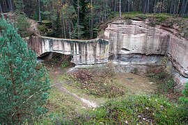
Wernsbach quarry
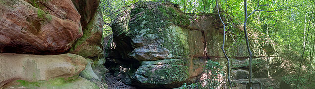
Schnittlinger Hole
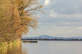
Brombachsee


.jpg)
