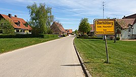
Oberhöhberg
|
Oberhöhberg
Haundorf municipality
Coordinates: 49 ° 11 ′ 35 " N , 10 ° 47 ′ 30" E
|
|
|---|---|
| Height : | 530 m |
| Residents : | 50 |
| Postal code : | 91729 |
| Area code : | 09837 |
|
Entrance
|
|
Oberhöhberg is a district of the Haundorf municipality in the Weissenburg-Gunzenhausen district of Middle Franconia in Bavaria . The hamlet has about 50 inhabitants and is located at an altitude of 530 m above sea level.
The place is located on the Höhberg , a ridge of the Spalter hill country in the middle of the Haundorfer Forest , which together with the Mönchswald forms a recreational area. The place is a state-approved resort . It is located near the road between Haundorf and Mitteleschenbach and is around 3 km away from both. The hamlet of Unterhöhberg is almost 700 meters to the east . There was probably a castle stable near Oberhöhberg . The northernmost point of the Weißenburg-Gunzenhausen district is located near Oberhöhberg, near the mountain top of the Hinterer Mönchsberg .
In the books of the Spalter Canon Monastery of St. Nikolaus from 1517 and 1549, one property is listed for Oberhöhberg that was subordinate to it.
Individual evidence
- ↑ According to the contour image in BayernViewer ( memento of the original from April 8, 2015 in the Internet Archive ) Info: The archive link was inserted automatically and has not yet been checked. Please check the original and archive link according to the instructions and then remove this notice. interpolated.
- ↑ own measurement with BayernViewer
- ↑ Friedrich Eigler : Schwabach (= Historical Atlas of Bavaria, Part Franconia . I, 28). Michael Laßleben, Kallmünz 1990, ISBN 3-7696-9941-6 , p. 113 f .

