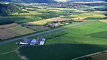
Rothenburg ob der Tauber airfield
| Rothenburg ob der Tauber airfield | ||
|---|---|---|
|
|
||
| Characteristics | ||
| ICAO code | EDFR | |
| Coordinates | ||
| Height above MSL | 399 m (1309 ft ) | |
| Transport links | ||
| Distance from the city center | 3 km east of Rothenburg ob der Tauber | |
| Street |
|
|
| Basic data | ||
| opening | 1957 | |
| operator | Aeroclub Rothenburg o. T. eV | |
| Start-and runway | ||
| 03/21 | 950 m × 70 m grass runway with asphalt strips 20 m | |
The Rothenburg ob der Tauber airfield is a commercial airfield near the Middle Franconian town of Rothenburg ob der Tauber . It is operated by the Aero-Club Rothenburg odTe V.
geography
The airfield is located about three kilometers east of the historic town center of Rothenburg ob der Tauber in the Langheckenfeld parcel at an altitude of 399 m above sea level. NN . Immediately to the west is the Lindleinsee nature reserve and the Central Franconian railway line .
In terms of nature, the terrain descends north to the Windsheimer Bucht , east and south it rises to the Frankenhöhe . The state border with Baden-Württemberg runs to the west .
history
The Aero-Club Rothenburg od Te V. , founded after the flight ban was lifted in 1949, began flying in 1952, initially at Burgstall . From 1957, the current site was used, which was expanded into an airfield in 1960/62. In the 1960s two hangars and a workshop were built. In 1972/73 the runway was initially paved over a length of 450 m, extended to 600 m in 1975 and the tower was built in 1976 .
In 1980 the airport was granted customs and passport clearance. In 1991/92 the asphalt runway was extended to 800 m and in 2003 to almost 1000 m.
Airfield and equipment
The airfield is approved for all types of aircraft up to 5700 kg maximum take-off weight (MTOW) and is usually in operation from 10:00 until sunset. The holder and operator of the airfield is the Aero-Club Rothenburg ob der Tauber. The place carries the ICAO code EDFR.
There are several farm buildings , a tower (frequency 126.360 MHz), six hangars and a restaurant. There is a gas station with JetA1 and AVGAS
Incidents
- On June 19, 1961, a German Air Force starfighter crashed northeast of Rothenburg od T., the pilot of which died.
- On January 25, 1962, the pilot was also killed in the crash of a Fiat G.91 R.3 fighter aircraft (registration number EC + 106 ).
- On April 17, 1974, the club plane Piper Colt (D-EFQO) flew into a forest in a snow storm near Füssen.
- On July 14, 1974, the club's Piper PA-28 D-EKKV aircraft crashed over the Swabian Alb near Geislingen an der Steige after a wing break .
- On July 22, 1981, a twin-engine Piper PA-34 Seneca (D-GABB) crashed during a test flight due to operating errors and caught fire. Four of the five occupants were killed, one survived the accident injured.
- On August 2, 2011, a TL-2000 Sting (D-MJGG) microlight aircraft crashed into a nearby corn field near Endsee, which cost the pilot and his instructor their lives despite the rescue parachutes.
traffic
A municipal road opens up the airfield to the state road St 2250 , which connects to the federal motorway 7 , which runs immediately to the west . The public transport do not operate the airfield directly, but there is a bike rental. In the village itself there is an option to board the Central Franconian Railway at Rothenburg ob der Tauber station .
Web links
- Rothenburg ob der Tauber airfield
- EDFR at oberpfalz-luftbild.de
- Airfield information for pilots
- Video, launch of EDFR; Flight to EDFC (YouTube video 51:18)
- Aviation map for Rothenburg ob der Tauber Airport on SkyVector.com
Individual evidence
- ↑ EDFR at BayernAtlas
- ↑ a b c Chronicle EDFR
- ^ Chronicle of the fire brigade Rothenburg od T.
- ^ Obituary Jürgen Ave
- ↑ Accident report PA-22 Colt D-EFQO , Aviation Safety Network WikiBase , accessed on August 28, 2020.
- ^ Accident report PA-28 Cherokee D-EKKV , Aviation Safety Network WikiBase (English), accessed on August 28, 2020.
- ^ Accident report PA-34 Seneca D-GABB , Aviation Safety Network WikiBase (English), accessed on August 28, 2020.
- ^ Press report Nordbayern.de from August 2, 2011
- ^ Accident report TL-2000 Sting D-MJGG , Aviation Safety Network WikiBase (English), accessed on August 28, 2020.

