
Schwandorf airfield
| Schwandorf airfield | |||
|---|---|---|---|
|
|||
| Characteristics | |||
| ICAO code | EDPF | ||
| Coordinates | |||
| Height above MSL | 387 m (1270 ft ) | ||
| Transport links | |||
| Distance from the city center | 6 km from Schwandorf | ||
| Street |
|
||
| Basic data | |||
| opening | 1960 | ||
| operator | City of Schwandorf | ||
| Start-and runway | |||
| 11/29 | 840 m × 30 m grass | ||


The Schwandorf airfield is a special airfield in the Upper Palatinate district of Schwandorf . It is owned by the city of Schwandorf and is run by Flugsportclub Schwandorf e. V. operated.
geography
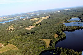
The airfield is located six kilometers east of the historic center of Schwandorf and three kilometers north of Wackersdorf at an altitude of 384 to 391 m above sea level. NN . In terms of nature, it is located in the Upper Palatinate Lake District north of the Steinbergersee, southwest of the Murnersee and west of the Brückl and Ausee. To the east the area rises to the Upper Palatinate Forest , south to the Bodenwöhrer Bucht and to the west the Naab valley extends . The state border with the Czech Republic runs 35 km to the east .
history
The Schwandorf airfield served as an operational airfield in the last months of the Second World War. The Bf 109 fighters manufactured by Messerschmitt were stationed there. From 1945, the Germans were initially banned from flying by the Allied occupying forces . After the flight ban was lifted in 1952, gliders were allowed to take off again. However, the space could initially no longer be used for takeoffs because it had been partially reforested. In 1959/60 the former military airfield was cleared. Regular flight operations have been taking place again since 1960.
Airfield and equipment
The airfield is a special landing site for aircraft of all types up to 2000 kg maximum take-off weight (MTOW), helicopters up to 3000 kg and has no regular operating times. Flight operations are every weekend and on public holidays from 9:00 a.m. to sunset, provided weather conditions permit. Landing is only possible after prior registration ( PPR ). The place carries the ICAO code EDPF.
There is a multi-purpose building with a ground-level flight control center (frequency 121.205 MHz), hangar and clubhouse as well as a winch launch facility . The traffic pattern is north of the course at 2200 ft.
The grass runway has a length of 840 m, width of 30 m and a drainage .
Incidents
- On May 2, 2003, a Forney 415D aircraft did not take off from EDPF in time and grazed treetops. The aircraft crashed and was destroyed, seriously injuring the pilot.
traffic
- The airfield is connected to the federal highway 85 and the federal highway 93 via the district roads SAD 9 and SAD 19 .
- The public transport does not serve the airport directly. In Schwandorf there are boarding options for several train lines and in Wackersdorf for bus lines 105 and 106.
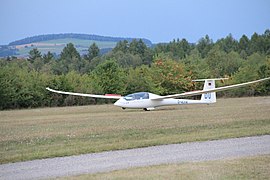
Schwandorf Airfield (2012)

(2012)
Schwandorf Airfield (2013)

Airfield Festival (2014)

Airfield Festival (2016)

Airfield Festival (2016)


Web links
- Flugsport-Club Schwandorf eV
- Aerial photos from the Schwandorf district
- Airfield information for pilots
- Flight operations on EDPF (YouTube video 11:37)
- Aviation map for Schwandorf Airfield on SkyVector.com
Individual evidence
- ↑ EDPF at BayernAtlas
- ↑ EDPF at Oberpfalz-Luftbild.de
- ↑ BFU Bulletin May 2003, Investigation Report 3X059-0 / 03 (.pdf)