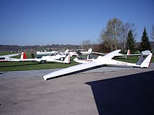
Schwabmünchen airfield
| Schwabmünchen airfield | ||
|---|---|---|
|
|
||
| Characteristics | ||
| ICAO code | EDNS | |
| Coordinates | ||
| Height above MSL | 550 m (1804 ft ) | |
| Transport links | ||
| Distance from the city center | 4 km west of Schwabmünchen | |
| Street |
|
|
| Basic data | ||
| opening | 1970 | |
| operator | Air sports club Schwabmünchen | |
| Start-and runway | ||
| 08/26 | 850 m × 30 m grass runway | |
The airfield Schwabmünchen is an airfield in the area of the city Schwabmünchen in the district of Augsburg . It is owned by the city of Schwabmünchen and is run by the Schwabmünchen e. V. operated.
location
The airfield is located about four kilometers west of the historic city center of Schwabmünchen in the Breitwiesen parcel at an altitude of 550 m above sea level. NHN in the Wertach valley .
In terms of nature, the Lechfeld extends to the east , to the west the terrain rises towards the perennials .
history
Aviation has been in operation in Schwabmünchen since the 1930s. From 1945, the Germans were initially banned from flying by the Allied occupying forces . The Luftsportverein Schwabmünchen eV, which was re-established after the flight ban was lifted in 1952 . V. started flying in the 1950s, initially between Schwabmünchen and Untermeitingen . From 1969, the current site was moved into, leveled, expanded and in 1970 was approved as a special airfield. The aircraft hangar, workshop and tower were built in 1972. It has had its own tow plane since 2012.
Airfield and equipment
The airfield is a special landing site for aircraft of all types up to 2000 kg MTOW , helicopters up to 5700 kg and mostly in operation from 7:00 am / 8:00 am until sunset. The holder of the airfield is the city of Schwabmünchen, the operator of the Luftsportverein Schwabmünchen e. V. Landing is only possible after prior notification ( PPR ). The place carries the ICAO code EDNS.
There are several farm buildings, a tower (frequency 122.500 MHz), a hangar, a winch launch facility and a club house. There is a petrol station for stopovers.
Events
Since 2012, the glider fair, a trade fair for model aircraft - gliders, motor gliders, retractable engines and accessories, has taken place every year in July.
Incidents
- On July 20, 1996, a Grob G 115 T Acro aircraft had an accident .
- On October 1, 2000, a Robin DR400 / 180 ( D-ENGR ) tipped sideways during take-off and fell into a field behind the end of the runway. The pilot was seriously injured and the aircraft was destroyed.
- On May 3, 2008 Schwabmunchen collapsed biplane of the type B & F FK 12 ( D MOUT ) from. The microlight caught fire and both occupants died.
traffic
A municipal road connects the airfield to state road St 2035 , which connects to federal road 17, which runs ten kilometers to the east . The public transport does not serve the airport directly. In Schwabmünchen there is an option to board the Lechtalbahn .
Web links
- Schwabmünchen airfield
- EDNS at oberpfalz-luftbild.de
- Airfield information for pilots
- Video, landing on EDNS; (YouTube video 1:37)
- Aviation map for Schwabmünchen airfield on SkyVector.com
Individual evidence
- ↑ View of the airfield in the BayernAtlas
- ↑ a b EDNS Chronicle
- ^ Review of the 2012 Glider Show. Accessed January 5, 2019 .
- ↑ BFU note from 1999 (.pdf)
- ↑ BFU report October 2000 (.pdf)
- ↑ Press report May 2008
- ^ Accident report B&F FK 12 D-MOUT , Aviation Safety Network WikiBase (English), accessed on December 18, 2017.

