
Nau
| Nau | ||
.JPG) The Nau east of Langenau |
||
| Data | ||
| Water code | DE : 11592 | |
| location |
Swabian Alb
|
|
| River system | Danube | |
| Drain over | Danube → Black Sea | |
| source | northwest of Langenau 48 ° 29 ′ 54 ″ N , 10 ° 6 ′ 18 ″ E |
|
| Source height | 461.7 m above sea level NN | |
| Spring discharge |
MQ |
230 l / s |
| muzzle | opposite Günzburg in the Danube Coordinates: 48 ° 27 '49 " N , 10 ° 16' 36" E 48 ° 27 '49 " N , 10 ° 16' 36" E |
|
| Mouth height | 440 m above sea level NN | |
| Height difference | 21.7 m | |
| Bottom slope | 1 ‰ | |
| length | 21.1 km | |
| Catchment area | 104.33 km² | |
| Small towns | Langenau , Günzburg | |
| Communities | Leipheim | |
The Nau is a 21.1 km long left tributary of the Danube in Baden-Württemberg and Bavaria . Its two source rivers, the Warm and the Cold Ach, arise from several karst springs in Langenau . East of the city they unite to form the Nau. The Warm Ach is considered to be the main source river. The Nau flows through parts of the Donauried and flows into the Danube at Günzburg .
Surname
The name Nau goes back to the Indo-European root nau , for valley, channel or river. The river gave the city of Langenau its name.
geography
Source rivers

Warm ah
The Warm Ach (also called Nau here ) is the main source river of the Nau, about 3 km long. It rises from the Nau origin on the western edge of Langenau. Less than a hundred meters after the source, the Rohngraben flows from the west , the direction of which it assumes. At the former Öchslesmühle it is reinforced by other sources. Then the Warm Ach crosses the city from west to east. The Flötzbach, which flows down from Hörvelsingen from the west-south-west and is over 8 km long, flows into the urban area about one kilometer down from the Nau origin . After the Bahnhofstrasse, the warm Ach is divided up. The river island bears the name Wörth . The city park of the same name is located on it . The left arm resulting from the division carries significantly less water. It is fed to the Kalten Ach , which rises a little north of the left bank , shortly after its source. The right arm of the river only approaches again at the summit of the Kalten Ach . From there, both source rivers run parallel for about 700 m and unite at the Ostener Kuften to the Nau (Lage) .
Nau origin

The origin of the Nau is in the northwest of Langenau, right next to a hiking home. It is a karst spring that pours an average of around 230 liters per second. The source is in a former quarry , but nothing can be seen today. The hollow is now completely filled with spring water. Much of the water in the spring comes from the Lone , which partially seeps into the subsoil near Bernstadt and reappears in the Nau origin and in some neighboring springs. The Nau flows from the origin of the Nau, which is also called the Warm Achs there.
Cold Oh

The approximately 1.4 km long Kalte Ach is the left, shorter source river of the Nau. It rises from the karst springs of Baders Weiher , also called Bunzenmüllersweiher , and the spoon fountain in Langenau. Shortly after the Baders Weiher , a small part of the arm of the Warm Ach that runs south is fed to it. This spring branch joins the one from the spoon fountain on Wörthstrasse . Until 1960, the water from this spring was fed into Langenau's drinking water supply . The so-called "Pumphäusle" standing there reminds of this historical time. A little further east, the Kalte Ach is reinforced by the Kalmenbrunnen .
course
After the confluence of the source rivers, the Nau flows south. It runs through the Donauried and unites with the Schammenbach just before the Sixenmühle . From there the Nau flows further to the southeast, crosses the state border to Bavaria and reaches the town of Riedheim . On the eastern edge of the village you open the Schwarzgraben from the left . It rises east of Langenau from the karst spring funnel Grimmensee . The Nau continues east into the Günzburger Donauwald, where it finally flows into the Danube opposite the Günz estuary .
Tributaries


-
left tributary
- Cold Oh
- Simontalgraben
- Schwarzgraben
- Cold Oh
-
right tributary
- Rohngraben
- Flötzbach
- Schammenbach
- Weiherbach
- Sulzbach
- Deißenbach
history
The area has been populated since the Neolithic Age. Around the 4th century, the first settlements were the Alemanni at the Nau. The many mills on the Nau were built for linen weaving and for grinding grain. During the 18th century, the areas around the Nau were used as pastures, for litter extraction and for peat extraction. Today there are fields with crops in addition to the young cattle pastures. The peat extraction was stopped.
Mills on the Nau

There are some old mills on the Nau, some of which are also listed:
- Upper mill
- Öchslesmühle
- Long mill
- Bunzenmühle
- Farmer's mill
- Urism mill
- Beinesenmühle
- Easter mill
- Mussism mill
- Sixenmühle
- Sea mill
The only still active watermill is the Easter mill, which specializes in spelled products.
Picture gallery
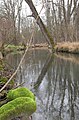
The Nau near Leipheim

Beaver tracks on the banks of the Nau
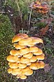
Mushrooms on the banks of the Nau


literature
- Schwäbischer Albverein, local group Langenau: The Jubiläumsweg
Web links
Individual evidence
- ^ Hans Graul : Geographical land survey: The natural space units on sheet 179 Ulm. Federal Institute for Regional Studies, Bad Godesberg 1952. → Online map (PDF; 4.8 MB)
- ↑ State Institute for the Environment Baden-Württemberg (LUBW) ( information )
- ↑ a b Directory of the brook and river areas in Bavaria - Danube river area from source to Lech, page 30 of the Bavarian State Office for the Environment, as of 2016 (PDF; 2.3 MB)
- ↑ Data from a limited measurement period during an intensive measurement program. The mean value calculated from this is not representative and does not reflect the long-term hydrological conditions.
- ↑ Information board in Langenau: Mühlen an der Nau