Kilijaarm
|
Kilijaarm (Chiliaarm) |
||
| Data | ||
| location | Romania / Ukraine border | |
| River system | Danube | |
| Junction | from the Danube on Ukrainian and Romanian territory north of Tulcea 45 ° 13 ′ 44 ″ N , 28 ° 44 ′ 10 ″ E |
|
| muzzle | into the Black Sea Coordinates: 45 ° 13 ′ 18 ″ N , 29 ° 44 ′ 31 ″ E 45 ° 13 ′ 18 ″ N , 29 ° 44 ′ 31 ″ E
|
|
| Medium-sized cities | Tulcea | |
| Small towns | Wylkowe | |
| Communities | Palazu, Pardina, Chilia Veche, Periprava. | |
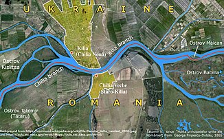
The Kilijaarm (also Chiliaarm , Ukrainian Кілійське гирло / Romanian Brațul Chilia ) is the northernmost estuary of the Danube into the Black Sea . Together with the other two estuary arms, the Sulina arm and the Sfântu-Gheorghe arm , they form the Danube Delta .
description
The Kilijaarm is the estuary with the most water (60 percent of the total amount of water flows over the Kilijaarm into the Black Sea). It is the most widely used arm of the Danube for shipping. It is 116 km long, has its own kilometers and forms the border between Romania (right bank) and Ukraine (left bank). The last kilometers of the Kilijaarm are in Ukraine on both sides. It is named after the Ukrainian city of Kilija .
On the left bank of the Kilijaarm are the important Ukrainian ports of Ismajil (km 90), Kilija (km 47) and Wylkowe (km 19).
See also
literature
- Petre Gâștescu, Romulus Știucă: Delta Dunării - Rezervaţie a biosferei. București 2008, ISBN 978-973-1760-98-9 , p. 398. (Romanian)
Web links
- Danube Biosphere Nature Reserve ( Memento from April 24, 2015 in the Internet Archive ) Дунайский биосферный заповедник (Danube Delta Biosphere Reserve)
- romanianmonasteries.org , Delta Dunării

