
Straubing lock
| Straubing lock | ||
|---|---|---|
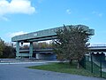
 Looking west |
||
| location | ||
|
||
| Coordinates | 48 ° 54 '0 " N , 12 ° 33' 15" E | |
| Country: | Germany | |
| Place: | Straubing | |
| Waters: | Old Danube | |
| Water kilometers : | km 2322.02 | |
| Data | ||
| Operator: | WSA Regensburg | |
| Responsible WSA : | WSA Regensburg | |
| Construction time: | 1989-1993 | |
| lock | ||
| Type: | Inland lock | |
| Is controlled by: | WSV control center Regensburg | |
| Usable length: | 230 m | |
| Usable width: | 24 m | |
| Height upstream : | 320 m above sea level NN | |
| Average height of fall : |
6.25 m | |
| Upper gate: | double-leaf mortise gate , 83 t each | |
| Lower gate: | double-leaf mortise gate, 83 t each | |
| Fill chamber; to empty: | 44000 m³; 20 min | |
| Others | ||
| Associated weir: | Straubing barrage 48 ° 53 ′ 50.64 ″ N , 12 ° 33 ′ 23.76 ″ E |
|
| Associated power plant: | Straubing run-of-river power plant | |

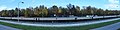
The Straubing lock was built with the overall construction measure of the Straubing barrage in 1993 for the continuity of navigation on the Danube .
Location and technical data
The chamber of the individual lock is located at Danube kilometer 2322.02, has a chamber length of 264 m, a usable length of 230 m and a usable width of 24 m. The chamber was built in concrete and is closed at the top and bottom by a two- wing mortise gate . Each miter gate weighs 83 t. The 14 meter high and 12 meter wide steel gates stand on a spherical bearing . The chamber is filled and emptied via circulation channels with two gates each on the top and bottom as a closure.
The chamber filling time is 20 minutes with a lock water volume of 44,000 m³. A lock takes 25 minutes. The lock holds 73,000 m³. The level of the upper edge of the lock platform is 321.5 m above sea level. NN , the level of the jamb of the underwater is 308.7 m above sea level. NN .
For maintenance and repair work on gates and locks, the lock has a gantry crane with a load capacity of 100 t , which can be moved over the entire length of the lock.
Fall height and water level
At the associated weir of the Straubings power plant, the expansion target is 320 m above sea level. NN , the water levels of the lock underwater are at mean water level at 313.75 m above sea level. NN and at regulatory low water level (RNW) at 312.32 m above sea level. NN . The corresponding sluice fall height is 6.25 meters for mean water and 7.68 meters for RNW. The height of fall of the lock is indicated as 6.21 m on an information board by the system.
control
The lock is remote-controlled from the WSV control center in Regensburg . The Geisling , Regensburg and Bad Abbach locks are also remotely controlled from this control center . Originally, the Straubing lock was served from the lock tower on site.
bridge
Immediately below the lower head, the Kager Bridge crosses the Alte Donau lock canal .
Missing route
The kilometering of the Danube in the Straubing lock shows a faulty stretch of 7.9 kilometers. That is why there are both kilometer markings 2330 and 2322 on the lock basin.
gallery

View from the upper water to the head
100t gantry crane

Lock tower no longer used
Markings of the missing section in the lock


Web links
- WSV's Danube Route Atlas, page 64 (PDF; 11.9 MB)
- Photo gallery of the dry chamber when changing gates ( memento from September 24, 2015 in the Internet Archive ) idowa; April 20, 2010
Individual evidence
- ↑ a b c d e f g h i j k l m Information board on the site of the barrage, viewed on October 13, 2013
- ↑ a b c Descent structures on federal waterways. (PDF; 44 kB) Federal Waterways and Shipping Administration , accessed on October 7, 2013 .
- ↑ Ulli Scharrer: 83-ton lock gate was installed in the Straubing barrage. (No longer available online.) Idowa, April 20, 2010, archived from the original on August 12, 2014 ; accessed on August 8, 2014 . Info: The archive link was inserted automatically and has not yet been checked. Please check the original and archive link according to the instructions and then remove this notice.
- ↑ a b Plan approval procedure for waterway expansion and flood protection Straubing - Deggendorf. (PDF; 0.6MB) Enclosure 33rd Federal Waterways and Shipping Administration , July 3, 2014, accessed on March 8, 2015 .
- ↑ Route atlas of the Danube from km 2414 (Kelheim) to km 2202 (Jochenstein). (PDF; 11.9 MB) (No longer available online.) Federal Waterways and Shipping Administration, p. 6 , archived from the original on February 8, 2015 ; Retrieved February 8, 2015 . Info: The archive link was inserted automatically and has not yet been checked. Please check the original and archive link according to the instructions and then remove this notice.
![]() Bad Abbach |
Regensburg |
Geisling |
Straubing |
Tile
Bad Abbach |
Regensburg |
Geisling |
Straubing |
Tile
![]() |
Jochenstein |
Aschach |
Ottensheim-Wilhering |
Winding branches |
Wallsee-Mitterkirchen |
Ybbs-Persenbeug |
Melk |
Altenwörth |
Greifenstein |
Nussdorf |
Freudenau |
Gabčíkovo |
Cunovo |
Iron Gate 1 |
Iron Gate 2
|
Jochenstein |
Aschach |
Ottensheim-Wilhering |
Winding branches |
Wallsee-Mitterkirchen |
Ybbs-Persenbeug |
Melk |
Altenwörth |
Greifenstein |
Nussdorf |
Freudenau |
Gabčíkovo |
Cunovo |
Iron Gate 1 |
Iron Gate 2![]()
![]()
![]()
![]()
![]()
![]()
![]()