Jantra
| Jantra | ||
|
Jantra (red line) - in Bulgaria |
||
| Data | ||
| location | northern Bulgaria | |
| River system | Danube | |
| Drain over | Danube → Black Sea | |
| source | in the Balkan Mountains on the north slope of the Hajim Dimitar summit | |
| Source height | 1340 m | |
| muzzle | at Iatrus Fort near Swishtow in the Danube Coordinates: 43 ° 38 ′ 27 " N , 25 ° 34 ′ 12" E 43 ° 38 ′ 27 " N , 25 ° 34 ′ 12" E
|
|
| length | 285 km | |
| Catchment area | 7862 km² | |
|
Bulgaria - River: Jantra |
||
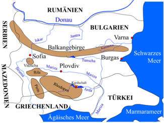
The Jantra (Bulgar. Янтра , Latin. Iatrus) is a tributary of the Danube in northern Bulgaria . It is 285 km long and drains an area of 7,862 km², making it the largest water catchment area in northern Bulgaria.
The source is located in the central Balkan Mountains ( Средна Стара планина ) on the northern slope of the summit Haji Dimitar ( Хаджи Димитър ) 1,340 m above sea level. d. On the upper reaches of the Jantra, it is often referred to by its old name Etar ( Етър ), after which an open-air museum is also named. At the headwaters, the bank is mainly lined with oaks .
At the foothills of the Balkan Mountains, the Jantra flows through several narrow gorges. The largest breakthrough - in the historic Bulgarian capital Veliko Tarnovo - has a length of 7 km. From here the river is navigable.
In ancient times the Jantra was called Athrys , Iatros (Latin Iatrus ) or Ieterus . It flows into the Danube at the former Roman fort Iatrus / Krivina near the town of Swishtow .
It is the third longest tributary of the Danube in Bulgaria (after Iskar and Ossam ).
The river has given its name to Yantra Cove , a bay on Livingston Island in Antarctica , since 2004 .
Major tributaries
- Rositsa ( Росица )
- Lefedscha ( Лефеджа )
- Julnitsa ( Julynitsa )
Cities on the Jantra
- Gabrovo ( Габрово )
- Veliko Tarnovo ( Велико Търново )
- Gorna Orjachowiza ( Горна Оряховица )
- Polski Trambesch ( Полски Тръмбеш )
- Bjala ( Бяла )

