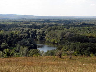
Siversky Donets
The Siwerskyj Donets ( Ukrainian Сі́верський Доне́ць , Russian Се́верский Доне́ц Severski Donez , mostly just called Donets ) is a right, 1053 km long tributary of the Don in southwest Russia and in eastern Ukraine ( Eastern Europe ).
The river , whose catchment area covers 98,900 km², was named after the Severian tribe (Russian Северя́не ).
Name of the river
The river has several "unofficial" names and designations: In Russian it is also called Little Don ( Ма́лый Дон ). Occasionally the linguistically and geographically incorrect German translation "Northern Donets" is used to delimit the river from the Don . But mostly the short form Donets is used.
course
The course of the Siversky Donets is 950 km in Ukraine. It rises around 100 km north of Belgorod and flows a little south of Ust-Donetski . The headwaters and estuaries are both in Russia.
The Siversky Donets arises in the south of the highlands of the Central Russian Plate, not far from the Kursk Oblast . In the course of Belgorod it has only a very slight gradient. Once in Ukraine, the river flows into the 86 km² Pechenihy reservoir , from which the city of Kharkiv draws drinking water . It then flows in an easterly direction north of the Donets Ridge past several Ukrainian cities, including Lysychansk and Sjewjerodonezk , before reaching Russian territory again and forming the Russian-Ukrainian border for a section of about 30 kilometers. As a so-called “steppe river” with mostly little water, the Siwerskyj Donets flows into the Don, which itself only pours 150 km further down the valley into the Sea of Azov .
Hydrology
The river mostly carries rain and melt water. It reaches its highest water level between February and April. On an annual average, 159 m³ / s of water flow off. Around 315 km of its course is navigable , but it is frozen over from December to mid-March.
Environment and tributaries
On the right (southern) bank of its central reaches is the Donets Basin , a large coal mining area and an important industrial area. Important tributaries are Oskol , Ajdar , Derkul and Kalitwa .
Web links
Individual evidence
- ↑ a b c Article Siwerskyj Donets in the Great Soviet Encyclopedia (BSE) , 3rd edition 1969–1978 (Russian)
- ↑ a b Siwerskyj Donets in the State Water Register of the Russian Federation (Russian)


