Apatin
|
Апатин Apatin |
||||
|
||||
| Basic data | ||||
|---|---|---|---|---|
| State : | Serbia | |||
| Province : | Vojvodina | |||
| Okrug : |
Zapadna Backa |
|||
| Coordinates : | 45 ° 40 ′ N , 18 ° 59 ′ E | |||
| Height : | 82 m. i. J. | |||
| Area : | 333 km² | |||
| Residents : | 17,352 (2011) | |||
| Population density : | 52 inhabitants per km² | |||
| Telephone code : | (+381) 025 | |||
| Postal code : | 25260 | |||
| License plate : | SO | |||
| Structure and administration | ||||
| Structure : | 5 districts | |||
| Mayor : | Živorad Smiljanić | |||
| Website : | ||||
Apatin ( Serbian - Cyrillic Апатин [ ˈapatin ] ) is a town on the Danube in the Zapadna Bačka district of the autonomous province of Vojvodina in Serbia with about 17,350 inhabitants. The administrative headquarters of Opština Apatin is about 120 km from Novi Sad . Apatin had a large shipyard and a Danube port, which the ships of the Danube Steamship Company used to call at.
history
The first mention of Apatin is from 1011 when it was an abbey of the Archdiocese of Kalocsa . The name Apatin may also be derived from the word abbey, see the Serbo-Croatian equivalent opatija , which denoted Roman Catholic, predominantly Benedictine, abbeys. At that time Apatin belonged to Hungary . Around 1417 it is counted among the Hungarian fiefdom of Stefan Lazarević . The Ottomans captured Apatin around 1541 and stayed until around 1689.
Habsburg monarchy
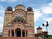
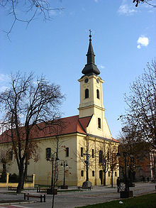
In the Great Turkish War , Apatin came to the Habsburg Monarchy around 1690 . The village was first repopulated by Serbian refugees south of the Danube and called Buksinovacz . In 1739, Apatin was founded on the site of the old Opati (or Opaty) predium as a so-called "Schüttkasten" (bridgehead with provisions station) by the Viennese court chamber at the former terminus of the Ulmer Schachteln and settled with German guards from nearby Esseg , while the Serbian residents were resettled to Stapar near Sombor . In 1748 the first Roman Catholic church ("Maria Himmelfahrt") was built, followed by the settlement of Danube Swabians . Apatin is an early Heresian camera settlement that was expanded in two phases. You can see them in the floor plan. The south-east belongs to the first phase of the founding from 1750 to 1753. This part is constructed more irregularly than the north, which offers the appearance of a geometric checkerboard shape. Your system is dated from 1764 to 1766. Although the overall impression lacks a consistent building template, the planned layout of the new architectural style is already clearly evident.
In general, the Austrians have already adopted existing geographical names. One must therefore assume that the place was already called Apatin. The form of the name Abthausen , a (probably wrong) translation by the German Wehrmacht , has therefore never been official since the German settlement on the Danube.
In 1820 Apatin already had 5,389 inhabitants, including 5,316 Germans. In 1881 there were 11,973 inhabitants in Apatin who operated silk spinning, hemp cultivation and fishing. Until 1944, Apatin was the largest German community in Yugoslavia with around 14,000 residents.
Apatin in World War II
After the First World War, Apatin was the spiritual center of German Catholicism in the newly formed Kingdom of Yugoslavia . The Roman Catholic weekly Die Donau, which became known far beyond the borders of the country and was banned by the Hungarian occupation authorities in 1941 at the instigation of Germany, has been published here since spring 1935 because of its stand against National Socialism . On March 11, 1945, the non-fled Apatin population was driven from their homes by the partisans and taken to the penal camps there in Gakovo and Kruševlje . After a few months, 700 Apatines died of starvation there. A total of 2074 Apatin victims are known by name among the civilian population; This also includes those who perished in the deportation of civilians from the Banat and Batschka to the Soviet Union carried out by the Tito regime in 1944/45 .
Apatin after World War II
With the expulsion of the German population, the ethnic structure of the place changed. The gaps in the settlement created by the exodus of the Danube Swabians were closed again by 6000 Serbian settlers (colonists) from the Lika region in Croatia. After the Yugoslav wars of 1991–1995, the population structure changed again in favor of the Serbs, as many (especially young) Hungarians fled to Hungary for fear of being recruited into the Yugoslav army , and since Apatin, like most other villages in Vojvodina, other Serbian refugees who recorded Krajina (Lika), but also from Bosnia and later from Kosovo .
After the Second World War , only a small part of the Danube Swabians returned to the city. In the 2012 census , 163 out of 17,411 people in the city of Apatin identified themselves as Germans (0.94% of the population), in Opština 182 out of 28,929 (0.63% of the population; 2002 figures: 142 or 0, 74% in the city, 159 or 0.48% in the Opština). That is the second highest value of the German minority in Serbia .
economy
The Apatinska Pivara ad Apatin brewery, founded in 1756 and whose main brand Jelen Pivo (“deer beer”) is the most popular beer in Serbia, is the largest employer in the area.
Donaumühlen
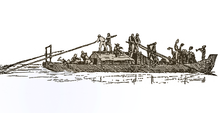
The Apatin Danube mills were known throughout the Batschka . These were ship mills that were built in the form of a catamaran . Main and secondary aisles were connected by a bridge. The water wheel was behind the bridge and was stored on both ships. In the main ship there were two grinders, the sieves and the bag filling systems. The grinders had steel rollers, in contrast to the stone grinders still common in Germany at that time. A direct current generator provided electrical light. The power transmission from the water wheel to the transmissions took place via large wooden gears. The grinders and the sieves were belt driven. The mills were anchored at a point on the Danube where the current was strongest. They were brought to the winter harbor in late autumn because the Danube froze over in winter. Farmers from all over the region brought their wheat to Apatin for grinding because the quality of the flour from the Danube mills was famous. The miller was paid in kind: he kept 10% toll from the finished products (flour, semolina, bran). The wheat and the grist were transported in a barge that was rowed by two journeyman millers and steered by the miller.
Around 1900 there were 64 Donaumühlen in Apatin. Many did not survive the competition from the steam mill. The last Danube mill was owned by the Apatin Danube Swabian Georg Kammerer (1889–1967). It was decommissioned in the 1950s.
Sports
The football club FK Mladost Apatin played for many years in the country's second division , including the Serbian SuperLiga in the 2006/07 season . Due to major financial problems, the association was dissolved in 2011. The OFK Mladost was founded in its place, but it was classified in the lowest league.
sons and daughters of the town
- Paul Abraham (* 1892, † 1960 in Hamburg), composer
- Robert Benz (* 1954), German pianist and music teacher
- Adam Berenz (* 1898, † 1968 in Kalocsa), Roman Catholic clergyman , journalist and resistance activist in the Batschka during the National Socialist era
- Anthony Bruck (* 1901, † 1979 in New York), university professor, writer and psychologist
- Nenad Medić (* 1983), professional Canadian poker player
- Josef Sayer (* 1941), German theologian and development worker
- Anton Schwob (* 1937), Austrian Germanist
- Ervin Šinko (* 1898, † 1967 in Zagreb), Hungarian writer and professor
- Lajos Szűcs (* 1943, † 2020), Hungarian football player and actor
Web links
- Website of the Opština Apatin (Serbian)
Individual evidence
- ↑ J. Weidlein, The so-called Römerschanzen in the Batschka. In: Südostforschungen, born in 1964.
- ↑ JV Senz: Apatiner Heimatbuch. Rise, achievement and decline of the Danube Swabian community of Abthausen / Apatin in the Batscher Land. Straubing 1966.
- ↑ see Peter Kottler 2007, p. 195
- ^ J. Eimann: Der Deutsche Kolonist , Pest 1822.
- ^ Meyers Lexikon, Volume 1, 1888.
- ↑ Попис становништва, домаћинстава и станова 2011. у Републици Србији. Становништво: Национална припадност (2012).
- ↑ Popis iz 2002. [Census 2002], Knjiga 1, Stanovništvo, nacionalna ili etnička pripadnost, podaci po naseljima, Republički zavod za statistiku , Beograd, February 2003, ISBN 86-84433-00-9 .
- ^ Biographical Sketch of Anthony Bruck (1901-1979) .


