
Liberty Bridge (Novi Sad)
Coordinates: 45 ° 14 '2 " N , 19 ° 50' 58" E
| Liberty Bridge | ||
|---|---|---|
 |
||
| Official name | Мост Слободе / Most Slobode | |
| use | Road and pedestrian bridge | |
| Crossing of | Danube | |
| place | Novi Sad | |
| construction | Cable-stayed bridge | |
| overall length | 1312 m | |
| width | 27.60 m | |
| opening | 1981/2005 | |
| location | ||
|
||

The Liberty Bridge ( Serbian : Мост Слободе / Most Slobode ) is a cable-stayed bridge over the Danube in Serbia's Novi Sad .
It was built between 1976 and 1981 and opened to traffic in 1981, on the anniversary of Novi Sad's liberation from the German occupiers. The people of Novi Sad also refer to the bridge as "Kamenički Most" because it leads to Sremska Kamenica . The bridge is a reinforced concrete structure, it is 1312 m long and 27.60 m wide. It has six vehicle and two pedestrian lanes, the two pylons are 60 m high. The bridge was designed by the architect Nikola Hajdin and executed by the Belgrade company Mostogradnja.
The bridge was destroyed on April 3, 1999 during a NATO air raid and has since been a major obstacle to shipping. On October 11, 2005, the rebuilt bridge was officially opened to traffic; the restoration took around two years and cost around 40 million euros .
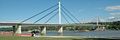
Liberty Bridge over the Danube in Novi Sad (August 2005)

Freedom Bridge destroyed by air raid (2001)

Rebuilding the bridge

