
Dobratsch
| Dobratsch Villacher Alpe |
||
|---|---|---|
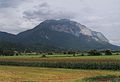
 South side of Dobratsch from Hohenthurn seen |
||
| height | 2166 m above sea level A. | |
| location | Carinthia , Austria | |
| Mountains | Gailtal Alps | |
| Dominance | 16 km → Visoka Ponca | |
| Notch height | 1233 m ↓ Bleiberger Tal | |
| Coordinates | 46 ° 36 '13 " N , 13 ° 40' 13" E | |
|
||
| rock | Reef limestone , Wetterstein limestone | |
| Age of the rock | Ladinium | |
| Development | Villach Alpine Road | |
| particularities |
Sender Dobratsch German and Windische Kapelle |
|

The Dobratsch or the Villacher Alpe ( Slovenian Dobrač or Beljaščica ) is a 2166 m above sea level. A. high mountain in Carinthia . It forms the eastern foothills of the Gailtal Alps and is located immediately west of the city of Villach . The Dobratsch area is protected as a nature park . The Dobratsch Nature Park extends over an area of around 8,200 hectares.
Location and landscape
The Dobratsch lies as the spur of the Drauzug (Gailtal Alps) above the confluence of the Drau and Gail .
West side of the Dobratsch seen from the Gailtal

Summit cross on the Dobratsch

View over Lower Carinthia


Boundary and structure
According to the Austrian mountain group classification according to Trimmel , the Villach Alps group bears the number 3740, as part of the Gailtal Alps (Trimmel 3700, AVE 56, also called Drauzug ) and is defined as follows:
- in the south Nötsch - Gail to the mouth (near Villach ) to the Karawanken
- in the north-east of the Drau up to Gummern to the Nock Mountains
- in the north and east: Weißenbach via Mittewald - Bad Bleiberg to Kreuth - Nötschbach to Nötsch to the Graslitzengruppe of the Gailtal Alps ( Schwandnock , Kowesnock )
The Dobratsch (number 3741) is actually delimited from the eastern foothills, the Pungart (number 3742), the dividing line runs (S-N):
- Gail west of Oberschütt - Wabenriedel - Fellachbach - Heiligengeist - Mittewald am Weißenbach
geology
The Dobratsch massif is part of the geological unit of the Drauzug . It is bounded on all sides by faults : in the south (Gailtal) by the Periadriatic Seam , in the north by a fault running along the Bleiberger valley. To the west, the rocks of the Dobratsch massif are presumably pushed tectonically onto the rocks of the Karbon von Nötsch . To the east, along faults running approximately north-south, the rocks are lowered in steps towards the Villach Basin and are finally cut off at an angle by the Drautal fault.
The Dobratsch massif consists of two superimposed ceilings: the Dobratsch summit floe and the Dobratsch base cover. As a result of the Dobratsch thrust, there is a repetition of layers from the Alpine Muschelkalk. The base layer consists of a sequence of layers that extends from the Val Gardena layers to the Raibl layers , the summit floe consists of alpine shell limestone, pied limestone and above all Wetterstein limestone , subordinate to the Raibler layers and main dolomite . The sedimentary rocks lie with a tectonic boundary on Gailtalkristallin.
The special importance of the Dobratsch massif is that the rocks of the Triassic (Mesozoic), especially the Middle Triassic, differ significantly from the rest of the Drauzug (Gailtal Alps), but show strong echoes of the southern Alpine Triassic Karawanken .

On the southern slope of the Dobratsch massif, especially in the Schütt area , the rocks up to the base of the wall are often covered by landslide material and debris. The solid rocks only come to light here and there, especially in the area of gullies and debris flows. In the valley area, the rockslide masses overlie the loose ice-age sediments of the Gail.
Dobratsch landslides
The Dobratsch Stock was the scene of a major landslide at least twice :
- In prehistoric times, around 900 million m³ of rock fell from the south-eastern flank of the mountain into the Gail valley . There they cover an area of about 24 km².
- On January 25, 1348, triggered by an earthquake in Friuli , about 150 million m³ fell into the valley at the same point . According to historical sources, 17 villages are said to have been buried. However, the landslide masses fell on the unpopulated area of older landslides.However, due to the backwater of the Gail , which created a lake about three kilometers long, two villages had to be abandoned. The last remains of the lake only disappeared in the 18th century. This landslide was probably aided by the damp weather the year before and the snowy winter. The material was loosened by the great moisture, so that the earthquake triggered the catastrophe.

The demolition area on the mountain is known today as the Rote Wand ; the deposit area bears the name Die Schütt and is under nature protection.
- On the night of January 16-17, 2015, around 1500 m³ of rock fell from the Rote Wand onto the forest below. The demolition point and the new debris cone can be clearly observed from the Rote Wand viewing platform near the Alpine Garden.
caves
The Dobratsch massif made of limestone is one of the areas in Carinthia in which you can find most of the caves and shafts in a very small space. Around 200 have been discovered in the past few decades, but far from being fully explored.
In 1924 the very first show cave in Carinthia was opened to locals and tourists on the Dobratsch. Back then, they were able to climb some of the natural shafts, some of which were up to 130 meters deep and sometimes connected to one another, over wobbly iron ladders. Because of the associated risks, operations were quickly stopped again. Today the area is closed. There is a mortal danger for visitors.
One of the great mysteries of the Dobratsch is the allegedly 1.7 kilometer long “Bamberg Cave” full of stalactites, of which the first reports appear in 1943. They were launched by the militant Villach cave explorer Oskar Hossé. At that time he was in conflict with landowners in Warmbad. Although it was about another cave, the Eggerloch , he refused to announce the access to the "Bamberger Höhle". Hossé took his knowledge with him to the grave. He died in 1954.
In December 2018 it became known that the Villach cave researchers Martin Friedl and Günter Faul had discovered a previously unknown 450 meter long stalactite cave in the Dobratsch. It could be part of the sought-after “Bamberg Cave”.
Mining
A mining of copper ore in the Schütt, which was smelted in the Fuggerau, is known from the early modern period .
Tourism and development


The mountain is accessible through numerous hiking trails. The best known and often used are:
- Path 291 is the most frequently used and leads from the Rosstratte (end of the Villacher Alpenstraße ) on a farm road to the transmitter. The path is flat except for the lower part and is also suitable for inexperienced hikers.
- Path 294, also called Jägersteig , also leads from the Rosstratte to the summit, but for the most part directly along the steep south slope of the mountain. Initially, the path runs along path 291, then over an alpine meadow to the Gams- und Gipfelblick viewing platform , from which there is a very good view of the Lower Gail valley, the Karawanken and the Dobratsch summit . In the further course the path is narrow and requires surefootedness.
At the main summit in the western part is the Dobratsch summit house, formerly Ludwig-Walter-Haus , the Villach section of the Austrian Alpine Club . It has been in operation again since December 20, 2010 after the new construction. The eastern part around the summit of the Zehnernock has been accessed by an alpine road since 1961. Until 2002 there was a small ski area here , but it was closed to protect nature and water.
Several thermal springs arise from the mountain, which are used in Villach for thermal baths.
Activities in winter


The Dobratsch Nature Park offers despite the closure of the former ski area an abundance of attractive leisure activities in winter:
- Rosstratte toboggan hill
- Rosstratte high-altitude cross-country ski run (panoramic cross-country ski run of easy to medium difficulty; entrance to Rosstratte)
- Alpengarten trail (forest trail of medium difficulty; entrance to the Alpengarten car park )
- Alpen Arena trail (FIS homologated trail in the Villacher Alpen Arena in Möltschach)
- groomed hiking trails
- Snowshoeing
- Ski tours
- extensive area for snow kiting
- guided hike
- Drifting, mostly with all-wheel drive vehicles
Restaurants
- Summit House ( 2143 m )
- The Rosstratten ( 1732 m )
- Aichingerhütte
- Hundsmarhof
Dobratsch transmission tower
On the Dobratsch, the Dobratsch transmitter stands for VHF , television ( DVB-T ) and radio relay . A 165-meter-high hybrid tower built in 1971 is used as the antenna tower , which consists of a concrete tower with a guyed tubular steel mast on top.
It is a basic network transmitter of the Österreichische Rundfunksender GmbH (ORS) and can be received in Carinthia, southern Styria and in the Canal Valley in Italy. It also supplies the area between Jesenice and Ljubljana in Slovenia.
Bergkirchen

The church Maria am Stein , also German band called, is above the Dobratsch Summit house just before the crash into the evil trenches . This church, built in 1692, is the highest among the old mountain churches in the Eastern Alps (approx. 2150 m - Maria Heimsuchung on the Zugspitze, built in 1981, is approx. 2600 m high). The church was built by miners from Bleiberg-Kreuth and farmers from the villages west of Villach and consecrated on August 15, 1693. According to tradition, at this point Our Lady appeared to a shepherd in need, sitting on a stone and holding a shepherd's staff. To commemorate this miraculous event, the chapel was built on the Alm near holy Stain .
About 300 meters further west, a Mrs. Semmler , owner of Wasserleonburg , also had a chapel built. Her deaf and mute son was healed through the intercession of the Blessed Mother - and she was honoring her vows. This church is known as the Windische Kapelle .
panorama

Others
On October 12, 2017, a car occupied by one person fell 150 m over the Dobratsch steep face near the Dobratsch viewing platform in the Schütt area and slipped another 150 m. The occupant was thrown from the vehicle and died.
After the police in Arnoldstein received the news on May 11, 2019 that an orphaned vehicle had been standing in a parking lot on the Alpenstrasse near Dobratsch for about a week, a helicopter search flight was initiated to find the owner of the vehicle. Since this flight was unsuccessful for the time being, a corpse was discovered the next day during another helicopter flight in impassable railings on the Dobratsch south face near the Rote Wand . This was recovered after the ascent of the mountain rescue . The next day it was announced that the body was the internationally active Austrian photographer Robert Essl , who had only recently moved to Villach . According to media reports, he should have crashed around 200 meters.
literature
- Gerhard Pilgram , Gerhard Maurer: Getting buried - hiking and stopping off around the Dobratsch . 1st edition. Drava, Klagenfurt 2002, ISBN 3-85435-391-X .
- Gerhard Leeb (Ed.): Dobratsch Nature Park - history and stories, fauna, flora and the most beautiful tours and excursions between Lake Weissensee and Tagliamento and Tarvisio and Innichen / San Candido . 1st edition. Life signs, Villach 2005, ISBN 3-200-00494-0 .
- Gerhard Leeb (Ed.): Dobratsch Nature Park - The Star of the South . 1st edition. Leebenszeichen, Villach 2012, ISBN 978-3-9502379-5-5 (illustrated book; Carinthia's first nature park as the seasons change; multilingual (de, sl, it, fr, en)).
Web links
- Information and pictures
- Dobratsch Nature Park
- Broadcast photos from Dobratsch
- Why does the Dobratsch have two churches?
Individual evidence
- ↑ AMAP Austria. Federal Office for Metrology and Surveying, accessed on December 2, 2019 .
- ↑ Alexandra Wrann: Extension: Dobratsch Nature Park grows to 8,200 hectares. In: mein district.at. My Week, October 19, 2018, accessed December 2, 2019 .
- ^ Hubert Trimmel: Mountain group structure for the Austrian cave directory . Ed .: Association of Austrian Speleologists. Vienna 1962.
- ↑ Harald Krainer: News from Alt-Villach. 55th Museum Yearbook of the City Museum 2018 . Ed .: City Museum Villach. City Museum Villach, Villach 2018.
- ^ Harald Krainer: Warmbad Villach. A historical and natural history guide . Publishing house of the Kärntner Landesarchiv, Klagenfurt 2017, ISBN 978-3-9503973-0-7 .
- ↑ Georg Lux: Finally there is a trace to Atlantis in the mountain. In: Small newspaper. December 8, 2018, accessed December 24, 2018 .
- ↑ Hans Krähenbühl: The spread of Tyrolean mining and its influence on Graubünden - 5. The coal and steel industry under the Austrian dukes. (PDF; 2.0 MB) (No longer available online.) Archived from the original on April 2, 2015 ; Retrieved July 15, 2010 . Info: The archive link was inserted automatically and has not yet been checked. Please check the original and archive link according to the instructions and then remove this notice.
- ↑ Archived copy ( Memento of the original from September 18, 2008 in the Internet Archive ) Info: The archive link was inserted automatically and has not yet been checked. Please check the original and archive link according to the instructions and then remove this notice. Proof of hiking trails
- ↑ By car via Dobratsch-Steilwand orf.at, October 12, 2017, accessed October 12, 2017.
- ↑ a b c celebrity photographer (38) falls 200 meters to his death , accessed on May 13, 2019
- ↑ Great mourning for photographer Robert Essl , accessed on May 13, 2019
- ↑ Crash on Dobratsch - internationally famous fashion photographer fatally injured , accessed on May 13, 2019