Villach Alpine Road
The Villacher Alpenstraße is a toll mountain road in Carinthia , Austria .
It has its starting point in Villach and leads 16.5 km to below the Dobratsch mountain . There are several parking spaces along the road, especially at prominent viewpoints.
From parking lot 2 (862 m above sea level) you have a good view of Villach.
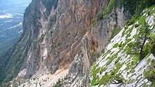
At parking lot 6 (1403 m) there is an alpine garden (separate entry) and the Rote Wand viewing platform with a view of the rocky eruptions that occurred in a landslide in 1348
The end of the street is at Rosstratte (parking lot 11, 1732 m). Several hiking trails that start here lead to the summit of the Dobratsch. You can also find here
- the mountain restaurant Rosstrattenstüberl ,
- a sculpture park, which was set up in 2009 after the end of the Krastal sculpture symposium on the edge of the parking lot and in the surrounding area,
- a hill (1740 m) with wooden loungers, panorama boards that explain the alpine surroundings, and since 2016 with a solar observation station made up of four menhirs , three sundials and a copy of the Nebra sky disc .
The Villacher Alpenstraße is open all year round and is managed by the Großglockner Hochalpenstraßen AG .
Denzel scale : 1–2
Web links
Individual evidence
- ↑ www.5min.at/ New experience on the Rosstratte
- ↑ Salzburg Wiki: Villacher Alpenstraße "New Sun Paths" opened on Villacher Alpenstraße
- ^ Working group sundials in the Austrian Astronomical Association: ... a "Klein-Stonehenge" built with the significant help of Adi Prattes.
- ↑ Denzel, Harald; Great Alpine Road Guide; 22nd edition; Denzel-Verlag Innsbruck 2005, ISBN 3-85047-764-9
Coordinates: 46 ° 36 ' N , 13 ° 43' E


