
Fellhorn (Allgäu Alps)
| Fellhorn | ||
|---|---|---|
 Fellhorn over the Gundsattel |
||
| height |
2037 m above sea level NHN 2038 u m. A. |
|
| location | Border Bavaria , Germany / Vorarlberg , Austria | |
| Mountains | Southeastern Walsertal Mountains , Allgäu Alps | |
| Dominance | 1.9 km → Warmatsgundkopf | |
| Notch height | 230 m ↓ Gundsattel | |
| Coordinates | 47 ° 21 '1 " N , 10 ° 13' 2" E | |
|
||
| Development | 1973 by the Fellhornbahn | |

The Fellhorn is a 2037 m above sea level. NHN (according to Austrian measurements: 2038 m above sea level ) high mountain in the Allgäu Alps near Oberstdorf . Its summit lies on the Austrian-German border between Kleinwalsertal and Stillachtal . It is one of the flower mountains of the Allgäu Alps and is known for its large alpine rose fields .
Development
A cable car, the Fellhornbahn , has been running from the Stillachtal up to the mountain since 1972 . The mountain station is at an altitude of 1967 m . There is a lift connection to the Kanzelwandbahn . The cross-border ski area Fellhorn / Kanzelwand has a total of 24 kilometers of slopes and 14 lifts.
photos
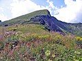
Summit from the east
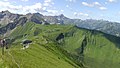
View to the southwest


Web links
Commons : Fellhorn - Collection of images, videos and audio files
Individual evidence
- ^ Federal Office for Metrology and Surveying Austria: Austrian Map online (Austrian map 1: 50,000) . Retrieved August 21, 2017.
- ↑ Fellhorn / Kanzelwand ski area , accessed on April 5, 2012