Tasman glacier
| Tasman glacier | ||
|---|---|---|
|
LandSat image of the Southern Alps with Aoraki / Mount Cook . The Tasman Glacier is to the north of the image |
||
| location | South Island (New Zealand) | |
| Mountains | New Zealand Alps | |
| length | 27 km | |
| width | Max. 3 km | |
| Coordinates | 43 ° 33 ′ S , 170 ° 16 ′ E | |
|
|
||
| drainage | → Tasman River | |
|
The tongue of the Tasman Glacier and Tasman Lake |
||
|
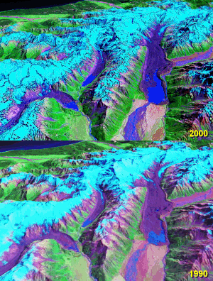
From left to right: The Müller , Hooker and the Tasman Glacier in the Southern Alps, as can be seen from the retreat in the years from around 1990 to 2000. |
||
The Tasman Glacier ( Tasman Glacier ) is the largest of a group of glaciers in the New Zealand Alps on New Zealand's South Island . These extend south and east facing the Mackenzie Basin .
The Tasman Glacier is 27 km long, up to 3 km wide and lies entirely within the area of Mount Cook National Park .
The glacier extends in a southerly direction on the southern slopes of the minarets and the eastern flank of the Aoraki / Mount Cook , the summit of which is only 5 km away from the glacier. From the northeast, the Tasman Glacier meets the meltwater of the Murchison Glacier .
The meltwater from both glaciers flows into the Tasman River , which flows southward and flows into Lake Pukaki , just like the water from the Hooker Glacier and Müller Glacier . The water north of Oamaru reaches the Pacific Ocean via the Witaki River .
The retreat of the glaciers
Noticeable are the growing tongue basin lakes , the decline of the "white ice" (ice without moraine material ) and the growth of the moraine in comparison to the ice melt. The glacier is on the retreat. In the period from 1976 to 2007 he lost around 5 kilometers.
From the merging of several small meltwater lakes, Tasman Lake was created by 1990 , which by 2008 had reached 7 km in length, 2 km in width and 245 m in depth and is still growing.
In the wake of the Christchurch earthquake in February 2011 , a piece of ice with an estimated mass of 30 million tons broke off the Tasman Glacier. It plunged into the lake at the end of the glacier, creating a three and a half meter high tidal wave.
Web links
- Satellite Image Atlas of Glaciers of the World, Glaciers of New Zealand , Chinn, TH, USGS Professional Paper 1386, 1988.
- Tasman Glacier on Glaciers-online (English)
Individual evidence
- ↑ http://earthobservatory.nasa.gov/IOTD/view.php?id=49553
- ↑ Quake shakes 30m tonnes of ice off glacier (English) , New Zealand Herald. February 22, 2011. Retrieved February 28, 2011.


